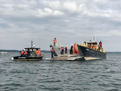
NOAA’s Office of Response and Restoration (OR&R) is tasked with responding to oil spills, chemical accidents, and other emergencies in coastal areas. OR&R’s expertise spans oceanography, biology, chemistry, and geology, allowing the response team to estimate oil and chemical trajectories, analyze chemical hazards, and assess risks to coastal animals, habitats, and important commercial and recreational areas. OR&R teams, led by regional Scientific Support Coordinators, provide scientific support to the U.S. Coast Guard for spills in coastal waters.
Disaster Preparedness Program Supports Response to Pandemic
SUPPORTS NOS PRIORITY: PREPAREDNESS AND RISK REDUCTION
The Office of Response and Restoration’s (OR&R) Disaster Preparedness Program (DPP) supported NOAA preparedness and response operations to the ongoing COVID-19 pandemic. As the incident coordinator for NOS, the DPP is responsible for coordinating across NOS program offices during an event when multiple offices are impacted. The program continues to collect information on NOS mission readiness, logistical needs, and impacts to personnel and infrastructure.
During the COVID-19 response, the program coordinated information on the tracking and safety of all NOS staff and impacts to numerous sanctuaries, reserves, facilities, and laboratories. Ensuring situational awareness and fostering collaboration were critical aspects of helping NOS leadership make informed decisions to keep its workforce safe, while continuing to execute the NOS mission.
Throughout the response, staff supported the NOAA Homeland Security Program Office by leading the After Action Reporting/Lessons Learned Unit. Program staff developed a process to capture lessons learned across the agency, and memorialize new processes for the future. Additionally, the program supported community recovery needs by working with NOAA Fisheries to coordinate CARES Act information dissemination through the Recovery Support Function Leadership Group and several state COVID-19 forums.
Sensitivity Maps Updated for Pollution Response and Planning
SUPPORTS NOS PRIORITIES: SAFE AND EFFICIENT TRANSPORTATION AND COMMERCE • PREPAREDNESS AND RISK REDUCTION • STEWARDSHIP, RECREATION, AND TOURISM
Debris on Channel Islands Beach, California.
OR&R has created Environmental Sensitivity Index (ESI) maps for the entire U.S. shoreline, its territories, and several international locations. ESIs provide critical response information, serve as a tool for various stakeholders, and protect the environment. For almost 40 years, these maps have served as the foundation of resource risk analysis for pollution emergencies, while also aiding in the identification of vulnerable resources and habitats in advance of emergencies for response planning.
In March 2020, OR&R completed updates to ESI maps and data for two Great Lakes regions — the Straits of Mackinac and the St. Clair-Detroit River System. These busy shipping routes also contain two 20-inch diameter pipelines that carry nearly 23 million gallons of oil per day. These areas are habitats rich with managed natural areas and preserves, sensitive wetlands, and numerous threatened and endangered species.
The new ESI digital data and maps are available for download, and can also be viewed in Great Lakes ERMA®. OR&R recently established a new agreement with the U.S. Coast Guard to update another set of Great Lakes ESI maps for the St. Marys and St. Lawrence rivers.
Marine Debris Program Awards Funding for Prevention, Removal, Disaster Response
SUPPORTS NOS PRIORITY: STEWARDSHIP, RECREATION, AND TOURISM
The NOAA Marine Debris Program (MDP) is proud to support projects around the U.S. and territories that assess, remove, and prevent marine debris. In 2020, MDP provided approximately $10.9 million in federal funds for impactful, community-driven, and cost-effective projects.
MDP provided approximately $2.7 million to 23 recipients of the program’s 2020 removal and prevention grant awards. Matched by non-federal contributions, the total investment of these marine debris projects is approximately $5.9 million. These projects will improve ecological resources through the removal of marine debris, as well as provide the knowledge and resources necessary to change behaviors, raise awareness, and promote the long-term prevention of marine debris.
Following the destructive 2018 hurricane and typhoon seasons, NOAA received disaster relief funding to aid in coastal recovery efforts in North Carolina, Florida, and the Commonwealth of the Northern Mariana Islands. In 2020, NOAA and the National Fish and Wildlife Foundation awarded $8.2 million in federal funds through the Hurricane Response Marine Debris Removal Fund to six projects that assess, remove, and dispose of marine debris that was caused or moved by the storms. The projects will help to prevent further harm to habitats and wildlife.
Panama City, Florida, after Hurricane Michael.
Responding to Disasters with Cutting-Edge Spatial Data Tools
SUPPORTS NOS PRIORITIES: SAFE AND EFFICIENT TRANSPORTATION AND COMMERCE • PREPAREDNESS AND RISK REDUCTION • STEWARDSHIP, RECREATION, AND TOURISM
In 2020, OR&R made significant improvements to two of its spatial data tools by enhancing decision-making capabilities, the ability to address risks, and ensure restoration and recovery efforts are under way.
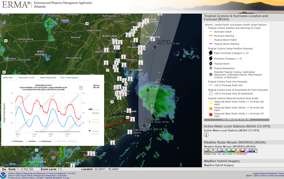
ERMA® (Environmental Response Management Application) supports mapping and data visualization needs for responders across NOAA, partner agencies, and researchers. ERMA saw a nearly 10% increase in user sessions over 2019. This increase was a result of major updates to system architecture and new data, tools, and components — with 2,222 data layers added, 1,388 of which are publicly accessible. The ERMA development team partnered with the National Weather Service (NWS) to collaborate in a new joint effort to significantly improve NWS data dissemination.
The DIVER (Data Integration, Visualization, Exploration, and Reporting) application is an electronic warehouse that stores and shares environmental data. DIVER improvements, based on user feedback, included enhanced photo management tools, new data queries for toxicity calculations, and updated help files to better explain approaches for data analysis. Developers also focused on increasing performance and query speed. Nearly 128,725 field observations and photo record updates were added to the data warehouse, and hundreds of case records were added to the document libraries, to support natural resource damage assessment cases nationwide.
Image from ERMA showing Tropical Storm Fay data off the coast of North Carolina on July 9, 2020, with predicted and actual water levels.
Communicating 30 Years of Oil Spill Science
SUPPORTS NOS PRIORITIES: PREPAREDNESS AND RISK REDUCTION • STEWARDSHIP, RECREATION, AND TOURISM
With the passing of both a decade since the Deepwater Horizon disaster, and the 30 year anniversary of the Oil Pollution Act of 1990, 2020 presented several opportunities to highlight advances in oil spill response and restoration.
The Oil Pollution Act of 1990 significantly improved measures to prevent, prepare for, and respond to oil spills. Thirty years later, OR&R highlighted the act in an online campaign titled The Oil Pollution Act of 1990: 30 Years of Spill Response and Restoration. The campaign, which led to national media coverage, explored how NOAA and its partners have supported and continue to support this important legislation.
 An official website of the United States government.

Social