NOAA’s Office for Coastal Management (OCM) works to keep the nation's coasts safe from storms, rich in natural resources, and economically strong. The office administers the National Coastal Zone Management Program, the Coral Reef Conservation Program, the Digital Coast, and the National Estuarine Research Reserve System.
New Statistics Show Marine Economy Worth $373 Billion in GDP
SUPPORTS NOS PRIORITY: STEWARDSHIP, RECREATION, AND TOURISM
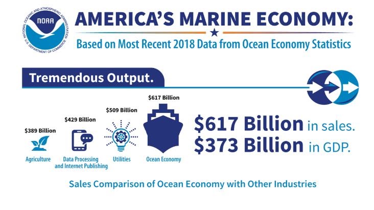
NOAA’s release of new national marine economy statistics provides impressive data about the marine economy: $373 billion in gross domestic product, a workforce of 2.3 million, and $617 billion in sales in 2018. The report offers first-of-its-kind national estimates for all ocean, coastal, and Great Lakes economic activity by major industry. The information is used to help people understand the value of the marine economy and make smart business investment, conservation-based, and resource-dependent decisions. This was a joint venture between NOAA's Office for Coastal Management, NOAA’s Office of the Chief Economist, and the Department of Commerce Bureau of Economic Analysis.
NOAA’s new national marine economy statistics provide impressive data highlighting first-of-their-kind national estimates for all ocean, coastal, and Great Lakes economic activity.
NOAA Announces First Recipients of New Graduate Fellowship
SUPPORTS NOS PRIORITIES: PREPAREDNESS AND RISK REDUCTION • STEWARDSHIP, RECREATION, AND TOURISM
OCM welcomed the first class of the Margaret A. Davidson Graduate Fellowship program, which is building the next generation of coastal science and resource management professionals. The fellowship, which is open to students enrolled in a master’s or Ph.D. program, gives participants the opportunity to conduct research within one of the 29 national estuarine research reserves. The inaugural class includes one fellow for each reserve. Each project is focused on collaborative research that will help scientists and communities better address coastal challenges and increase resilience. The fellowship honors the legacy of Margaret A. Davidson, a true visionary and pioneer in the coastal science resource management world.
NOAA’s new competitive fellowship is building the next generation of coastal science and resource management professionals while honoring the legacy of Margaret A. Davidson, a true visionary and pioneer in the field.
SUPPORTS NOS PRIORITY: PREPAREDNESS AND RISK REDUCTION
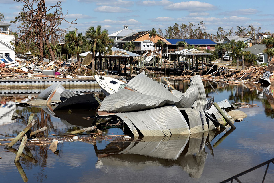
Two competitive funding programs are helping coastal communities prepare for, withstand, and recover from storms and other natural hazards. The $31 million provided through the competitive National Coastal Resilience Fund restored and strengthened the natural systems that protect coastal communities from storms and flooding while enhancing habitat for species and spurring economic development. The $48.5 million invested through the Emergency Coastal Resilience Fund benefited counties that received presidential disaster declarations due to Hurricanes Florence and Michael, Typhoon Yutu, and coastal California wildfires. OCM works in partnership with the National Fish and Wildlife Foundation to administer this program, leveraging additional funding from Shell Oil, TransRe, and the Environmental Protection Agency.
NOAA’s coastal resilience funding helps coastal communities prepare for, withstand, and recover from storms such as Hurricane Michael, which left this devastation in Mexico Beach, Florida. Photo courtesy of U.S. Coast Guard/Petty Officer 3rd Class Hunter Medley.
NOAA’s Historical Hurricane Tracking Tool Gets Major Facelift
SUPPORTS NOS PRIORITY: PREPAREDNESS AND RISK REDUCTION
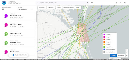
While hurricane forecasts are important, people are also interested in historical hurricane trends. Understanding past occurrences can aid in planning and preparing for future hurricanes. This year, NOAA’s popular Historical Hurricane Tracks website received major updates in both look and functionality. The updated site accesses and displays hurricane tracks from multiple NOAA data sets in one user-friendly location. The search function makes it easy for users to find and explore tropical storms by name, year, or area, the results of which can be saved and shared easily with others. The effort was led by OCM. Over 198,000 people used this site during Fiscal Year 2020, and during hurricane season the site typically sees an average increase in user visitation of approximately 56%.
The recently updated Historical Hurricane Tracks site accesses and displays hurricane tracks from multiple NOAA data sets in one user-friendly location, allowing users to find and explore tropical storms by name, year, or area.
SUPPORTS NOS PRIORITY: PREPAREDNESS AND RISK REDUCTION
Accurate, high-resolution elevation data are critical for effective planning and coastal management — but these data can be expensive. OCM is working with federal, state, and local partners to cost-share data acquisition efforts. This information is then provided at no cost on NOAA’s Digital Coast website for all to use. This effort results in lower costs to taxpayers, higher quality data, and newer technology for all end users. Some examples where the data have been used include: the Hawaiian Islands leveraging data from the United States Geological Survey’s 3D Elevation Program; high-resolution mapping projects using data for impervious features such as buildings, roads, pavement, parking lots, and driveways; and salt marsh habitat maps.
NOAA’s high-resolution land cover data, as seen here for Connecticut, shows a significant amount of impervious surface (white) and wetlands (purple). These data are available free of charge thanks to cost-sharing efforts with federal, state, and local partners.
NOAA’s Natural Infrastructure Trainings, Tools Lead to Results
SUPPORTS NOS PRIORITY: PREPAREDNESS AND RISK REDUCTION
Natural infrastructure projects are rising in popularity. This “green” approach is good for the environment, often improves aesthetic and recreational values, provides natural habitat, and can decrease flooding and erosion. OCM continues to develop new resources and products that help coastal communities select the right approach for their unique situations. These products include training programs, tools, and quick references, which thousands benefited from during Fiscal Year 2020 .
In FY 2020, staff delivered the new Nature-Based Solutions for Coastal Hazards training to 329 participants. Staff quickly adapted this training to a virtual platform, resulting in half of the total participants taking the training virtually. New on-demand resources provided information on natural infrastructure right when users needed it. Examples include a suite of new quick references focused on the costs and benefits of natural infrastructure approaches, and literature related to the economics of natural infrastructure. There were over 4,000 online peer-to-peer case study visits focused on natural infrastructure and resilience. Two of these studies shared lessons learned from incorporating solutions into mitigation strategies post-Hurricane Maria, and focused on transportation infrastructure resilience in California.
In total, over 1,500 coastal professionals across the country were trained in OCM’s instructor-led courses this year. Each course works to build the skills communities need to address climate impacts.
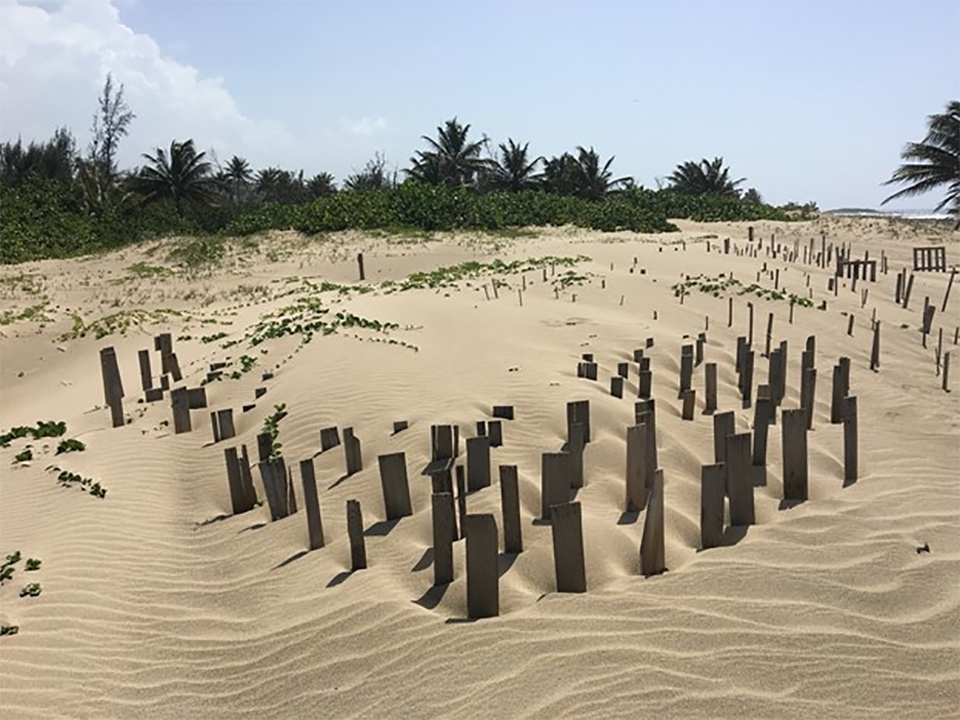
NOAA’s natural infrastructure training programs, tools, and quick references have benefited thousands, leading to tangible results — such as this successful biomimicry natural infrastructure project in Puerto Rico.
 An official website of the United States government.


Social