Hurricane Sally began as a tropical wave off the eastern Bahamas on September 9, 2020. On September 10, additional tropical weather outlooks indicated the potential for development had increased. On September 11, the wave became a tropical depression. Sally would remain disorganized and moderately sheared for much of its trip across the Florida Peninsula into the Gulf of Mexico. As steering currents collapsed, Sally slowed significantly, which set the stage for a historic flooding event across the Florida Panhandle and into Alabama. Sally made landfall on September 16 near Gulf Shores, Alabama. Sally's continued slow motion after landfall allowed even more rainfall to fall across Alabama and the Florida Panhandle, leading to record high river levels. Sally eventually intensified into a Category 2 storm.
Office of Coast Survey (OCS)
OCS’s Navigation Response Team (NRT) -Stennis surveyed in Pensacola Bay Channel, Florida, following Hurricane Sally at the request of the U.S. Army Corps of Engineers (USACE). This is what Nate Lovelace, Operations Division, USACE, Mobile District, had to say about OCS’s efforts:
“Having your 1st class survey team scanning the channel put our minds to rest and allowed the USCG [U.S. Coast Guard] to re-open the channel in record time this year. I hope we can continue to work together and keep setting the bar higher each time.”
With mitigation plans put in place to ensure the safety of OCS employees, NRTs and navigation managers were able to respond to Hurricane Sally, providing survey data to the USGC, enabling them to open waterways and ensure safe navigation for commercial and recreational marine traffic.
Concurrent multibeam and side scan sonar data reflect the state of the seafloor of Pensacola Bay Channel, Florida, on September 19, 2020. This image was part of a preliminary survey deliverable to the U.S. Coast Guard for decision-making purposes.
Office of Response and Restoration (OR&R)
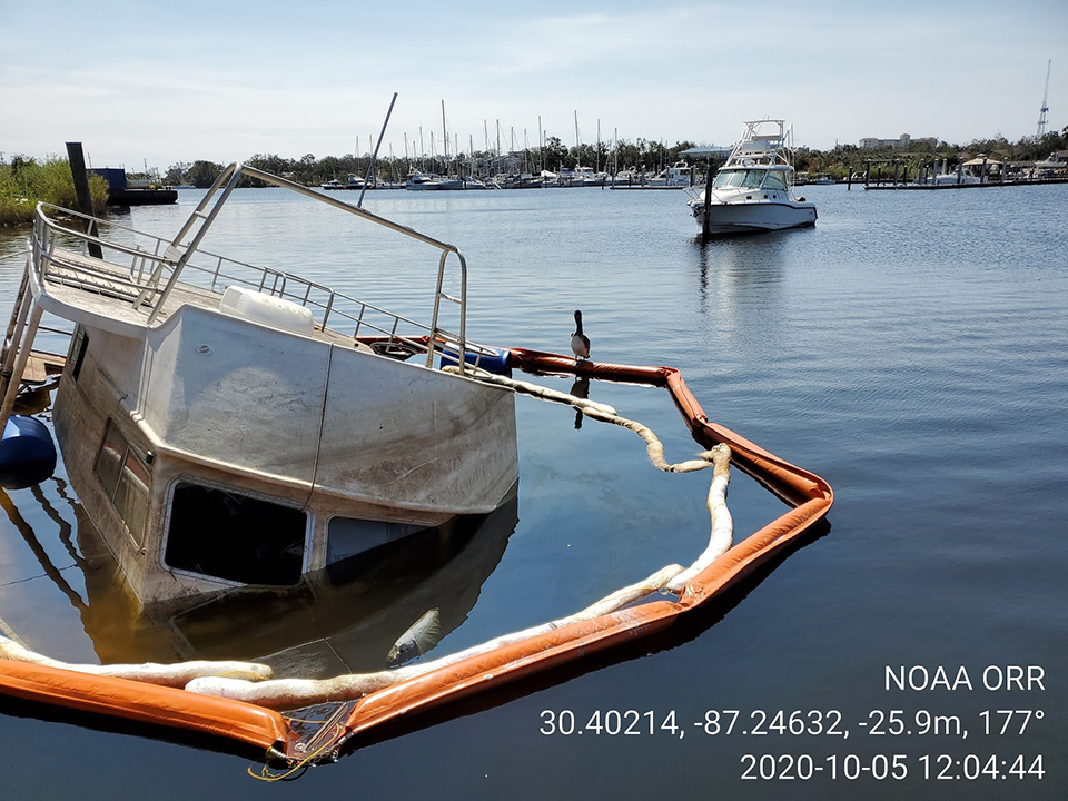
In the wake of Hurricane Sally, OR&R worked with other agencies and the U.S. Coast Guard (USGC) to identify close to 1,000 pollution targets, the majority of which were sunken and stranded commercial and recreational vessels. The storm's impacts also included a half-mile stretch of oiling along the Gulf Islands National Seashore on Perdido Key, Florida.
OR&R’s spatial data experts used the Environmental Response Management Application (ERMA) as a common operating picture to analyze aerial imagery from NOAA’s National Geodetic Survey to locate displaced vessels and potential hazardous substance releases. Identification of these targets allowed NOAA teams, working with state and federal resource agencies and the USGC, to survey the affected shore and to help track and assess vessel targets. The NOAA team is also helping to develop best management practices for vessel removal and salvage to minimize collateral impacts to historic and cultural resources and protected species.
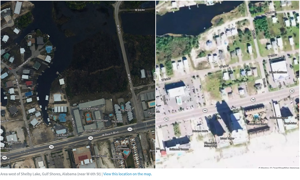
NGS collected aerial damage assessment images of areas affected by Hurricane Sally. NGS crews flew over areas identified by NOAA in coordination with the Federal Emergency Management Agency, the U.S. Coast Guard, and other state and federal partners to collect the damage assessment images. Aerial imagery is a crucial tool used to determine the extent of the damage inflicted by flooding and to assess damage to major ports and waterways, coastlines, critical infrastructure, and coastal communities. This imagery provides a cost-effective way to better understand the damage sustained to both property and the environment.
The NGS flight crew flew over more than 3,540 square kilometers during 14.1 hours and collected 5,304 images. NOAA’s aerial imagery aids safe navigation and records storm damage to coastal areas.
Before (right) and after (left) NGS aerial photographs of Shelby Lake in Gulf Shores, Alabama, taken after Hurricane Sally.
Center for Operational Oceanographic Products and Services (CO-OPS)
CO-OPS issued 142 Storm QuickLook postings for 14 tropical cyclones during Fiscal Year 2020. Storm QuickLook provides a synopsis of near real-time oceanographic and meteorological observations at locations affected by a storm and are updated three times a day. For the third year, CO-OPS communicated real-time water level information from Storm QuickLook through NOS social media during storm events.
Pensacola, Florida, measured water levels of 5.6 feet above Mean Higher High Water during Hurricane Sally, which marks the third highest water level dating back to 1923, and exceeded water levels measured during Hurricane Katrina in 2005.
Many other water level stations, which were installed over the past decade, detected new records during this extremely active Atlantic hurricane season. The CO-OPS field team in the Gulf of Mexico experienced significant impacts, interweaving hurricane preparedness and response with the limitations to travel and maintenance activities related to the pandemic. Hurricane Sally caused moderate damage to the CO-OPS Gulf Breeze, Florida, facility, with three docks lost and major damage to its boathouse. Several team members sustained damage to their personal property and homes.
 An official website of the United States government.

Social