NOAA’s National Centers for Coastal Ocean Science (NCCOS) delivers ecosystem science solutions for stewardship of the nation’s ocean and coastal resources, in direct support of NOS priorities, offices, and customers, and to sustain thriving coastal communities and economies.
Mapping Projects Support Wind Energy, Aerial Drones, Sanctuary Exploration
SUPPORTS NOS PRIORITIES: SAFE AND EFFICIENT TRANSPORTATION AND COMMERCE • PREPAREDNESS AND RISK REDUCTION
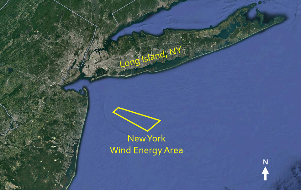
NCCOS published the results of a seafloor characterization study conducted for the Bureau of Ocean Energy Management in support of a $3 billion wind energy project in New York’s offshore waters. The project is expected to build 60 – 80 wind turbines, create 800 local jobs, and power over 500,000 homes. The study provides baseline data to help managers better evaluate the potential impacts of offshore wind energy development, and identify additional potential wind energy sites in the region. The findings show that the area is conducive to building wind farm infrastructure.
NCCOS and partners published guidelines for using aerial drones to map the nearshore coastal seafloor. Aerial drones, outfitted with cameras and supported with photogrammetry software, may offer an inexpensive and accurate way to map nearshore waters that are difficult to access, generating the imagery and water depth data needed by coastal managers. The new report provides the results and analyses from over 100 drone mapping flights along the coasts of California and the U.S. Virgin Islands, and evaluates the influence of airframes, sensors, environmental conditions, and processing procedures.
Using the latest sonar technology, along with divers, NCCOS and partners surveyed part of the lakebed in Michigan’s Thunder Bay National Marine Sanctuary to support better management of underwater resources there. The researchers are using data from these missions to develop high resolution maps of shipwrecks, invasive mussel distributions, and important fish habitats in the sanctuary. Less than 20% of the sanctuary has been mapped using modern sonar technology.
Map of New York Wind Energy Area from September 2020. 79,350 acres located south of Long Island, New York, approximately 13 miles off Rockaway Peninsula.
New Harmful Algal Bloom Tools Help Inform and Protect the Public
SUPPORTS NOS PRIORITIES: PREPAREDNESS AND RISK REDUCTION
The experimental Florida red tide respiratory forecast — launched by NCCOS and partners in 2018 for Pinellas County, Florida, now includes Sanibel Island. The forecast informs visitors of the daily severity of airborne red tide toxins at area beaches, which is particularly important for individuals that have repository conditions. The respiratory forecast is part of a NOAA ecological forecasting initiative that aims to deliver accurate, relevant, timely, and reliable ecological forecasts directly to coastal resource managers and the public.
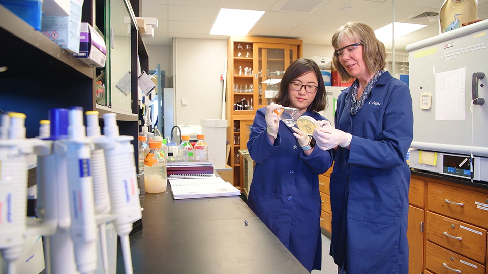
NCCOS-funded scientists characterized a naturally occurring and environmentally safe algicidal compound produced by the bacterium Shewanella, and confirmed that the compound can selectively kill marine dinoflagellates; these dinoflagellates produce harmful algal blooms (HABs). The team is now testing a delivery method of embedding the bacteria in gel-like beads contained in mesh bags. The bags can be temporarily deployed in coastal waters to prevent HABs from occurring, or to shut down or mitigate existing blooms.
Another NOAA-funded study may help resume shellfish trade between the U.S. and the European Union (EU) by answering questions about the prevalence and toxicity of HAB-derived lipophilic (fat-soluble) toxins in shellfish. In 2010, the EU halted imports of U.S. molluscan shellfish following reciprocal reviews of the equivalency of EU and U.S. shellfish sanitation programs. Aided by data from the new study, the U.S. Food and Drug Administration completion of equivalence determinations will allow restoration of the shellfish trade between select U.S. states and EU member countries.
With funding from NCCOS, University of Delaware Professor Kathryn Coyne (right) and doctoral student Yanfei Wang conduct an experiment using the Shewanella bacteria-derived compound that can selectively kill marine dinoflagellates that produce harmful algal blooms. University of Delaware, September 2019. Credit: University of Delaware.
New Oyster Restoration Strategy Theory Benefits Growers, Regulators
SUPPORTS NOS PRIORITIES: SAFE AND EFFICIENT TRANSPORTATION AND COMMERCE • PREPAREDNESS AND RISK REDUCTION
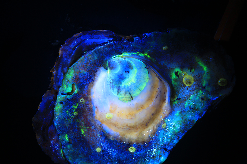
Traditional oyster restoration strategies involve seeding oyster shells with lab-harvested oyster larvae in aquariums before placing the seeded shells in their natural habitat. But what if larvae could be directly released into open water oyster reefs? A new NCCOS study in the Chesapeake Bay shows that this approach can work. Based on the team’s positive oyster larvae settlement results, researchers are now investigating the scalability and applicability of the new deployment method for large scale oyster restoration and aquaculture operations.
The technique developed to test the theory also has benefits. The team identified deployed oyster larvae by “tagging” their shells with a fluorescent dye prior to release. The non-toxic dye, approved by the U.S. Food and Drug Administration and U.S. Fish and Wildlife Service, glows under special light, and can last many months as oyster larvae settle and grow. Tagging shells will allow oyster farmers, health officials, and enforcement agencies grappling with oyster poachers the ability to identify the origin of oysters.
The calcein fluorescent dye “tag,” shown here glowing under special light, confirms that this oyster retrieved from an open water oyster reef was one of the oyster larvae the researchers released directly onto the reef. Credit: Cooperative Oxford Laboratory in Oxford, Maryland, September 2019.
New Report Summarizes Magnitude, Effects of Contaminants in U.S. Coastal Waters
SUPPORTS NOS PRIORITIES: PREPAREDNESS AND RISK REDUCTION
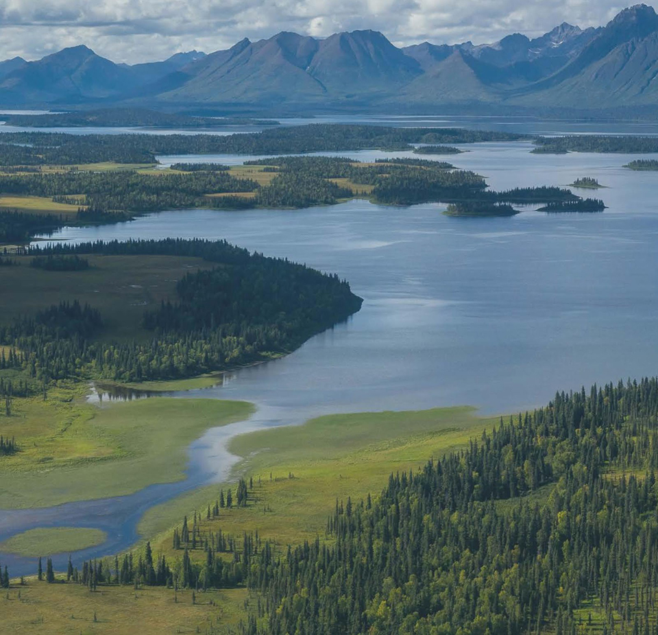
An NCCOS report summarizes the NCCOS Bioeffects Program’s assessments of U.S. estuaries and bays going back to the early 1990s. Now, each of these studies are in a standard format, allowing comparisons across locations and regions. The assessments include analyses of a comprehensive list of organic and inorganic chemical contaminants in sediment and tissue, multiple toxicity bioassays, and benthic biological community evaluations. The researchers completed studies on the Atlantic (including the U.S. Caribbean), Gulf of Mexico, Pacific, and Alaskan coasts. All of these data are available for download at NOAA’s National Status and Trends data portal.
Bioeffects studies not only look at the distribution and concentration of contaminants in an area of concern, but also whether the amounts present are toxic, and what impact those contaminants might have on the diversity and abundance of animals living there. Data are used in environmental risk assessments, damage assessments, and natural resource management and restoration activities. Bioeffects assessments also provide baseline habitat condition evaluations that are used to quantify the impact of oil and chemical spills, natural disasters, and industrial development projects.
Researchers conducted environmental assessments of economically important estuaries across the nation, such as Bristol Bay, Alaska (shown here in July 2014), which hosts the largest sockeye salmon fishery in the world.
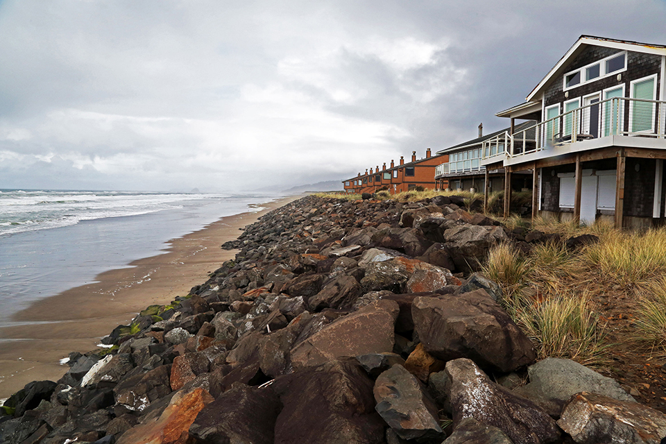
Shoreline Armoring Devalues Adjacent, At-risk, Unarmored Land
SUPPORTS NOS PRIORITIES: PREPAREDNESS AND RISK REDUCTION • STEWARDSHIP, RECREATION, AND TOURISM
NCCOS-funded research in Oregon shows that armoring coastal properties threatened by shoreline erosion economically benefits the owners of such properties at the expense of adjacent, at-risk, unarmored properties. Common shoreline armoring structures include rock revetments (also called “rip-rap”), seawalls, and breakwaters, which protect coastal property by holding back the sea and preventing the loss of sediment.
The study found that armoring properties eligible for such protection can increase their value, but adjacent properties ineligible for armoring sell for less. Adjacent, unarmored properties not vulnerable to erosion are not affected either way. To protect beaches from over-development, Oregon prohibits “armoring” private property developed after 1976. An impact of this policy is that armored properties can change sediment flows and redirect waves to erode shoreline at adjacent, at-risk, unarmored properties.
Some oceanfront landowners in Oregon have chosen to use rock revetments, or rip-rap, to protect their properties from shoreline erosion. Their decision has implications for property values, public access, and recreation. Neskowin, Oregon, January 2020. (Credit: Oregon State University.)
 An official website of the United States government.
Social