Hurricane Laura rapidly strengthened on August 26 in the Gulf of Mexico. By the time Laura reached southwest Louisiana early on August 27, maximum sustained winds reached 150 mph. This part of the state had never experienced such a powerful (Category 4) hurricane. As Hurricane Laura approached the Louisiana Coast, a persistent cluster of thunderstorms dumped three to more than six inches of rain over a small part of western Arkansas during the morning of August 26. Measured gusts exceeded 130 mph in Lake Charles, Louisiana. Widespread damage was sustained.
In the next 24 hours there was a swath of heavy rain throughout the state, resulting in flooding. As the remnants of Laura tracked into the state, winds kicked up and lasted for several hours. Excessive wind resulted in many downed trees and power lines, with some trees on houses. Minor structural damage was reported. There were at least 50,000 power outages.
Eight tornadoes were counted as a result of Hurricane Laura — the largest August outbreak of tornadoes in recorded history across the state. August low pressure records were set in multiple cities.
Office of Coast Survey (OCS)
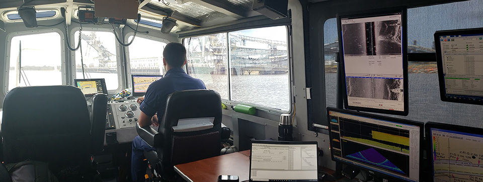
OCS’s navigation response teams (NRTs) completed hydrographic surveys in areas affected by Hurricane Laura at the request of the U.S. Coast Guard (USCG) and U.S. Army Corps of Engineers. The team found submerged features in Galveston Bay, Texas, and Calcasieu Ship Channel, Louisiana, and reported the information to the USCG. The teams collected high-definition photographs of three assets belonging to NOAA's Center for Operational Oceanographic Products and Services at the entrance of the Calcasieu Ship Channel. OCS quickly initiated negotiations and put in place project instructions for a hydrographic survey contractor to conduct response surveys in the area.
With mitigation plans put in place to ensure the safety of OCS employees, NRTs and navigation managers were able to respond to Hurricane Laura, providing survey data to the USGC, enabling them to open waterways and ensure safe navigation for commercial and recreational marine traffic.
Lt. John Kidd, officer in charge of Navigation Response Team-Stennis, operates the vessel in Devil’s Elbow, Missouri, while collecting detailed bathymetric data for the Captain of the Port.
Office of Response and Restoration (OR&R)
OR&R supported the U.S. Coast Guard response to Hurricane Laura by providing trajectory analysis to show where any spilled oil or chemicals may have gone, and helped to identify specific debris targets from NOAA's National Geodetic Survey imagery, which was generated post-landfall.
Days before the storm hit, OR&R coordinated with NOAA's National Environmental Satellite, Data, and Information Service to facilitate access to post-storm imagery, which helps experts search for damage to or pollution from offshore wells and platforms. OR&R also coordinated with other federal partners in the Environmental Protection Agency and the U.S. Department of the Interior to ensure readiness. The Environmental Response Management Application saw a 410% increase in visits leading up to and shortly after Hurricane Laura’s landfall.
Hurricane Laura created an estimated ten million cubic yards of debris, of which, as of this writing, approximately 60% has been removed with a variety of federal and state funding sources. OR&R’s Marine Debris Program evaluated the extent and impacts of debris in waterways, marsh habitats, and coastal areas — providing best management practices for debris removal from sensitive environments.
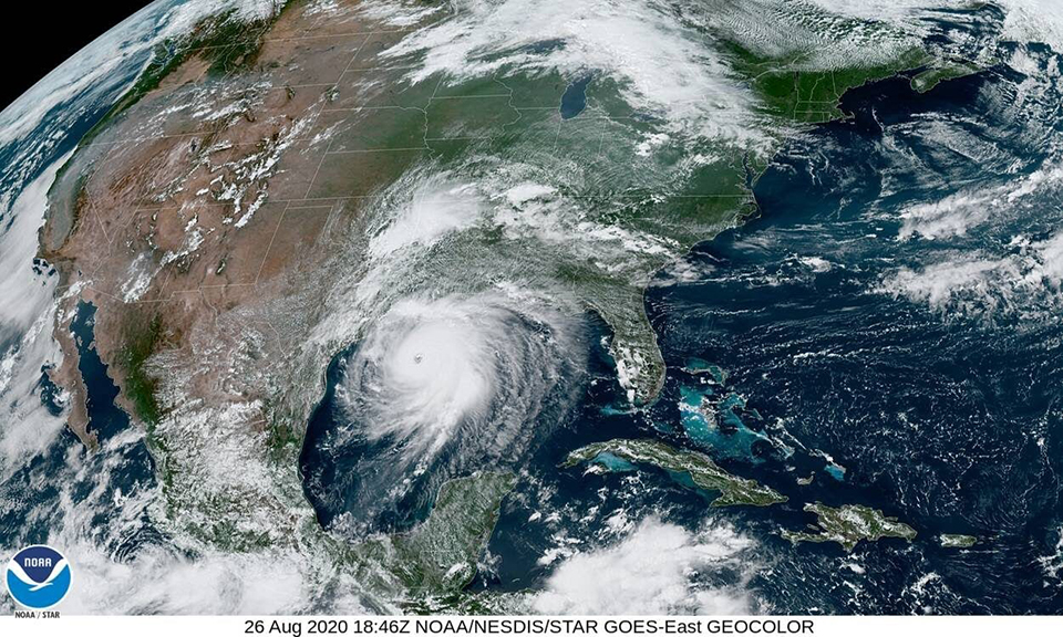
Imagery of Hurricane Laura from NOAA’s GOES-East satellite.
National Geodetic Survey (NGS)
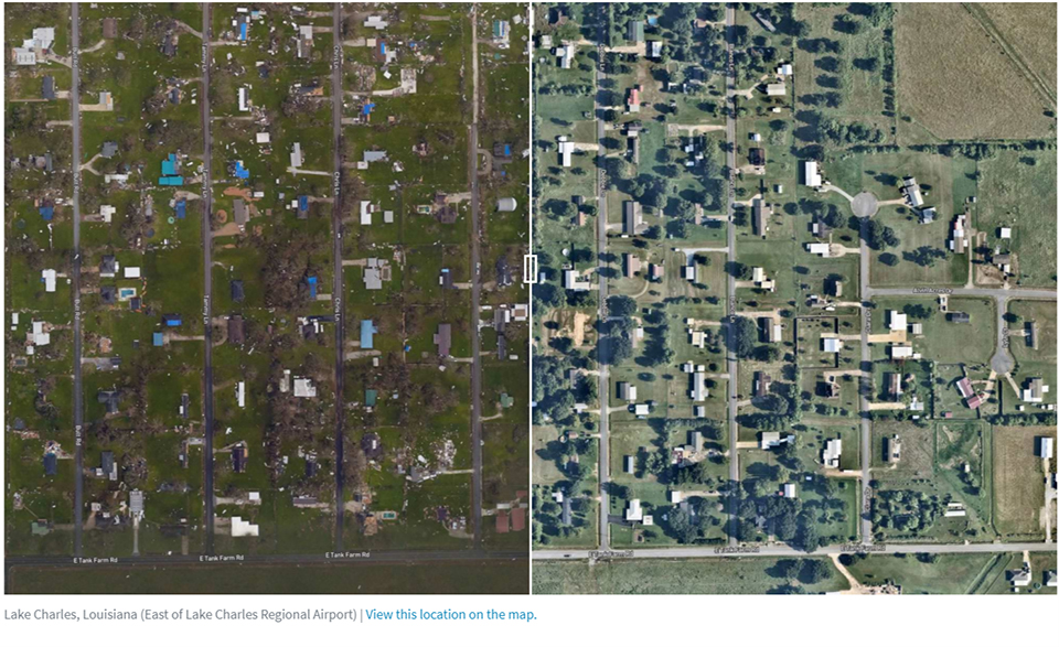
NGS collected aerial damage assessment images of areas affected by Hurricane Laura. NGS crews flew over areas identified by NOAA in coordination with the Federal Emergency Management Agency, the U.S. Coast Guard, and other state and federal partners to collect the damage assessment images. Aerial imagery is a crucial tool used to determine the extent of the damage inflicted by flooding and to assess damage to major ports and waterways, coastlines, critical infrastructure, and coastal communities. This imagery provides a cost-effective way to better understand the damage sustained to both property and the environment.
The NGS flight crew flew over 7,000 square kilometers during the course of 29.3 hours and collected 23,401 images. NOAA’s aerial imagery aids safe navigation and records storm damage to coastal areas.
Before (right) and after (left) NGS aerial photographs taken as a result of Hurricane Laura in Lake Charles, Louisiana.
Center for Operational Oceanographic Products and Services (CO-OPS)
CO-OPS issued 142 Storm QuickLook postings for 14 tropical cyclones during Fiscal Year 2020. Storm QuickLook provides a synopsis of near real-time oceanographic and meteorological observations at locations affected by a storm and are updated three times a day. For the third year, CO-OPS communicated real-time water level information from Storm QuickLook through NOS social media during storm events.
CO-OPS provided tidal information to the Office of Coast Survey (OCS) to support its post-storm emergency hydrographic surveys, and provided emergency tide support to OCS for a bathymetric survey associated with Hurricane Laura. During the storm, water level stations at Calcasieu Pass, Louisiana, detected water levels at 9.19 feet above Mean Higher High Water, just behind the all-time record of 10.01 feet, which was observed during Hurricane Ike.
Many other water level stations, which were installed over the past decade, detected new records during this extremely active Atlantic hurricane season. The CO-OPS field team in the Gulf of Mexico experienced significant impacts, interweaving hurricane preparedness and response with the pandemic limitations to travel and maintenance activities.
 An official website of the United States government.
Social