The Office of Coast Survey (OCS) provides navigation products and services that ensure safe and efficient maritime commerce on America’s ocean and coastal waters, and in the Great Lakes.
OCS Takes Major Steps to Modernize Charting Products
SUPPORTS NOS PRIORITY: SAFE AND EFFICIENT TRANSPORTATION AND COMMERCE
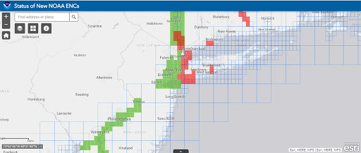
New Jersey and surrounding area displayed in the new web map service. The green cells represent completed harbor scale band 5 electronic navigational charts.
OCS is in the midst of a multi-year program to improve its NOAA electronic navigational charts (NOAA ENC®) coverage by replacing over 1,200 irregularly shaped ENC cells, compiled in over 130 different scales, with a standard gridded layout of ENCs, compiled in just a dozen standard scales. OCS released a map viewer featuring the status of these improved charts as they undergo major improvements. Seeing the increased reliance on ENCs as the primary navigational product for mariners and the decreased use of traditional raster and associated paper chart products, OCS initiated a five-year plan to end raster chart production. OCS coordinated details of this “sunsetting” effort with its primary charting partners, the U.S. Coast Guard, the U.S. Army Corps of Engineers, and the National Geospatial-Intelligence Agency, as well as third-party chart producers. Additionally, OCS improved the organization of published navigational content and regulations for the Pacific Coast and Hawaiian Islands by splitting it into two volumes. The new U.S. Coast Pilot® 10 is the first new volume in more than 60 years.
OCS Releases Ocean Mapping Strategy to Support Federal Initiative
SUPPORTS NOS PRIORITY: SAFE AND EFFICIENT TRANSPORTATION AND COMMERCE
DriX — an uncrewed surface vessel — is under way from NOAA Ship Thomas Jefferson with the deployment system still in the water. OCS will leverage leading-edge survey technology (such as the DriX) to force multiply data acquisitions as outlined in its ocean mapping strategy.
OCS Completes Upgrade of Global Surge and Tide Forecast System
SUPPORTS NOS PRIORITY: PREPAREDNESS AND RISK REDUCTION
The Extratropical Surge and Tide Operational Forecast System (ESTOFS) is one of the oldest-running coastal storm surge operational forecast systems developed by OCS in collaboration with other National Ocean Service, National Weather Service, and academic partners. Since 2012, the ADvanced ocean CIRCulation model (ADCIRC)-based ESTOFS has been deployed for the U.S. East and Gulf Coasts and the Caribbean (ESTOFS-Atlantic), for the U.S. West Coast and Hawaii (ESTOFS-Pacific), and for the U.S. Territories in Micronesia from Palau to Marshall Islands (ESTOFS-Micronesia).
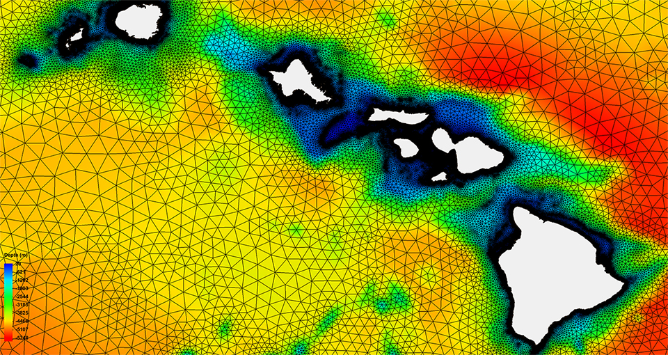
In late 2020, after years of hard work and development, Global ESTOFS became operational, superseding all three existing operational domains with superior spatial resolution and physics. State-of-the-art Global ESTOFS incorporates seamless real-time skill assessment and bias correction of its water level forecasts. Following the Unified Forecast System approach, the underlying numerical modeling core, ADCIRC, is being coupled with other applications, e.g. WAVEWATCH III, the National Water Model, and the Global Real-Time Ocean Forecast System as possible future upgrades. Global ESTOFS will serve as a backbone for future development to improve NOAA capabilities in coastal inundation prediction and open the doors for new applications, including precision marine navigation, climate studies, risk assessment, on-demand probabilistic forecasting, and more.
Global ESTOFS mesh and bathymetry for the waters surrounding the Hawaiian Islands.
NOAA Releases Prototype Surface Current Forecast Data for Industry Testing
SUPPORTS NOS PRIORITY: SAFE AND EFFICIENT TRANSPORTATION AND COMMERCE
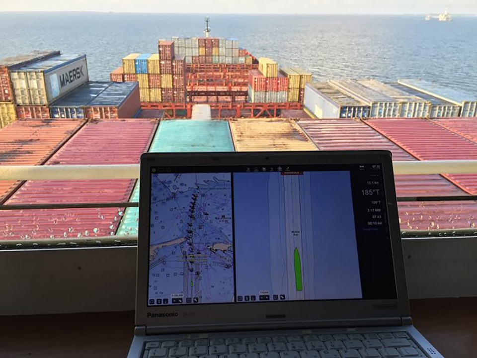
Prototype data for surface current forecasts in the International Hydrographic Organization (IHO) S-111 format was made available for testing through the NOAA Big Data Program. Industry can integrate these prototype data into different types of navigation software systems such as portable pilot units and under keel clearance systems. By making these data more accessible, more machine-to-machine readable, and more integrated, NOAA aims to amplify the power of its navigation data for users across the maritime industry.
NOAA’s Precision Marine Navigation program developed a prototype data processing and dissemination system in the public cloud to ingest, process, and disseminate NOAA hydrographic, bathymetric, oceanographic, and weather data via IHO S-100 framework compliant datasets. The S-111 surface current forecast guidance is the first data service that NOAA has released in the new S-100 standard. The data is automatically processed and uploaded to the NOAA Big Data Program every six hours. While this data is still in prototype form, it is not intended for navigation use.
The newly released S-111 standards will allow manufacturers of portable pilot units and other types of navigation software to integrate surface current forecasts into their systems.
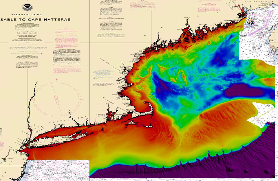
OCS Completes National Bathymetry Foundational Dataset for New England
SUPPORTS NOS PRIORITY: SAFE AND EFFICIENT TRANSPORTATION AND COMMERCE
To create a foundational dataset for next-generation nautical charts and multiple scientific disciplines, OCS’s National Bathymetric Source team compiles the national bathymetry from the best available data based on ground resolution, accuracy, and survey date. This year, the team built the New England dataset as 780 chart tiles for 63,000 square nautical miles. The New England region is now being maintained as new source surveys become available and are included in the compilation. The primary sources of bathymetry include NOAA and U.S. Army Corps of Engineers hydrographic surveys, topography-bathymetry lidar surveys, as well as other external sources. Survey quality metrics and attribution were tracked for all 1,996 New England surveys ingested, indicating the best available bathymetry. The establishment of a data-driven workflow through automation and expertise allows for increased quality, accessibility, and timeliness of bathymetric source data.
 An official website of the United States government.

Social