Center for Operational Oceanographic Products and Services
NOS Fiscal Year 2020 Year in Review
NOAA’s Center for Operational Oceanographic Products and Services (CO-OPS) is the authoritative source for accurate, reliable, and timely tides, water levels, currents, and other vital coastal oceanographic and meteorological information.
CO-OPS Expands PORTSⓇ, Enhances Safety of Marine Navigation Across U.S.
SUPPORTS NOS PRIORITY: SAFE AND EFFICIENT TRANSPORTATION AND COMMERCE
In Fiscal Year 2020, The Center for Operational Oceanographic Products and Services (CO-OPS) worked with partners to expand several of the Physical Oceanographic Real-Time Systems (PORTSⓇ) across the U.S., adding new sensors to existing PORTS and partnering with the U.S. Navy to add two new systems. PORTS is a NOAA partnership program that provides oceanographic and meteorological observations to help mariners safely navigate increasingly congested shipping lanes and seaports.
In FY 20, new sensors were added to PORTS in Tampa Bay, Florida; New York and New Jersey; Corpus Christi, Texas; and Cape Cod, Massachusetts. CO-OPS also announced the creation of two new PORTS in partnership with the U.S Navy near Kings Bay, Georgia, and Portsmouth, New Hampshire. Additionally, a new tide station on Seavey Island in Maine along the Piscataqua River will help protect shipyard personnel, critical facilities, and U.S. Navy submarines. CO-OPS now has 36 PORTS across the nation and plans to work with partners to continue expanding this important program in FY 21.
A cargo ship passes under the Sunshine Skyway Bridge in Tampa, Florida. A new air gap sensor added to Tampa Bay PORTS will help ships pass safely below the bridge.
CO-OPS Aids in Construction of Highway to Combat Sea Level Rise
SUPPORTS NOS PRIORITY: PREPAREDNESS AND RISK REDUCTION
CO-OPS provided critical science used by the Louisiana Department of Transportation and Development (LA DOTD) to acquire funding to construct an 8.3-mile elevated LA Highway 1 between Leeville and Golden Meadow in Lafourche Parish. This road is the only access to Port Fourchon and the Louisiana Offshore Oil Port. Port Fourchon currently services over 90% of the Gulf of Mexico’s deepwater oil production and plays a strategic role in furnishing approximately 18% of the United State’s entire oil supply.
LA DOTD was awarded a $135 million federal grant as a part of the U.S. Department of Transportation’s Infrastructure for Rebuilding America program for this work. This stretch of highway is increasingly closed due to flooding. CO-OPS provided flooding projections which predicted that the current highway, without modification, would be underwater for 22 days out of the year by 2030 and 201 days by 2047. This road also serves as the sole evacuation route for the Port and communities in Grand Isle and lower Lafourche Parish, and provides access to coastal marshes and wetlands undergoing vital restoration and protection efforts. This project demonstrates the important role that flood projections play in helping communities mitigate their sea level rise risks both now and in the future.
Annual High Tide Flooding Outlook Released
SUPPORTS NOS PRIORITY: PREPAREDNESS AND RISK REDUCTION
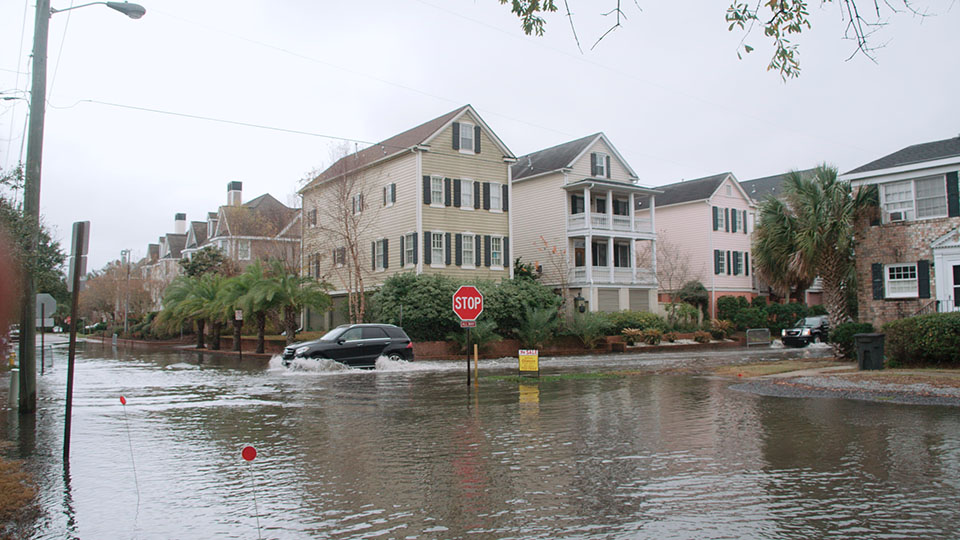
CO-OPS released its annual 2019 State of High Tide Flooding and 2020 Outlook. The report shows that coastal communities across the U.S. continued to see increased high-tide flooding in 2019, forcing residents and visitors to deal with flooded shorelines, streets, and basements — a trend that is expected to continue into the 2020 meteorological year (May 2020 to April 2021).
Each year, NOAA documents changes in high-tide flooding patterns from the previous year at 98 NOAA tide gauges along the U.S. coast, and provides a flooding outlook for these locations for the coming year, as well as projections for the next several decades. In 2019, the national annual high tide flood frequency reached four days (median value), just shy of the record of five days set in 2018. High tide flooding is now accelerating at 75% of locations along the East and Gulf Coasts. In 2019, sea levels at 90% of the tide stations monitored along the Atlantic and Gulf Coasts reached record levels. More than 19 locations broke or tied their flood records.
By 2030, high tide flooding is likely to be in the range of 7-15 days and by 2050, between 25-75 days. These long-term outlooks are based on the range of relative sea level rise ‘more likely’ to occur by 2030 and 2050 using projections from the Fourth National Climate Assessment. The data from this report gives coastal communities the information they need to make informed decisions about how to handle disruptive flooding for the coming year and for decades to come. This information is needed to protect life, property, the economy, and the environment for future generations.
High tide flooding in Charleston, South Carolina, in 2016. Events like these are becoming increasingly common in coastal areas.
CO-OPS Completes Tidal Current Survey of New York Harbor
SUPPORTS NOS PRIORITY: SAFE AND EFFICIENT TRANSPORTATION AND COMMERCE
In Fiscal Year 2020 CO-OPS concluded its Current Survey for New York Harbor. Tidal current predictions have ensured safe navigation of local waterways in this area since the 1950s, and as far back as 1855 in some locations. NOAA engaged regional partners to pinpoint the best location for each instrument, and in late 2019, deployed 36 temporary instruments in New York Harbor to assess tidal currents from the Hudson River to Sandy Hook Bay. Data collected are not only analyzed to update tidal current predictions, but also to support NOAA’s Operational Forecast System hydrodynamic models, Precision Marine Navigation efforts, and safeguard navigation of New York Harbor ports and waterways into the future.
NOAA oceanographers deploy sensors like these in the water to measure tidal currents for a period of time and then return to collect them. The two senators pictured here were recovered from the Hudson River, just off the coast of Lower Manhattan in New York.
 An official website of the United States government.


Social