In FY 14, the NOAA-led U.S. Integrated Ocean Observing System (IOOS®) advanced the collection and use of surface current data with a new product called High Frequency (HF) Radar Surface Currents. The web-based product, produced in cooperation with NOAA's Center for Operational Oceanographic Products and Services (CO-OPS), provides near real-time surface current observations and tidal current predictions in coastal waters. Using IOOS data, the product offers broad spatial coverage of surface currents in areas vital to the maritime community. It is currently available for Chesapeake Bay and San Francisco Bay. In addition to supporting safe commercial navigation and recreational activities, the product fosters search-and-rescue operations, hazardous materials spill response, harmful algal bloom monitoring, and fisheries management.
Also this year, several IOOS regions collaborated to deploy a coordinated ocean observing network, the National Science Foundation's Project CONVERGE, along the Western Antarctic Peninsula. The network, which comprises a multi-platform field study including gliders, animal telemetry, acoustics, and HF radar, will increase scientific understanding of how local oceanographic processes influence ecosystems in this remote portion of the global ocean.

NOAA's National Centers for Coastal Ocean Science (NCCOS) continue to improve the nation's ability to forecast, detect, and mitigate the impacts of harmful algal blooms (HABs). The forecasts are part of a NOAA ecological forecasting initiative that aims to deliver accurate, relevant, timely and reliable ecological forecasts directly to coastal resource managers and the public as part of its stewardship and scientific mandates for coastal, marine and Great Lakes resources. NOAA and its partners provide HAB forecasts for Lake Erie, the Gulf of Maine, and the Gulf of Mexico. In FY15, NCCOS issued a new early seasonal projection of bloom severity in western Lake Erie, helped the California Water Board evaluate the state of HABs in waterbodies in California, and funded and participated in event response and monitoring related to a bloom of Pseudo-nitzschia that stretched from southern California to Alaska. As part of the HAB toxin detection program, NCCOS delivered toxin sensors for deployment on autonomous environmental sample processors (ESPs) that can now report toxin levels in real time. Also in 2015, NCCOS engaged citizens in science to expand the Phytoplankton Monitoring Network to provide early warning for cyanobacteria in Lake Erie and for paralytic shellfish toxin with the Sitka tribes of Alaska.
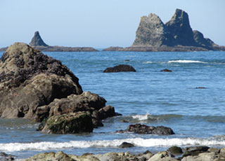
Social scientists are now studying how people use, and depend on, special and protected coastal areas - to reduce potential conflicts between user groups, and plan for sustainable use by constituents.
In FY15, NOAA's National Centers for Coastal Ocean Science (NCCOS) scientists surveyed the adult population in Puerto Rico and Hawaii to assess their use of coral reef resources, knowledge of threats to coral reefs, and support for management strategies used to protect reef ecosystems. In the U.S. Virgin Islands, occupational divers shared their expert knowledge of coral reefs in the region as part of an online, map-based survey conducted by NCCOS. The information the divers provided is being incorporated into a decision-support tool that will help natural resource managers identify priority reefs for management actions.
Additionally, NCCOS provided managers of the Mission Aransas National Estuarine Research Reserve in Texas with a report that identifies what the reserve's visitors and other stakeholders value about the reserve. They assessed the perceived value of the Olympic Coast National Marine Sanctuary in Washington, addressing how values might change if sanctuary resources were degraded by stressors like coastal development and climate change.
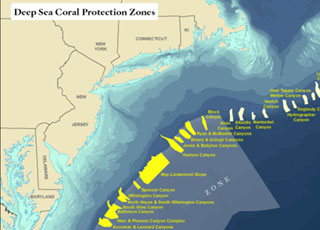
In 2015, NOAA's National Centers for Coastal Ocean Science (NCCOS) models, mapping products, and spatial analyses of deep-sea coral ecosystems informed a near-unanimous vote by the Mid-Atlantic Fishery Management Council (MAFMC) to protect more than 38,000 square miles of seafloor, stretching from New York to Virginia, from bottom fishing activities. The detailed spatial and scientific information provided by NOAA scientists enabled stakeholders to reach a broad consensus on proposed boundaries, leading to an outcome that both protects deep-sea corals and minimizes potential impacts to fisheries.
Also in 2015, in the Florida Keys National Marine Sanctuary, NCCOS scientists assessed the ecological impacts of management alternatives proposed by the Florida Keys National Marine Sanctuary Advisory Council. The assessment, along with related mapping products and human-use information developed by NCCOS, will support zoning and conservation decisions based on the best-available and most comprehensive science.
NOS uses its online presence to reach the ocean-interested public. Traffic to the NOS website increased 25.5% during FY 2015 compared to FY 2014. The number of Facebook "likes" grew more than 20% (from 52,640 to 64,413) and the number of Twitter followers grew more than 25% (from 101,807 to 129,480). During its 30-day National Ocean Month campaign, NOS reached more than 1 million users on Facebook. NOS continues to explore new platforms to reach a greater audience. In March, NOS completed its first Reddit Ask Us Anything with two scientists on an expedition in the Caribbean aboard the NOAA Ship Nancy Foster. The session generated more than 200 questions and was upvoted 89% of the time. In June, NOS launched a presence on Instagram, which is growing steadily.
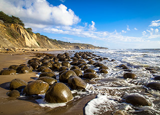
Cordell Bank and Gulf of the Farallones national marine sanctuaries more than doubled in size on June of 2015. As a result of the expansion, Gulf of the Farallones National Marine Sanctuary is now known as Greater Farallones National Marine Sanctuary. The expansion is based on years of public comment and research by NOAA and its scientific partners that identified the nutrient-rich upwelling zone originating off Point Arena and flowing south into the original sanctuaries as one of the most productive in North America. The area supports a vast array of sea life including whales, seals, dolphins, sea lions, seabirds and white sharks.
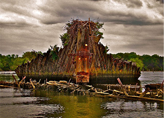
NOAA’s Office of National Marine Sanctuaries received the first nominations of places for consideration as potential new national marine sanctuaries. After an extensive public process, NOAA launched a new, locally driven sanctuary nomination process in June 2014. NOAA is reviewing submitted nominations to determine whether they successfully meet the national significance criteria and management considerations described in the sanctuary nomination process. As of July 2015, NOAA has determined the nominations for Mallows Bay – Potomac River (Maryland) and Lake Michigan (Wisconsin) have met the criteria. The successful nominations are entered into the inventory for consideration by NOAA for national marine sanctuary designation. Sanctuary designation is a separate public process that by law, is highly public and participatory, and often takes several years to complete.
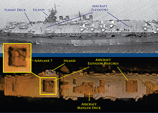
NOAA, working with private industry partners and the U.S. Navy, confirmed the location and condition of the USS Independence, the lead ship of its class of light aircraft carriers that were critical during the American naval offensive in the Pacific during World War II. The Independence rests upright in 2,600 feet of water off California’s Farallon Islands. The story of the USS Independence generated more than 13,400 news stories and more than 900 million story impressions. NOAA’s Office of National Marine Sanctuaries’ (ONMS) social media posts about the Independence resulted in 1,924 Twitter engagements and 4,732 Facebook likes, comments and shares. A team of researchers led by ONMS also discovered two significant vessels from World War II’s Battle of the Atlantic. The German U-boat 576 and the tanker Bluefields were found approximately 30 miles off the coast of North Carolina. Lost for more than 70 years, the discovery of the two vessels, in an area known as the Graveyard of the Atlantic, is a rare window into a historic military battle and the underwater battlefield landscape of WWII.

In support of the Administration's priorities related to promotion of outdoor recreation and tourism, NOAA’s Office of National Marine Sanctuaries (ONMS) coordinated a series of National “Get into Your Sanctuary" activities in June 2015 to encourage public awareness of sanctuaries as iconic destinations. Every sanctuary in the country conducted social media outreach during the month of June to promote corresponding National “Get into Your Sanctuary” Day events that occurred from June 27-28th, 2015. The events were also featured as part of Great Outdoors Month and involved opportunities for the public and Members of Congress to “get into” their sanctuaries. Sites across the sanctuary system welcomed more than 3,700 people to public activities.
ONMS social media channels used the hashtag #VisitSanctuaries to highlight recreational activities that sanctuary visitors can responsibly enjoy and share messages about how place-based conservation can contribute to sustainable tourism. The #VisitSanctuaries hashtag reached 914,247 Twitter users throughout the month of June.
NOAA’s Office for Coastal Management has developed three new green infrastructure products are helping coastal communities use natural and nature-based systems to absorb and filter excess water and reduce flooding. These new offerings include an interactive animation that illustrates how green infrastructure can help protect communities from storm impacts; a guide for spatial analysts who want to incorporate green infrastructure into mapping efforts; and a cost-benefits process that people are using to determine what green infrastructure strategies make the most sense for their community. These additions join other products featured on the green infrastructure section of the Digital Coast website.
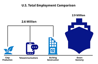
Understanding the value of the ocean is a crucial component of community decision making, yet the economic data we need are not always readily available or easy to understand. NOAA’s ENOW (Economics: National Ocean Watch) data were developed in response to this need. A 2012 fact pulled from the website, for instance, says the U.S. ocean and Great Lakes economy grew by 10.5 percent in real gross domestic product (GDP)—more than four times as fast as the U.S. economy as a whole. More facts, as well as the latest data and trends, soon will be online in the NOAA Report on the U.S. Ocean and Great Lakes Economy. These and other economic-centered products are available from NOAA’s Digital Coast, which is provided by the NOAA Office for Coastal Management.
During the past year more than 10,000 acres of coastal lands were acquired or designated for long-term protection through the Coastal Zone Management Program. State partners executed these actions, in many cases by creating a conservation easement. These same programs also constructed or enhanced 385 public access points. Giving people access to the nation's natural resources is an important and popular part of the local and national coastal management effort.

NOAA scientists continue to deliver products and tools to help resource managers predict and prepare for the ongoing and destructive global coral bleaching event. In early 2015, based on data from satellites and climate models, NOAA scientists sounded the alarm that corals in the Pacific and other regions were at risk for bleaching. Months later, more warnings followed for coral reefs in much of the Northern Hemisphere, which prompted NOAA to declare the onset of the third recorded global coral bleaching event. In addition to forecasting thermal stress events and bringing them to worldwide attention through the media, the NOAA Coral Reef Conservation Program released its strategy to reduce the impact of climate change and ocean acidification to coral reefs, as well as a list of the top 10 things resource managers can do to prepare and respond to bleaching events. Researchers also contributed to a study that projects the impacts of climate change on the world's oceans and the goods and services they provide. NOAA has identified climate change as a key global threat to coral reef ecosystems. The Coral Program works across federal agencies and with local, regional, and international partners to coordinate efforts to address the impacts of climate changes and foster more resilient coral reefs.
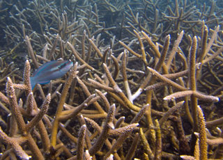
Florida's Biscayne Bay and Puerto Rico's Northeast Marine Corridor and Culebra Island have been named as NOAA Habitat Focus Areas—places where the agency can maximize its habitat conservation investments and management efforts to benefit marine resources and coastal communities. Biscayne Bay is threatened by harmful algal blooms, and an investigation of water quality conditions that promote these blooms is needed to reduce nutrient inputs where possible. The Northeast Marine Corridor and Culebra Island are home to a diversity of coral reef species, mangroves, seagrass beds, and other habitat types. NOAA's Coral Reef Conservation Program is actively working with teams across NOAA line offices and partners in Puerto Rico to develop a strategy to address the top threats to the region's unique habitats. The recognition of Biscayne Bay and the Northeast Marine Corridor and Culebra Island as Habitat Focus Areas under NOAA's Habitat Blueprint allows the agency to maximize its habitat conservation efforts in these areas. The Coral Reef Conservation Program is leading much of NOAA's efforts to support ridge-to-reef science and place-based conservation in both areas, and Puerto Rico in particular.
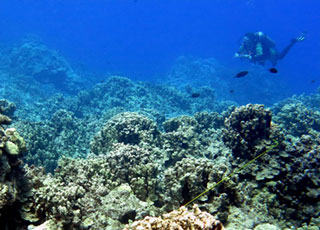
NOAA scientists and partners in the Commonwealth of the Northern Mariana Islands developed innovative techniques to evaluate coral reef resilience. An assessment of 78 coral reef sites off Saipan, Tinian, Aguijan, and Rota revealed that Saipan, the most populated island, is home to the most resilient reef sites in the study. Sites off Rota, the most isolated island, ranked low in terms of resilience. Study findings were used to identify priority sites for six types of management actions including: conservation, land-based sources of pollution reduction, and fishery management and enforcement. The data also indicate that the presence of herbivores, coral recruitment and the exchange of coral and fish larvae between islands are key drivers of resilience. Reefs in the commonwealth experienced widespread bleaching in 2013 and 2014, but were spared during the 2015 global bleaching event. The assessment results supported by the NOAA Coral Reef Conservation Program provide an innovative tool to help officials implement effective resilience-based management strategies. The methodology has global relevance as efforts move increasingly toward managing for resilience. The commonwealth is home to diverse coral reef ecosystems that provide residents with many goods and services. This approach to evaluating reef resilience will provide much-needed guidance on where and what type of conservation actions will ensure the commonwealth has healthy reefs in the future.
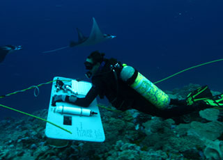
Scientists continued to collect biological, climatic, and socioeconomic data to measure changes in U.S. coral reef ecosystems as part of the National Coral Reef Monitoring Program. In the U.S. Pacific Islands of American Samoa and the U.S. Pacific Remote Islands Marine National Monument, NOAA scientists conducted hundreds of fish and benthic surveys and recovered and re-deployed instruments to assess impacts of ocean acidification and warming. In the Atlantic, experts gathered similar data at sites in the U.S. Virgin Islands and the Flower Garden Banks. Social science researchers focused on the connections between coral reef ecosystems and the people, their communities and economies by completing resident surveys in Hawaii and Puerto Rico. Teams established climate data collection sites in the Gulf of Mexico and the Atlantic and Pacific Oceans to support modeling efforts and to identify areas of reef resilience and vulnerability. Satellite remote sensing provided data across all U.S. reef areas, filling gaps between filed sampling sites. The National Coral Reef Monitoring Program is an integrated and focused monitoring effort with partners across the U.S. and its territories. Outcomes will help managers, decision makers, and communities better understand the condition of their resources and take effective place-based conservation actions. This effort is supported by the NOAA Coral Reef Conservation Program.
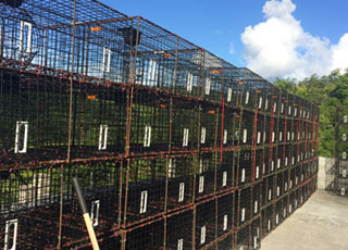
Fish traps are an economically important tool for local fishers in the U.S Virgin Islands, but they are generally considered a non-selective gear with high bycatch. Scientists and fishers cooperatively designed a more selective and efficient fish trap that reduces bycatch. NOAA and the St. Thomas Fishermen's Association partnered to conduct a series of experiments resulting in a final vent design that successfully maintained or improved catch rates while reducing capture of non-target and undersized species. This includes herbivorous species that, by grazing algae on the reef, play an important role in maintaining ecosystem balance and resilience. The unwanted fish escaped underwater before the traps were hauled to the boat, so the fishers spent less time handling unwanted fish before resetting their traps. Fishers across St. Thomas are adopting the new design and sharing results with neighboring fishing communities. This work, funded by the NOAA Coral Reef Conservation Program and others, demonstrates the effectiveness of scientists and fishers working together to come up with real-world solutions to fisheries challenges.
 An official website of the United States government.
Here's how you know we're official.


