The National Geodetic Survey (NGS) hosted the 2015 Geospatial Summit in Arlington, Virginia, to share plans to release new geodetic datums in the year 2022. Huge benefits are associated with the adoption of the new datums. The new vertical reference system is estimated to produce $522 million in annual economic benefits to the nation, with approximately $240 million saved from improved floodplain management.
During the Summit, NGS discussed the tools available for its customers to transition to the new datums and shared strategies to enable the mapping and surveying communities to prepare well in advance of the changes. Surveyors; GIS professionals; federal, state, and local government agencies; and others then had the opportunity to comment and ask questions regarding the effect the new datums will have on their work.

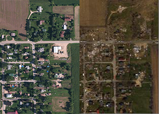
FY15 is the first year the National Geodetic Survey (NGS) has collected aerial oblique imagery prior to disastrous events (i.e. hurricanes, tornadoes, oil spills, etc.). This provides two major benefits: it covers the shoreward-facing side of structures and other infrastructure not visible with traditional aerial photography, and it allows us to photograph coastal damage much more quickly than traditional methods. In a natural disaster, emergency responders can compare georeferenced oblique imagery from before and after the event to help them make time-critical decisions for response and recovery efforts.
NGS collected aerial imagery following two major natural disasters in FY15. In January, NGS collected aerial damage assessment imagery in the aftermath of the Nor'easter that blanketed the region in snow and caused significant storm surge along the New England coast. The following April, more than 2,800 images were collected in areas most impacted by multiple tornado strikes in Northern Illinois to support Illinois’ Tornado Emergency. Aerial imagery provides a cost-effective way to better understand the damage sustained to both property and the environment and is a crucial tool used by federal, state, and local officials and the public.

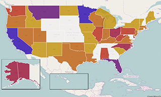
The National Geodetic Survey (NGS) initiated a 2015 GPS on Bench Marks Campaign as part of National Surveyors Week. The campaign increased awareness about professional surveying while improving the National Spatial Reference System (NSRS)—the coordinate system that provides latitude, longitude, height, scale, gravity, and orientation for the United States and delivers over $2.4 billion in potential annual benefits to the U.S. economy.
NGS will use data received from the campaign to improve the next vertical positioning model and facilitate conversions to the new vertical datum in 2022. While observations made with survey-grade equipment were preferred, NGS encouraged geocachers and anyone with a GPS-enabled phone or hand-held device to join in.
To promote the campaign, NGS held a webinar for over 400 attendees and developed a web map/planning tool. The event produced noteworthy news stories in industry-affiliated press and an article in the Wall Street Journal.

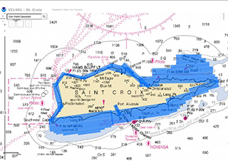
The National Geodetic Survey (NGS) completed a three-week project in St. Croix, U.S. Virgin Islands to collect airborne topographic-bathymetric (“topo-bathy”) light detection and ranging (lidar) data and imagery of the shoreline, using the NOAA Twin Otter aircraft. The survey supports data requirements for both NOS’s Office of Coast Survey (OCS) and the National Centers for Coastal Ocean Science (NCCOS) and will help update charted depths for most of the island. The last survey of the island was acquired via single-beam sonar in 1980.
Topo-bathy lidar acquires land values—or heights—and depths under the water surface. It is used to supplement hydrographic survey data for updating NOAA Nautical Charts and to enable NCCOS to create habitat maps.

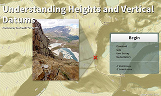
In a FY15 collaborative effort between the National Geodetic Survey (NGS) and The COMET® Program, the first in a series of training lessons for scientists, engineers, and mapping professionals was developed and released. The lesson provides a basic understanding of vertical datums and how to choose the appropriate datum for a given application. A conceptual understanding of ellipsoidal, geopotential, and tidal datums was also introduced.
Accurate heights are vital for emergency preparedness, floodplain mapping, restoration, urban planning, and more. This training lesson represents NGS’s commitment to engaging and educating its customers for a successful transition to the new vertical datums NGS plans to release in 2022. This interactive presentation provides participants with knowledge to better understand the impact of the new datums. NGS has received positive feedback and plans to add to its educational library.
 An official website of the United States government.
Here's how you know we're official.


