NOAA’s Office of Response and Restoration (OR&R) is tasked with responding to oil spills, chemical accidents, and other emergencies in coastal areas. OR&R’s expertise spans oceanography, biology, chemistry, and geology, allowing the response team to estimate oil and chemical trajectories, analyze chemical hazards, and assess risks to coastal animals, habitats, and important commercial and recreational areas. OR&R teams, led by regional scientific support coordinators, provide scientific support to the U.S. Coast Guard for spills in coastal waters.
$114M Recovered for Restoration in Five States
SUPPORTS NOS PRIORITY: CONSERVE, RESTORE, AND CONNECT.
This year, OR&R’s Assessment and Restoration Division and partners recovered $114 million through pollution settlements for restoration, including for three oil spills and three hazardous waste (Superfund) settlements. These included:
$73.5 million to build a riverside park in East Newark, New Jersey, to create a safe green space for underserved urban communities disproportionately impacted by industrial pollution.
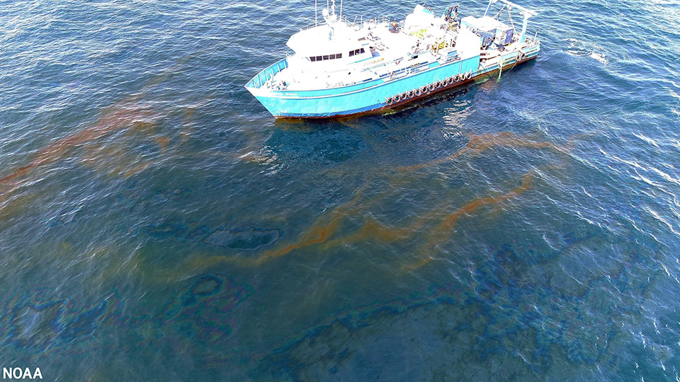
$16.5 million to restore the Gulf of Mexico from the Taylor Energy oil spill — the longest offshore oil spill in United States history.
$15.3 million to restore coastal habitats and marine mammals in Texas after an oil spill in the Port of Houston.
$5.3 million to restore fisheries and marsh in Louisiana after an oil spill near New Orleans.
$2.5 million to remove invasive mangroves in Pearl Harbor in Oahu, Hawaii, after industrial pollution.
$500,000 to restore an urban waterway in Pennsylvania for oysters, migratory fish, and birds.
: A research vessel at the Taylor Energy oil spill site in July 2022.
New Marine Debris Projects Awarded, More Funding Announced
SUPPORTS NOS PRIORITY: CONSERVE, RESTORE, AND CONNECT.
Marine debris is a pervasive national and global problem that harms wildlife, navigation safety, ecosystem health, and the economy. This year, OR&R’s Marine Debris Program provided approximately $3.7 million in federal funds to 14 projects that will remove and prevent marine debris. The awards include funding appropriated through the United States-Mexico-Canada Agreement Implementation Act. Nonfederal matching contributions bring the total investment in these projects to approximately $7.8 million.
The Bipartisan Infrastructure Law provided $150 million to NOAA for marine debris assessment, prevention, mitigation, and removal for FY 2022-2026. In September, the program awarded $1 million in Bipartisan Infrastructure Law funding to support marine debris removal in the Papahānaumokuākea Marine National Monument, enabling the removal of over 500 metric tons of debris in coming years. In June, the program announced a $56 million competitive funding opportunity using Bipartisan Infrastructure Law funding to remove large marine debris and use proven interception technologies to capture marine debris. The awards will be announced in early 2023.
Better Disaster Preparedness for Coastal Communities
SUPPORTS NOS PRIORITY: COASTAL RESILIENCE | NEW BLUE ECONOMY | CONSERVE, RESTORE, AND CONNECT.
Partnerships are critical to NOAA’s success in disaster preparedness. This year, OR&R’s Disaster Preparedness Program embarked on a new partnership with the National Sea Grant Office in NOAA’s Office of Oceanic and Atmospheric Research. Sea Grant programs are well positioned to support their communities given their proximity to and familiarity with the needs of those they serve.
OR&R and Sea Grant established a new funding opportunity for their programs that would improve disaster preparedness within coastal communities. A new competition will provide funding for projects that address preparedness gaps or needs that would enable the community to reduce disaster impacts and reach recovery more quickly. Sea Grant announced the selection of three projects led by Hawaii, MIT, and Wisconsin Sea Grant programs that will receive a total of $540,000 over two years. These projects will benefit vulnerable communities by helping them plan for, respond to, and recover from flooding, sea level rise, and oil spill impacts to aquaculture.
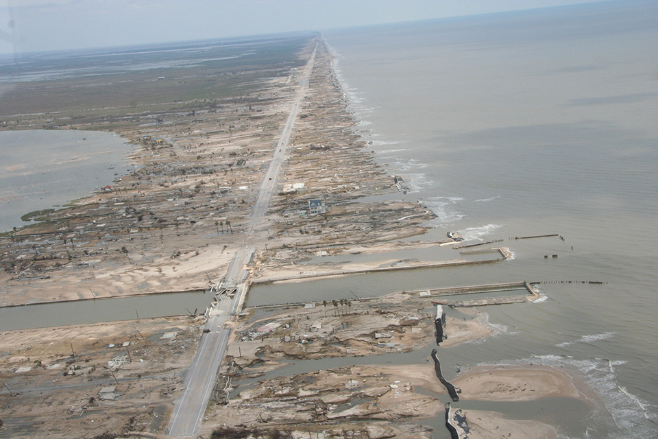
This aerial image shows devastation in Bolivar Peninsula, Texas, following Hurricane Ike in September 2008. Disaster preparedness projects help communities prepare for and respond to events like hurricanes.
Updating Data, Increasing Effectiveness in the Great Lakes
SUPPORTS NOS PRIORITY: COASTAL RESILIENCE | NEW BLUE ECONOMY | CONSERVE, RESTORE, AND CONNECT.
As part of an emphasis on freshwater spill preparedness in the Great Lakes region, OR&R launched a full refresh of Environmental Sensitivity Index (ESI) data in the area, carried out preparedness events, and initiated new partnerships.
With support from the U.S. Coast Guard, data and maps for Lake Erie were updated in FY 22. Next, the team will work on refreshed ESI data and maps for Lake Ontario, to be followed by lakes Michigan and Huron, leveraging generous support from the Great Lakes Restoration Initiative. In total, the data covers 2,000 miles of shoreline, biology, and socioeconomic data. The funding will also go toward creating a holistic, “enterprise solution” for ESI data and resources. These efforts will improve coastal resilience in lakes where shipping and pipelines carry nearly 23 million gallons of oil per day.
OR&R also led complimentary webinars, trainings, workshops, and tabletop exercises in 2022 to enhance NOAA’s and our partners’ readiness posture for oil spill response and environmental threats in the Great Lakes. OR&R established new agreements with the Coast Guard National Center of Expertise for Great Lakes Oil Spill Preparedness and Response for projects to enhance data management, detect oil in ice environments, improve uncrewed systems applications, and transition research into operations.
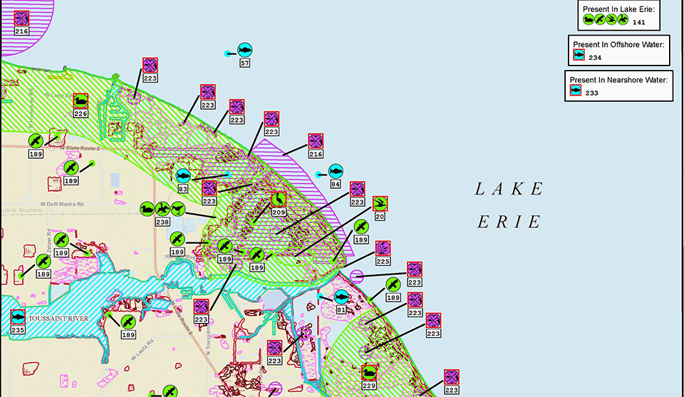
This ESI map, produced in 2022, shows sensitive biological features for a section of the shoreline of Lake Erie. Icons indicate the presence of different species of marine life and sensitive habitats. ESI maps also show human use sites, such as protected areas, aquaculture sites, cultural heritage locations, and recreational areas.
Oil on Ice Research for a Changing Arctic
SUPPORTS NOS PRIORITIES: CONSERVE, RESTORE, CONNECT | COASTAL RESILIENCE
In FY 22, scientists from OR&R and the U.S. Coast Guard conducted research at three locations to test uncrewed aircraft systems (aerial drones) and remotely operated vehicles (underwater) sensors to characterize oil on water in ice environments. At the Cold Regions Research and Engineering Laboratory facilities in New Hampshire, scientists created oil slicks, with and without ice, in a test pool with a frozen ice surface, then simultaneously measured them from above and below. This allowed researchers to test their ability to see oil in icy water and to verify the accuracy of these tools.
The team then traveled to Alaska to characterize uncertainties, strengths, and limitations of these technologies under real-world environmental conditions. In Olitok, Alaska, the team confirmed their ability to use these tools to produce consistent data and upload it into NOAA’s Emergency Management and Response Application (ERMA®) for use by oil spill responders. Scientists then collected data aboard a Canadian Coast Guard vessel to map Arctic ice in water, identify complicating factors for drone sensors, and use the sensors to identify sensitive areas and resources. Collectively, this work bolsters resilience to oil spills and NOAA’s oil spill response capabilities in a changing Arctic.
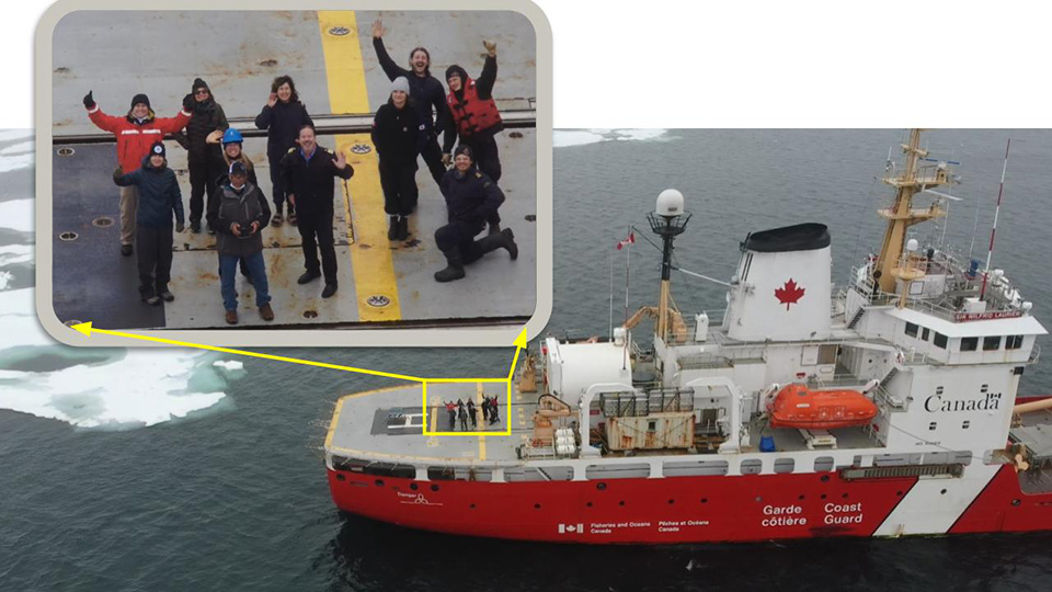
The team used aerial drones and underwater remotely operated vehicles to better understand oil spills and response in the Arctic. The drone also captured photos like this one, of the science team, captain, and crew onboard the Canadian Coast Guard icebreaker Sir Wilfrid Laurier.
 An official website of the United States government.
Social