NOAA’s Office for Coastal Management (OCM) works to keep the nation's coasts safe from storms, rich in natural resources, and economically strong. The office administers the National Coastal Zone Management Program, the Coral Reef Conservation Program, the Digital Coast, and the National Estuarine Research Reserve System.
NOAA Designates Connecticut National Estuarine Research Reserve
SUPPORTS NOS PRIORITIES: CONSERVE, RESTORE, AND CONNECT
In January 2022, NOAA and the state of Connecticut designated the Connecticut National Estuarine Research Reserve. This reserve, located in the southeastern part of the state, is the 30th site in the National Estuarine Research Reserve System and the first in Connecticut, adding over 52,000 acres to the national system. The reserve will facilitate new partnerships and collaborative research to improve coastal management, local sustainability, and ecosystem resilience. The Connecticut Reserve advances the America the Beautiful initiative, which commits to conserving at least 30% of U.S. lands and waters by the year 2030. The reserve will be managed as a partnership between NOAA and the state of Connecticut.
The Connecticut Reserve — the 30th National Estuarine Research Reserve and the first in the state — added over 52,000 acres to the national system.
NOAA Coastal Resilience Funds Deliver Millions to Coastal Communities
SUPPORTS NOS PRIORITIES: CONSERVE, RESTORE, AND CONNECT
In August 2022, OCM and the National Fish and Wildlife Foundation (NFWF) announced $7.7 million in initial awards for FY 2022 National Coastal Resilience Fund grants, using funding from the Bipartisan Infrastructure Law, to support ongoing natural infrastructure projects in seven states. These grants will support design and implementation of projects to enhance the resilience of coastal communities and improve habitats for fish and wildlife. The grants will leverage more than $3 million in matching contributions, for a total of $11.1 million. This year, NOAA and NFWF worked to award an early slate of grants so communities experiencing increasing impacts from coastal hazards would have funding for resilience projects.
Earlier in 2022, NOAA and NFWF’s Emergency Coastal Resilience Fund invested $25.2 million in projects that increase the resilience of coastal communities within federally declared disaster areas impacted by hurricanes and wildfires in 2020 and 2021. Across the federal budget, emergency supplemental funds, and Bipartisan Infrastructure Law funding — including National Coastal Resilience Fund projects announced in November 2021 — these grants have invested over $134 million to increase resilience in coastal communities.
The National Coastal Resilience Fund supports projects that enhance the resilience of coastal communities, like this dune restoration project in Puerto Rico.
NOAA Unveils New and Improved Coastal County Snapshots
SUPPORTS NOS PRIORITY: COASTAL RESILIENCE
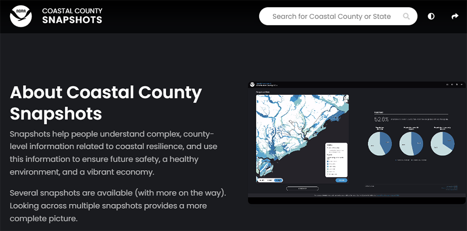
NOAA released a new and improved version of the Coastal County Snapshots, one of its most popular tools. The snapshots combine complex, county-level data to create automated charts, graphics, and information. Users, including community leaders, can choose their area and topic of interest and use this information to understand community vulnerability and to address these challenges through good planning initiatives. Topics include flood exposure, marine economy, total economy, and exposure to sea level rise. The sea level rise snapshot incorporates the most up-to-date sea level rise projections as published from the 2022 Sea Level Rise Technical Report. It also allows the user to explore the projections from the previous report. The Coastal County Snapshots are part of the Digital Coast, a constituent-led information platform that includes data, tools, and training. It is the proverbial “one-stop shop” for the nation’s coastal management community.
The Digital Coast’s improved Coastal County Snapshots turn complex data into easy-to-use sources of information, allowing users to access valuable data on their area and topic of interest, including sea level rise exposure, marine economy, and more.
NOAA Updates Digital Coast Tools
SUPPORTS NOS PRIORITY: COASTAL RESILIENCE
OCM expanded and updated several of its most popular Digital Coast tools. A data update to the Sea Level Rise Viewer — a longtime favorite that helps communities visualize potential impacts of coastal flooding and make informed decisions — included the latest sea level rise projections, released earlier this year. In addition to the regular data, there are seven new digital elevation models available for download, covering areas in Alabama, Florida, New Jersey, Puerto Rico, and the U.S. Virgin Islands. Areas with older and lower resolution data were also updated.
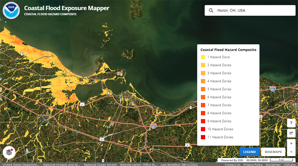
The Digital Coast team also expanded the Coastal Flood Exposure Mapper to cover coastal areas along the entire Great Lakes. The mapper now includes the East and West coasts, Gulf of Mexico, Great Lakes, and islands in the Pacific and Caribbean. The tool creates a collection of user-defined maps that show the people, places, and natural resources exposed to coastal flooding. In addition, the tool provides guidance for using these maps to engage community members and stakeholders in flood mitigation planning. The tool is another example of products NOAA provides as an authoritative source of climate data and services.
NOAA made updates and improvements to several of its popular Digital Coast tools, including the Sea Level Rise Viewer and Coastal Flood Exposure Mapper, both of which serve as authoritative sources of climate data and services.
 An official website of the United States government.

Social