NOAA’s National Geodetic Survey (NGS) provides the framework for all positioning activities in the nation. The foundational elements of latitude, longitude, elevation, and shoreline information impact a wide range of important activities.
Canada, U.S. Update International Great Lakes Datum
SUPPORTS NOS PRIORITY: COASTAL RESILIENCE | NEW BLUE ECONOMY
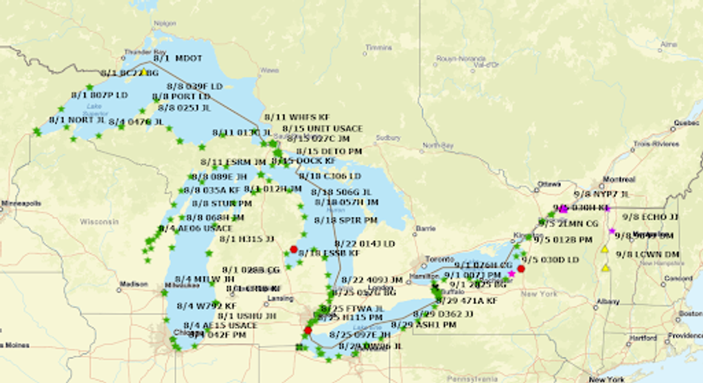
U.S. and Canadian surveyors were in the Great Lakes region for a six-week project collecting Global Navigation Satellite Systems (GNSS) data at over 350 locations as part of an update to the International Great Lakes Datum (IGLD). The IGLD is the common reference system used to measure water level heights throughout the Great Lakes‐St. Lawrence River System, providing support for marine navigation, water level regulation, water management, surveying, mapping, and shoreline-use planning. Updates to the IGLD occur every 25 to 30 years to account for the movement of the Earth’s crust. This is the first update to use GNSS data. Updating the IGLD will benefit its many applications, including lake level forecasting and hydroelectric power regulation, as well as water level measurements.
Map of benchmarks resurveyed on the American side of the Great Lakes for the 2022 update of the International Great Lakes Datum.
NOAA, Census Bureau Mark 2020 Center of Population
SUPPORTS NOS PRIORITIES: CONSERVE, RESTORE, AND CONNECT
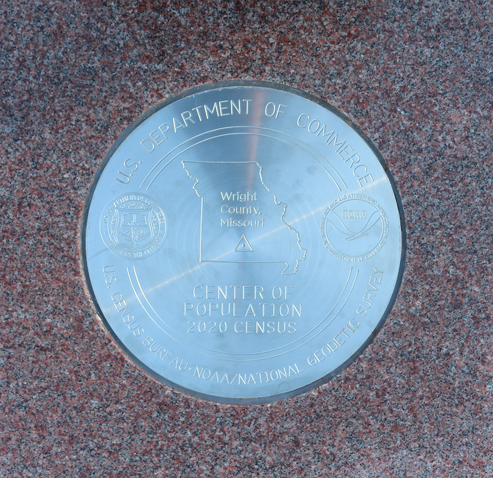
NGS and the Census Bureau dedicated a commemorative survey mark designating Hartville, Missouri, as the 2020 center of population. The center of population is where an imaginary, flat, weightless, and rigid map of the United States would balance perfectly if all residents were of equal weight. This place represents the average location of where people in the United States live. “The 2020 center of population commemorative mark is a tribute to Hartville, the surveying community, and the science of geodesy,” said NGS Director Juliana Blackwell. “The commemorative mark represents the latest stop on the center of population trail, and its exact location and coordinates will be added into the National Spatial Reference System for use by surveyors, geocachers, and geospatial enthusiasts for decades to come.
The 2020 center of population commemorative survey mark was embedded in a 2,000-pound rose granite monument in Hartville, Missouri.
VDatum Continental West Coast Regional Model Update
SUPPORTS NOS PRIORITY: COASTAL RESILIENCE | NEW BLUE ECONOMY
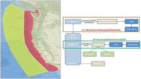
Flowchart and map of the coastline shows the areas affected by the VDatum update.
In FY 2022, NGS updated parts of the VDatum software tool, which converts elevation data from various sources into a common reference system. The Continental United States West Coast Regional Model was updated this year, covering what were previously three separate regional models. Additional separation of the model into 13 new divisions allows for enhanced resolution in detailed areas and the capture of smaller inland water bodies, such as in the Puget Sound, along the Oregon and California coasts, and the San Francisco Bay. The area further offshore was separated to provide additional coverage, but also allow for reduced resolution of the grid.
This is the first regional model to be upgraded in a series of four larger scale models for VDatum to help the program become more agile with frequency of updates, ingesting new data, and fixing any issues. Utilizing a roadmap that traverses through the international reference frame and experimental geoid model assists in preparation for transitioning to the modernized National Spatial Reference System in the near future.
Geospatial Industry Adopts GVX File Format
SUPPORTS NOS PRIORITY: NEW BLUE ECONOMY
NGS introduced a new standard file format, known as GVX, for exchanging GNSS vector data that is derived from different GNSS surveying methods and equipment. Hardware manufacturers for the geospatial industry are adopting the GVX standard. Several companies already offer tools to export in this file format, with more in development. The GVX format is becoming the standard way to efficiently share data from GNSS equipment manufacturers. GVX supports all types of GNSS vectors, including those from a real-time kinematic survey or from baseline post-processing. GVX files can be uploaded to NGS's free online software, OPUS Projects 5.0. From OPUS Projects, the data can be submitted to NGS, boosting productivity and improving the nation's geodetic infrastructure.
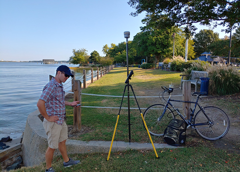
Measurement of a bench mark using real-time kinematic surveying equipment in Norfolk, Virginia.
NGS Co-locates with CO-OPS in Chesapeake
SUPPORTS NOS PRIORITY: COASTAL RESILIENCE
In FY 22, NGS’s Field Operations Branch moved to a new location in Chesapeake, Virginia, sharing space with NOAA's Center for Operational Oceanographic Products and Services (CO-OPS) Field Operations Division. The move was beneficial in many ways: The former location was an aging facility at high risk of impact from coastal storms, recurrent tidal flooding, hurricanes, and high-volume rain events. The new location provides a modern office, ample training room, and a more efficient warehouse that immediately improved the productivity of field operations and the security and safety of personnel and equipment. In addition, NGS and CO-OPS staff working in the same location led to enhanced relationships, as well as improved coordination and communication. This closer relationship has included knowledge-sharing on GNSS surveying, leveling, and water level stations — most notably for the planning and scheduling adjustments needed to make the International Great Lakes Datum survey campaign a success. Both field teams are already moving forward with new ideas and plans on how to work together more often. The move also reduces carbon footprint, removes storm threats to the facility, and allows both operational groups to work together.
 An official website of the United States government.