Center for Operational Oceanographic Products and Services
NOS Fiscal Year 2022 Year in Review
NOAA’s Center for Operational Oceanographic Products and Services (CO-OPS) is the authoritative source for accurate, reliable, and timely tides, water levels, currents, and other vital coastal oceanographic and meteorological information.
CO-OPS Improves its Coastal Hazards Products
SUPPORTS NOS PRIORITIES: COASTAL RESILIENCE
CO-OPS significantly enhanced its suite of coastal hazards products in 2022, updating both inundation and sea level tools. As part of these efforts, CO-OPS recalculated relative sea level trends for more than 100 long-term National Water Level Observation Network (NWLON) stations and developed an interactive Sea Level Trends map in collaboration with Climate.gov. This stand-alone tool integrates dynamic trend plots to show changes in sea level rise across NOAA’s water level network and to help coastal decision-makers better visualize near- and long-term inundation risks, from storm surge to high tide flooding. In the wake of record and near-record Great Lakes water levels in 2019 and 2020, CO-OPS added 50 Great Lakes stations to its Coastal Inundation Dashboard. The map-based tool allows users to view water levels in real time and was invaluable for monitoring coastal flooding during Hurricane Ian and Typhoon Merbok. NOAA’s State of High Tide Flooding and Annual Outlook report also received a geospatial facelift, transitioning from a static PDF to an interactive web map that displays local flooding predictions alongside sea level trends from the 2022 Interagency Sea Level Rise Technical Report. With these data and tools, CO-OPS enables coastal communities to successfully plan for and mitigate risk from changing ocean conditions.
NOAA’s Sea Level Trends map shows how local sea level has changed across more than 100 CO-OPS water level stations.
PORTS® Program Implements Major Expansions and Additions
SUPPORTS NOS PRIORITY: NEW BLUE ECONOMY
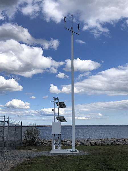
Davisville station, which is now part of the Narragansett PORTS, provides real-time data on wind, air temperature, barometric pressure, and relative humidity.
CO-OPS substantially expanded its Physical Oceanographic Real-Time Systems (PORTS®) by enhancing seven existing systems and establishing its 37th PORTS around Naval Base Kitsap in Washington. Developed in partnership with the U.S. Navy, the new Kitsap system equips Navy personnel and local mariners with real-time water level, current, and meteorological information critical for planning and responding to changing oceanographic conditions. This will greatly increase the navigation safety of vessels entering and exiting Puget Sound and traversing Rich Passage and Hood Canal. In the Gulf of Mexico, the Corpus Christi PORTS finalized a major expansion with the addition of new water level, currents, and visibility stations. Other PORTS across the country completed additions and updates, including new wind sensors at Jacksonville PORTS; a new offshore current meter at Lake Charles PORTS; a new meteorological station at Narragansett PORTS; and new meteorological and salinity sensors for the Portsmouth PORTS. Both the Lower Mississippi and Cape Cod PORTS integrated data from newly installed Coastal Data Information Program wave buoys. Real-time oceanographic and meteorological observations provided by NOAA PORTS help ensure safe navigation within U.S. waterways and represent a critical element of the nation’s data-driven blue economy.
Marine Channel Forecast System Launched in Mobile Bay
SUPPORTS NOS PRIORITY: PREPAREDNESS AND RISK REDUCTION
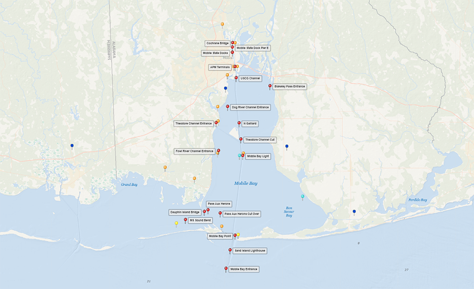
NOAA launched the Mobile Bay Marine Channels Forecast System, centralizing all of the region’s oceanographic and meteorological forecasts into one online location. Mobile Bay’s system is the second of its kind in the U.S. and expands the flagship 2017 Tampa Bay system into a new region in the Gulf of Mexico. The release represents the culmination of a yearlong collaboration between NOS and National Weather Service (NWS) weather forecast offices in Mobile/Pensacola and Tampa Bay. Ship pilots transiting Mobile Bay can use the new application to view all NOS water level and tidal current forecasts alongside 24-hour NWS weather forecasts for wind, rain, marine hazard alerts, and visibility at 19 locations along the seaport. In a region frequented by fog, this information is integral for scheduling routes and piloting safely during periods of low visibility. The forecast system launched at an opportune time, just months after the development of NOAA’s new Northern Gulf of Mexico Operational Forecast System and the expansion of Mobile Bay’s PORTS. Information provided by these three systems help ensure a flourishing U.S. economy and the safety of nearby coastal communities.
Pins on a map of Mobile Bay show the locations of 19 stations in the forecast system.
NWLON Infrastructure Upgrades Fill Critical Data Gaps
SUPPORTS NOS PRIORITY: COASTAL RESILIENCE
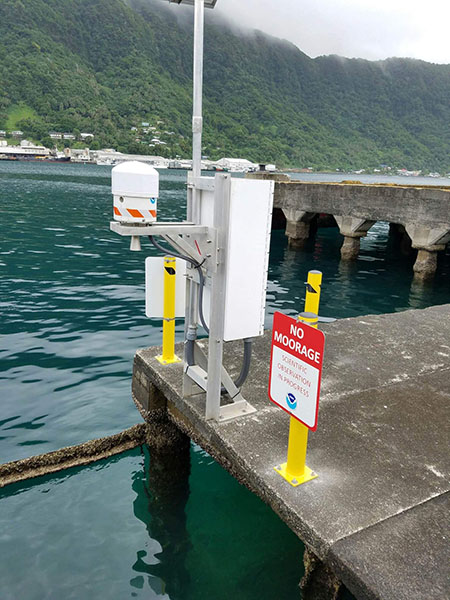
The NWLON station in Pago Pago, American Samoa, provides critical data for NOAA’s Tsunami Warning Center
Accurate, timely, and reliable water level data provided by the NWLON is critical for protecting life, property, and the environment nationwide. In 2022, CO-OPS performed repairs and replacements on NWLON stations to ensure they can withstand local environmental conditions and continue data dissemination when most needed. CO-OPS finalized construction of a reinforced, multi-pile “Sentinel of the Coast'' water level station at Dauphin Island, Alabama. The new station replaces a failing timber structure that was in operation since the 1980s and ensures real-time data is available for safe navigation and during coastal inundation events. In American Samoa, CO-OPS installed an emergency NWLON station on Tutuila Island at the Port of Pago Pago to replace a water level station removed for local construction. The station, along with other Pacific NWLON stations, provided NOAA’s Tsunami Warning Center with critical, one-minute tsunami data from the Tonga volcanic eruption in January to help warn local communities and other Pacific Island governments. It will continue to provide real-time water level data to the government of American Samoa to inform coastal resilience planning and protect American Samoans from climate hazards.
 An official website of the United States government.
Social