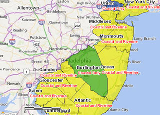
In FY 14, in response to post-tropical cyclone Sandy, a team of federal policy and science experts led by NOAA’s Office for Coastal Management created an interactive sea-level rise mapping and calculator tool to help people identify and prepare for flooding related to rising sea levels. Recognizing the need to inform Sandy-related rebuilding decisions, the tool was ready in a remarkably short time. The team’s efforts were recognized with the 2013 Presidential GreenGov Awards’ “Climate Champion” designation.
While climate change is a worldwide event, preparation for it is site-specific. NOAA’s Office for Coastal Management supports coastal management programs seeking adaptation measures that make the most sense for their particular situations. Examples include: Delaware, which signed an executive order requiring the incorporation of sea-level rise data when constructing state-funded projects, and the protection of green infrastructure that helps contain flood waters; Rhode Island, which created a guide to help homeowners understand climate change, erosion, and other natural and regulatory processes that may impact their property; Maryland, which issued a report with coastal construction and design guidelines to address the vulnerability of approximately 1,000 state-owned facilities in coastal areas; and Climate adaptation workshops held in Massachusetts, Rhode Island, New Hampshire, and Maine, which helped local leaders prepare for climate change challenges.

In FY 14, in response to post-tropical cyclone Sandy, NOAA’s Office for Coastal Management developed a new online tool called the Coastal Flood Exposure Mapper that gives coastal New York, New Jersey, Delaware, and Pennsylvania easy access to community-level flood information. The tool displays county-level data about shallow coastal flooding, flood zones, storm surge, sea level rise, and a composite view of flood hazards. An added bonus is the ability to include important data such as population centers, infrastructure, and evacuation routes. Maps can be downloaded or shared online. In addition to the Mapper helping make communities safer, it also helps them take actions to raise their scores in the National Flood Insurance Program’s community rating program. Plans are under way to expand the reach of the tool to include the rest of the East Coast and the Gulf of Mexico.
Restore America’s Estuaries, a NOAA Office for Coastal Management partner, submitted the first detailed methodology for quantifying real greenhouse-gas emissions for tidal wetlands and seagrass restoration. This groundbreaking work opens the door for tidal wetland and seagrass restoration projects that meet certain eligibility conditions to calculate net greenhouse gas benefits and generate carbon credits. Governments, industries, and private individuals can use carbon credits to offset damaging carbon emissions that they are generating. The work was made possible with funds from the National Estuarine Research Reserve Science Collaborative and NOAA’s Habitat Conservation and Restoration Center.

Understanding how land cover is changing is an important component of successful coastal management. While coastal communities have used NOAA’s land cover data for this purpose for more than 20 years, NOAA’s Land Cover Atlas, updated by the Office for Coastal Management in FY 14, makes it even easier for communities to access and understand the data. A fact that the updated Atlas uncovered is that 8.2 percent of the nation’s coastal and Great Lakes regions experienced land cover or land use changes from 1996 to 2011. That’s a total of 64,975 square miles—an area larger than the state of Wisconsin. Much of this change is related to new development. In FY 14, land cover data helped officials assess sea level rise hazards in Florida’s Miami-Dade County, determine high-risk areas for stormwater runoff in southern California, and find the best habitat restoration sites in two Great Lakes watersheds.

In the wake of events like post-tropical cyclone Sandy in October 2012, some coastal communities are showing a greater interest in engineered shorelines. NOAA’s National Estuarine Research Reserves in the Mid-Atlantic encouraged regional dialogue on the issue and began to identify ways to leverage existing resources for this purpose. Reserves in New York, New Jersey, and Delaware led workshops on the topic, where participants explored ways to implement ecologically enhanced shoreline projects and collaborated on the development of regional tools, resources, and guidance.
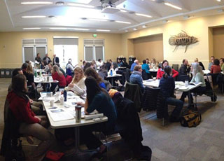
Building the capacity of coastal officials is the key to effective coastal management decisions. In FY 14, NOAA’s Office for Coastal Management updated several of its professional courses to respond to the changing needs of this community. An introduction to green infrastructure provides instruction regarding the use of natural areas to make communities less flood-prone. A project design and evaluation course is popular among coastal restoration practitioners, and a helpful video series focuses on implementing economic concepts for coastal ecosystem services.

The Maui News, the largest newspaper on Maui, Hawaii, honored a coral-reef protection and conservation campaign by the organization West Maui Kumuwai with a “2013 People Who Made a Difference” award. The campaign is part of a partnership between NOAA’s Office for Coastal Management and SeaWeb to save coral reefs, starting in Maui residents’ backyards. Through stories about community members taking action to help corals, the campaign inspired others to get involved. At the kick-off event, 50 volunteers planted more than 1,000 plants to reduce soil runoff. Pledge programs and events taught residents about rain gardens and proper fertilizer use. The campaign got a number of Maui retailers to post labels on fertilizers and pesticides that are less harmful to ocean wildlife. Landscaping companies on Maui also joined the effort by committing to ocean-friendly practices.

The Social Coast Forum, developed by NOAA’s Office for Coastal Management, fills a unique niche by bringing together coastal practitioners and social scientists to advance coastal management goals. Participants shared information and lessons learned based on their social science and coastal management experiences. The forum focused on the ways that values and beliefs shape coastal policy and decision-making. Session topics included community benefits of green infrastructure, communication strategies and frameworks for adaptation, public perception of climate change, informing fisheries management with social science, and understanding stakeholder motives. More than 100 presentations, 32 roundtable demonstrations and discussions, and 14 entries in the visual gallery made the 2014 forum even more popular than the first one, held in 2012.
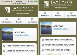
Real-time weather and water quality data are now as close as one’s mobile device. The data originate from NOAA’s National Estuarine Research Reserves, a federal-state partnership that protects 28 designated reserve sites and provides natural areas for scientific research. The SWMP Mobile app provides useful data through any smartphone or tablet. Users can locate monitoring stations, view station locations on Google maps, view near real-time data, and create quick charts. The app also complements the reserves’ other data access resources. The National Estuarine Research Reserve System Centralized Data Management Office, which developed the app, is supported through a cooperative agreement between NOAA's Office for Coastal Management and the University of South Carolina.
 An official website of the United States government.
Here's how you know we're official.


