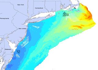
NOAA’s National Centers for Coastal Ocean Science (NCCOS) works closely with the U.S. Department of the Interior, including the Bureau of Ocean Energy Management (BOEM), the U.S. Geological Survey, and the U.S. Fish & Wildlife Service, to deploy mapping tools that support environmental assessment and planning for ocean energy development. Accurate maps and predictions of living marine resource distributions foster effective coastal and marine spatial planning, which reduces potential conflicts between human uses and sensitive marine ecosystems—thereby supporting healthy and resilient coastal communities and economies.
In FY14, NCCOS developed advanced statistical models of seabird and deep-sea coral distributions for the Atlantic Coast and the Gulf of Mexico. By merging large databases of seabird and coral observations with environmental data gleaned from NOAA satellites and ocean observations, NCCOS produced predictive maps of bird and coral distributions and disseminated them through a joint NOAA–BOEM Web service.
Also in FY14, a renewable energy transmission company used NCCOS’s coral distribution maps to help evaluate routing alternatives for a proposed undersea energy transmission cable into Maalaea Bay, Maui. The cable system under consideration would transmit renewable wind power generated in Maui County for consumption on Oahu, contributing to Hawaii’s 2030 goal of having 40 percent of its electricity sales come from renewable energy.

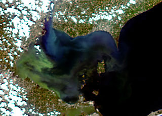
In August 2014, NOAA’s National Centers for Coastal Ocean Science (NCCOS) supported the response to a bloom of cyanobacteria, a toxic blue-green algae, that contaminated drinking water in Lake Erie. The bloom left nearly 400,000 people in Toledo, Ohio, without drinking water for two days.
NOAA’s weekly Lake Erie Harmful Algal Bloom Bulletin, produced by NCCOS and NOAA’s Great Lakes Environmental Research Laboratory, tracks the size and location of blooms and predicts their movement until the bloom season ends in the fall. This year, in response to requests from Ohio agencies, NOAA increased the frequency of the bulletins from once to twice a week. The August 1 bulletin caught escalation of the bloom and helped Toledo prepare for the hazard. NOAA currently provides, or is developing, harmful algal bloom and hypoxia (low dissolved oxygen) forecasts for Lake Erie, the Gulf of Maine, the Chesapeake Bay, the Gulf of Mexico, and the Pacific Northwest.
Also in FY14, NCCOS addressed paralytic shellfish poisoning (PSP)—a public health threat that affects Alaska’s residents more frequently than those residing anywhere else in the U.S. The remoteness of coastal communities in Alaska makes monitoring this threat challenging. NCCOS worked with the Food and Drug Administration and the biotechnology company Mercury Science to develop rapid laboratory and field test kits capable of detecting saxitoxins found in shellfish. Saxitoxins are produced by the microalgae Alexandrium and are the cause of PSP. Shellfish accumulate saxitoxins as they feed on Alexandrium. The saxitoxin field test can be used with minimal training, requires no expensive equipment, and is commercially available.

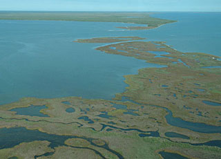
In FY14, scientists funded by NOAA’s National Centers for Coastal Ocean Science found that projected changes in coastal Gulf of Mexico land use and land cover (e.g., urban development) could increase the extent of storm surge flooding by up to 70 percent above the flooding that might be expected from projected sea-level rise alone.
The finding comes from a modeling study that investigated the ecological effects of sea-level rise in the Gulf of Mexico. The study is yielding predictive tools that assist coastal zone managers as they develop strategies to mitigate the future ecological and socioeconomic impacts of climate change.
The study is also the focal point of the Northern Gulf of Mexico Sentinel Site Cooperative, a federal-state partnership established to advance prediction and assessment capabilities for sea-level rise. The cooperative seeks to improve coastal data and research products to foster planning and adaptation to sea-level rise and inundation.

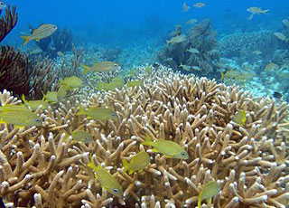
NOAA’s National Centers for Coastal Ocean Science (NCCOS) works with federal, state, and local management agencies to monitor and assess the condition of U.S. coral reef ecosystems within sanctuaries, reserves, and other special places. These productive ecosystems enhance biological diversity, fisheries, tourism, and cultural heritage, and protect shorelines from storm damage.
NCCOS and NOAA’s Southeast Fisheries Science Center (SEFSC) co-lead major components of NOAA’s National Coral Reef Monitoring Plan (NCRMP) – a framework for conducting sustained observations of biological, climate, and socioeconomic indicators at 10 priority coral reefs across the U.S. and its territories. In FY14, NCCOS and SEFSC conducted the first NCRMP fish and invertebrate monitoring missions, in the U.S. Virgin Islands and the Flower Garden Banks National Marine Sanctuary. Officials will use data from the missions to update management plans and ensure continued protection of coral resources at these locations. Also in FY 14, NCCOS conducted a biological assessment of the Florida coral reef tract and paired it with human-use information to develop management recommendations for the Florida Keys National Marine Sanctuary.
NCCOS is also studying the social and economic conditions of communities that depend on coral reefs in seven U.S. states and territories. In FY14, NCCOS scientists surveyed a random representative sample of the adult populations in American Samoa and South Florida. The survey data are being shared with local resource managers and other interested partners who will be able to use the information to improve a range of coral conservation efforts, including education and outreach initiatives and program evaluation.

Marine aquaculture has emerged as one of the fastest-growing activities in the coastal zone. Even as resource managers strive to end overfishing, the future seafood supply will rely on cultured seafood to meet growing demands. More than half of global seafood production already comes from aquaculture. While technological innovation has made it possible to grow seafood in the coastal ocean, managers must weigh economic benefits against environmental risks.
In FY14, NOAA’s National Centers for Coastal Ocean Science (NCCOS) published the report Marine Cage Culture and the Environment: Twenty-First Century Science Informing a Sustainable Industry, which analyzes environmental concerns related to marine cage culture practices around the world. This planning tool provides coastal managers and fish farmers with a global perspective on the range and intensity of potential environmental effects from cage aquaculture.
While not all practices were found to be sustainable, the research concludes that significant advancements of the past decade are addressing environmental concerns about marine fish farms. With proper coastal planning tools and environmental oversight, sustainable growth of aquaculture in the coastal ocean can occur – promoting higher seafood production, supporting the growth of coastal economies, providing healthier American diets, and increasing food security in the United States.
 An official website of the United States government.
Here's how you know we're official.


