U.S. flag An official website of the United States government.

dot gov icon Official websites use .gov

A .gov website belongs to an official government organization in the United States.

https icon Secure websites use HTTPS

A small lock or https:// means you’ve safely connected to a .gov website. Share sensitive information only on official, secure websites.

Gravity

Global Positioning Tutorial

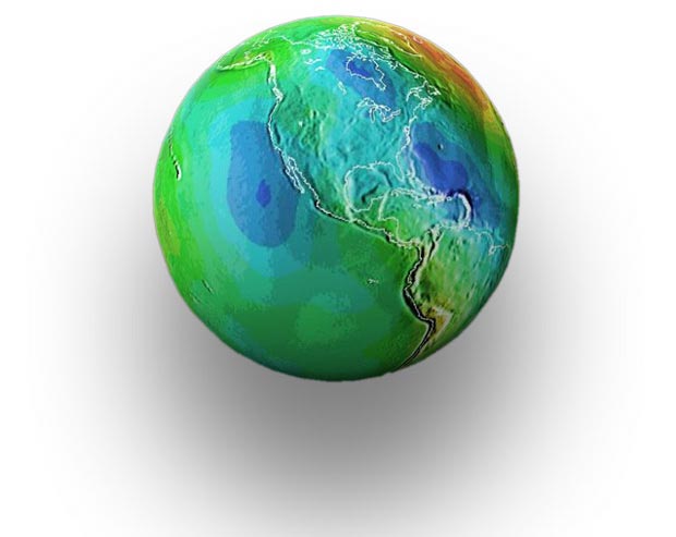
Geoid Earth with inset of North Americ

Imagine if all of the Earth topography, mountains and valleys were scoured off leaving a continuous world's ocean completely at rest, without the effects of currents, weather and tides. The effect of the Earth's gravity on this hypothetical world mean sea level is represented by the geoid. However, because the Earth's gravity is not equal in all places, this hypothetical ocean is not perfectly smooth. The strength of the Earths' gravity, and consequent effect on the shape of the geoid is represented by color variations in this image.

Gravity is the force that pulls all objects in the universe toward each other. On Earth, gravity pulls all objects "downward" toward the center of the planet. According to Sir Isaac Newton's Universal Law of Gravitation, the gravitational attraction between two bodies is stronger when the masses of the objects are greater and closer together. This rule applies to the Earth's gravitational field as well. Because the Earth rotates and its mass and density vary at different locations on the planet, gravity also varies.

Geoid Earth with inset of Indian Ocean

In this global map of the geoid (Geoid99), the area in blue near India indicates a region where the Earth's gravity is weaker. In this area, the mean sea level is lower because the hypothetical ocean has been pulled away from the area of lower gravitational force towards other areas of the globe where the gravitational forces are stronger.

One reason that geodesists measure variations in the Earth's gravity is because gravity plays a major role in determining mean sea level. Geodesists calculate the elevation of locations on the Earth's surface based on the mean sea level. So knowing how gravity changes sea level helps geodesists make more accurate measurements. In general, in areas of the planet where gravitational forces are stronger, the mean sea level will be higher. In areas where the Earth's gravitational forces are weaker, the mean sea level will be lower.

To measure the Earth's gravity field, geodesists use instruments in space and on land. In space, satellites gather data on gravitational changes as they pass over points on the Earth's surface. On land, devices called gravimeters measure the Earth's gravitational pull on a suspended mass. With this data, geodesists can create detailed maps of gravitational fields and adjust elevations on existing maps. Gravity measurements accurately reflect elevation changes on the Earth's surface.

More Information
Roadmap to Resources Subject Review Is the Earth round? (Ocean Facts)
a drawing of a city with text that says location science improves everyday life

Geodesy Education

Heard of geodesy? These videos from NOAA's National Geodetic Survey offer a deep dive into the science of knowing where you – and everything else is in the world!

NSTA - National Science Teachers Association

The National Science Teaching Association (NSTA) includes this resource in its database. NSTA provides educators and students access to Web-based, educationally appropriate science content that has been formally evaluated by master teachers.

Search Our facts
Get Social
Last updated:
02/26/21

Author: NOAA

How to cite this article

Contact Us