The National Geodetic Survey has been measuring land to determine points on the ground and the angles, distances, and heights between them since the 1800s. To do this accurately, you have to understand the force of gravity. Podcast host Megan Forbes talks with Dr. Derek van Westrum, a NGS geodesist and physicist, about what gravity is, why and how it changes, and what it means for NOAA.
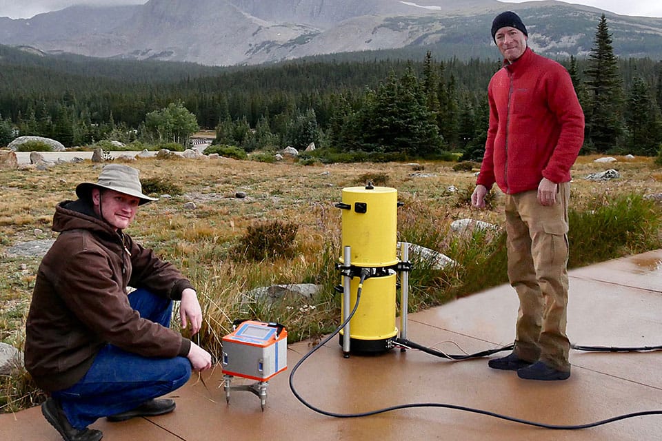
Jeff Kanney (left) and Derek van Westrum prepare to calibrate gravity meters in the high altitudes west of Boulder. Gravity and height are critical to mapping where water will flow.
Transcript
HOST: You’re listening to the NOAA Ocean Podcast, I’m Megan Forbes. We’re going to sit down and talk about... gravity. Gravity is an amazing force that affects our daily lives, but often, it’s really hard to describe. So that’s why I’m sitting down with someone who knows ALL about gravity, and can tell us more about it, Dr. Derek van Westrum. He’s out in Boulder, Colorado, and he’s going to talk with us today about: what gravity really is, why and how it changes on our planet, how we can measure it, and why NOAA is interested in gravity - what we do, how we use it, and what it has to do with the ocean. So, let me give you a fine welcome, Derek, thanks for joining me today. Let’s get right into talking about “what in the world is gravity?”.
DEREK VAN WESTRUM:(laughs) It’s a loaded question. So one of the answers is, nobody really knows why there is gravity. The historical stuff, you can look this up on your favorite webpage; the ancient Greeks thought about this a lot, the ancient Indians thought about this a lot, and I think everybody agrees with Galileo trying to understand its properties by rolling balls down inclined planes...and whether or not he actually dropped something off the top of the Tower of Pisa nobody’s quite sure...but the idea was a heavy object and a light object actually fall at the same rate! That was mysterious and kind of counter-intuitive. The first real modern mathematical concept of gravity came along with [Isaac] Newton, and he described gravity simply as the force of attraction between any masses, proportional to the masses and inversely proportional to the distance between them, squared. That formula was really powerful and it explained apples falling out of trees, it explained planets going around the sun, that kind of stuff. And for 200 years or so, that was the final word on gravity until [Albert] Einstein came along. Einstein came along and radically changed everything! [He said] Masses behave like they do because they actually warped the space-time continuum around them. Things appear to fall at the same time because they are moving in the space-time continuum. That’s the modern concept of gravity. Yeah it’s, surprisingly, for such a common everyday thing that we experience, it is really a hard thing to fundamentally understand.
HOST: And you know a lot about gravity because you are a physicist, is that right?
DEREK VAN WESTRUM: That is correct, yep. My background is physics.
HOST: For NOAA, you apply your physics in a specific way. How is that, again?
DEREK VAN WESTRUM: Right, it’s a big question - why is somebody in NOAA, especially the Ocean Service, interested in measuring gravity? My background is really making instruments that measure gravity, and for years I did that at a small company, and now I use those instruments, or similar instruments to measure gravity.
HOST: So we’re measuring it...does that mean gravity changes at different points on the earth or in time? Isn’t gravity the same all the time?
DEREK VAN WESTRUM: Great question. So to a certain approximation, gravity is pretty much the same everywhere. In a high school physics course you may learn it’s about 9.8 ㎧ per second is acceleration of an object when you drop it. I guess in the old days it was 32 ft/s per second...but it turns out, that number changes a little bit as you move around the surface of the earth. So, the earth itself isn’t really a sphere, it’s more of a “squished sphere” called an ellipsoid. The earth is wider at the equator than it is from pole to pole, because it is spinning and kind of bulges out due to its own acceleration. So at the pole, you’re actually closer to the center of the earth than you are at the equator, and Newton’s law would tell you that if you are closer to the center of the earth, gravity will be stronger there. Sure enough, it’s something like a half percent effect. Gravity gets a half percent stronger if you go from the equator to the poles. But - if you measure more accurately, you can start to do things like, if you go up a mountain you can see that gravity is getting weaker as you move farther from the center of the earth. So yeah, gravity changes everywhere you go. A modern gravity meter is so sensitive you can actually see something like a quarter inch or a few millimeters [difference]. If you lift the gravity meter up, it will read weaker gravity - that’s how sensitive these things are now.
HOST: What’s the point of measuring how gravity changes? How does it affect our daily lives when the gravity changes to that 9th digit?
DEREK VAN WESTRUM: None of these changes in gravity are something you can actually feel in your day-to-day, everything pretty much feels like 9.8 m/s2. If you throw a baseball - even if you’re at the North Pole - it’s going to pretty much go where you expect it to. But you can ask what are applications, if you do know gravity changes in these small, subtle ways, what can you do with that information. For example, USGS (United States Geological Survey), they study hydrology by knowing where voids are under the ground, and seeing a change in gravity over time, they can say “oh, there’s water filling that void, or it’s a recharge cycle”. So hydrology is an application that gets used a lot. Of course, there’s oil and gas exploration using similar [ways] - if you drive a gravity meter down the road and it’s less dense, you have less gravity below you, that may be an indication of water or oil instead of rock being below you.
HOST: So that’s really interesting to note that gravity depending on where you are located on the earth, or the different height or depth that you’re at, or where you are on the actual surface of the earth - that’s very interesting to me. What does that mean for NOAA? What does that mean for the ocean?
DEREK VAN WESTRUM: So yeah, so what we’re doing with gravity is make a new modern height system. In the old days, what folks would do if you wanted to know the height of a mountain is you’d walk down to the ocean and back with some rulers and keep track of the heights the whole way! We’re actually defining...well, it’s a little bit of a complicated concept...so there’s the value of gravity, and there’s a thing called “gravity potential” which is the energy something gets if you lift if up in a gravity field. So it turns out, if you can define the strength of the gravity potential at the ocean, at sea level, if you have a gravity map of the entire continent, you can predict where that same level will be under the land. In other words, in Colorado here, we can say “hey, we know the gravity below us, and we know the kind of rock around us, we can predict where sea level would be directly under us and then we can use that to be the new zero for height systems”. You don’t need to go to the ocean and back. And it turns out, we can do that estimation very accurately, to something like an inch or better.
So the reason it is helpful for everybody is, if you have a map like that, that surface where sea level is underneath the land is actually kind of lumpy and rolls around. That’s because it’s taking into account the local gravity - more dense rock may be in Colorado than, say, in Utah. So it really becomes important in low-lying flat places where the land may look flat, but if the rock is more dense somewhere water will flow where you may not expect it to. That’s the real thing that we’re trying to do. This new height system will inherently have knowledge of where water will flow. A new height map of Southern Texas, which is prone to flooding, will now be much more accurate in terms of water flow.
HOST: So this is something that could be helpful in planning for changes in seal level or coastal flooding or inundation?
DEREK VAN WESTRUM: Yeah...flooding is probably the number one most obvious thing that you can point to. This will be really useful for a lot of people. Basically anything that involves water, for example in Colorado, if you want to make a ditch somewhere, instead of getting rulers and surveying huge areas, you can basically just set up antennas and use our correction of where sea level is below you to know your height difference, and it will predict automatically which way water will flow. So it’s really supporting all sorts of infrastructure projects, anything that really requires precise positioning will be helped by this.
So what we’re doing now...as I mentioned we need to know gravity over the entire continent...and in fact, not only are we doing the lower 48, but all of the United States territories. The way we do that is we put gravity meters into airplanes, and literally it is like mowing the lawn - we fly back and forth on a 10 kilometer grid, and get a measure of the surface gravity over the United States. We are about 81% done, we expect to finish flying in about the next two years and then it will probably take one more year to compile all that data, analyze it and combine it into a model that will explain where that sea level is under the land. In 2023 we expect to start unveiling it. That said, we have been slowly unveiling sneak peeks for everybody that’s interested, for the last six years now. If your area has been flown, you will see what the new sea level will look like under your area on our website: ngs.noaa.gov. And that project is called GRAV-D, Gravity for the Redefinition of the American Vertical Datum.
HOST: So once the system is in place, what will people notice - is there going to be a difference? How would someone like me access this new system, or know that it’s in place?
DEREK VAN WESTRUM: Ah, very good question! So there’s actually a couple of ways a “normal person” would notice this. First and foremost, the official, the surveyor or the professional, the way its gonna work for them, they will do a survey with a GPS antenna, and in a few hours will get extremely precise positioning, something like a centimeter or two. We’ll then work with the manufacturers - we’ll have the correction for the new sea level - if you want to call it that - it will be in their hardware. So they’ll know immediately what their height above sea level is, and which way water will flow towards another part of a project. For the general public, it really depends on where you live. In Colorado, we’ve got a collection of “14’ers”, these peaks that are above 14,000 feet at the summit, and it turns out, everything in Colorado on average is probably going to drop by about two feet. So people in Colorado will notice that the elevation signs in the towns will go down by two feet, and there’s a question of whether or not one of these “14’ers” will drop down below the 14,000 mark...we’ll have to wait a couple of years to find out! In everyday usage you probably won’t notice it that much, but there are a few people who will definitely notice it, like I said, professionals and surveyors, especially.
HOST: Well that’s about all the time we have for today...this is a very complicated subject, I’ve certainly learned, in talking to you...but you’ve given me a little more understanding at least on how it’s used in everyday and why NOAA is interested in gravity and what you’re specifically doing to help us learn more. So, thank you very much! I really appreciate it.
DEREK VAN WESTRUM: Well great, thanks so much for having me!
HOST: Again thanks to Dr. Derek van Westrum from the National Geodetic Survey in Boulder, Colorado, for talking to me today about gravity. If you’d like to learn more about this subject, or any ocean-related subject, check out our website at oceanservice.noaa.gov. Thanks for taking the time to listen with us, and we’ll see you next time.
 An official website of the United States government.
Social