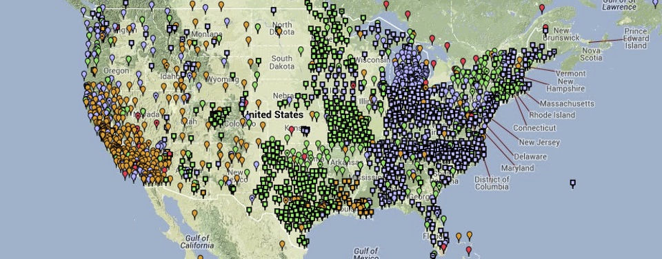
NOAA's National Geodetic Survey defines and manages the National Spatial Reference System (NSRS) - a consistent coordinate system that defines latitude, longitude, height, scale, gravity, and orientation throughout the United States. In addition to a network of continuously operating reference stations (CORS) supporting three-dimensional positioning activities (shown here), the NSRS includes a network of permanently marked points; a consistent, accurate, and up-to-date national shoreline; and a set of accurate models describing dynamic, geophysical processes that affect spatial measurements.
All of the elements of geodesy are joined together in the National Spatial Reference System (NSRS). For almost 200 years, the National Geodetic Survey (NGS) and its predecessors have been using geodesy to map the U.S. shoreline, determine land boundaries, and improve transportation and navigation safety. NGS evolved from the Survey of the Coast, an agency established by Thomas Jefferson in 1807. The creation of the United States' first civilian scientific agency was prompted by the increasing importance of waterborne commerce to the fledgling country. As the nation grew westward, NGS's mission began to include surveys of the North American interior.
With numerous surveys being conducted simultaneously across the growing nation, the surveyors needed to establish a common set of reference points. This would insure that surveyors' maps and charts, which often covered hundreds of miles, would align with each other and not overlap. The common set of reference points they used were the bench marks from the horizontal and vertical datums. Today, the complete set of vertical and horizontal bench marks for the United States is known as the NSRS. This defined group of reference points acts as the foundation for innumerable activities requiring accurate geodetic information.
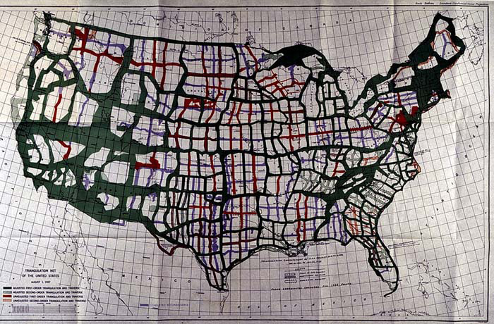
A United States triangulation network map from 1937. Developing a network of areas based on manual surveys using triangulation was a precursor to today's modern National Spatial Reference System, which is overseen and continuously monitored by the Global Positioning System.
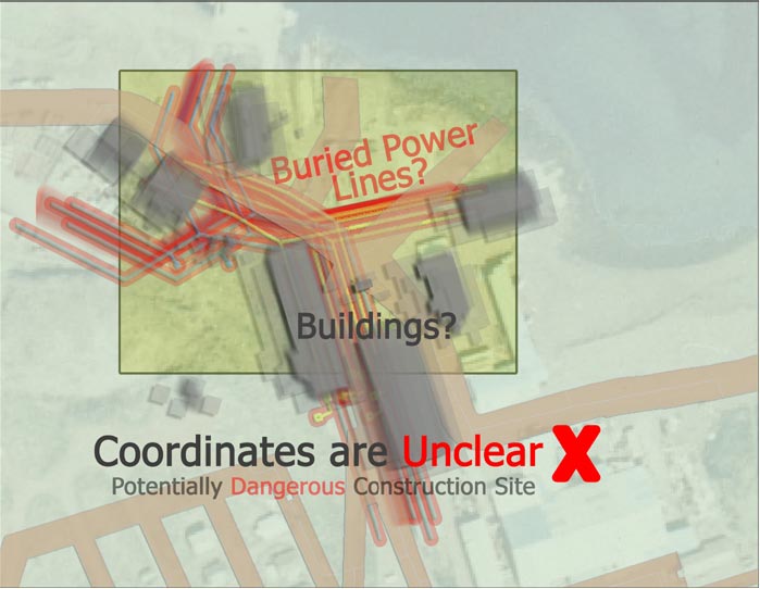
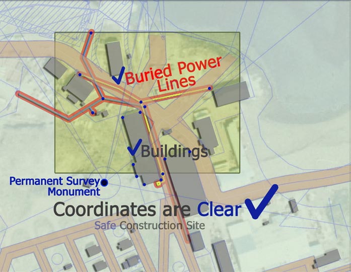
Think of it this way: When construction workers begin to build, they have to be sure that the area where they are building is free from dangerous power lines. The construction team will have to find out where the power lines are and make sure they are not building on top of them. To ensure success, the team needs to know the coordinates of the building site and of the local power lines. The NSRS provides a framework for identifying these coordinates. The team can then compare the two sets of coordinates and make sure they do not overlap.
To identify NSRS bench marks, NGS has traditionally placed permanent markers where coordinates have been determined. These markers are brass or bronze disks (metals that sustain weathering) and are set in concrete or bedrock. Each marker is about 9 centimeters wide and has information about NGS printed on its surface.
Today, NGS uses a different kinds of marker made from long steel rods, driven to refusal (pushed into the ground until they won't go any farther.) The top of each rod is then covered with a metal plate. This method ensures that the mark won't move and that people can't destroy or remove it. After tying these marks into a specific horizontal or vertical datum, the mark can be included in the NSRS database. Once the coordinates of the mark are entered into this database, they are available for anyone to use.
The National Spatial Reference System (NSRS) is a set of permanent markers that act as the foundation for many activities requiring accurate spatial information. For example, when construction workers are working near a building, they need to know where the building lies in relation to power lines. Without the NSRS, the location of the buildings and the power line are unclear. By comparing the coordinates for the location of the building and the power lines, the construction team will have a clear picture of where things lie and can avoid potentially dangerous situations.
Heard of geodesy? These videos from NOAA's National Geodetic Survey offer a deep dive into the science of knowing where you – and everything else is in the world!
The National Science Teaching Association (NSTA) includes this resource in its database. NSTA provides educators and students access to Web-based, educationally appropriate science content that has been formally evaluated by master teachers.
 An official website of the United States government.

Social