The vertical datum is a collection of specific points on the Earth with known heights either above or below mean sea level. Near coastal areas, mean sea level is determined with a tide gauge. In areas far away from the shore, mean sea level is determined by the shape of the geoid.
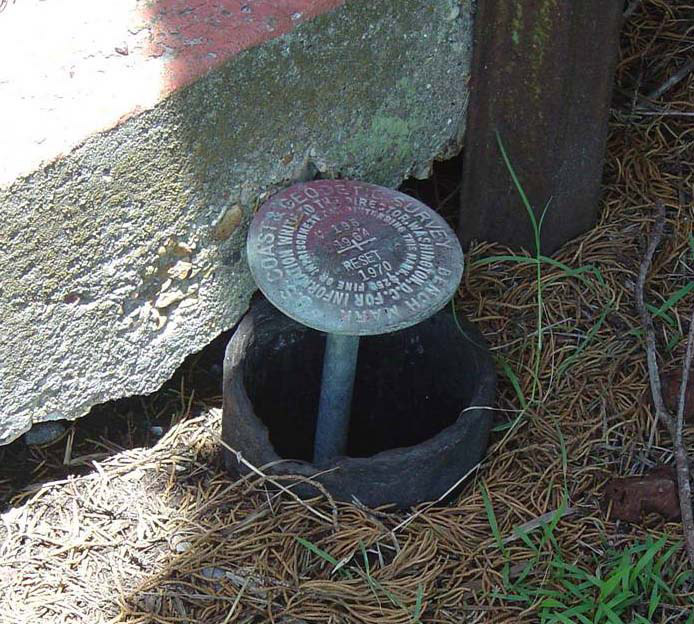
Similar to the survey markers used to identify known positions in the horizontal datum, many positions in the vertical datum are marked by steel rods driven into the ground with a hinged access cover. Using a technique called differential leveling, a known elevation at one location is used to determine the elevation at another location. As with horizontal datums, the advanced technology of GPS has almost completely replaced this classical technique of vertical measurement.
In 1929, the National Geodetic Survey (NGS) compiled all of the existing vertical bench marks and created the National Geodetic Vertical Datum of 1929 (NGVD 29). Since then, movements of the Earth's crust have changed the elevations of many bench marks. In 1988, NGVD 29 was mathematically adjusted to remove inaccuracies and to correct distortions. This datum, called the North American Vertical Datum of 1988 (NAVD 88), is the most commonly used vertical datum in the United States today.
In 2022, scientists at the National Geodetic Survey are scheduled to complete 15-year-long project to update the vertical datum, which will make accurate height measurement better, faster, and cheaper. This project is called the Gravity for the Redefinition of the American Vertical Datum, or GRAV-D for short. When this effort is completed, users will be able to get accurate heights to within about an inch for most locations around the nation.
The position of this vertical survey marker in Louisiana has been upset due to significant subsidence (sinking) of the surrounding area. Similar to the survey markers used to identify positions in the horizontal datum, round brass plates mark positions in the vertical datum. The markers are embedded in concrete or bedrock to maintain their positions and, therefore, the integrity of the geodetic control point.
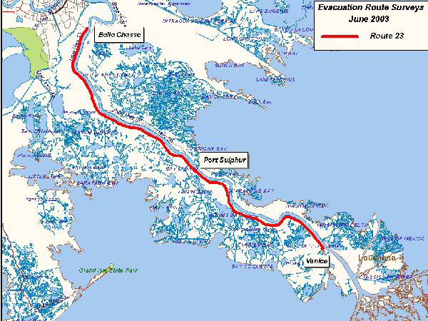
One of the main uses of the vertical datum is to measure rates of subsidence, or land sinking. In Louisiana, for example, large areas of land are rapidly sinking. This is the result of development, coastal erosion, and groundwater withdrawals. In many areas, the only way to escape an incoming hurricane is to follow specific hurricane evacuation routes. If state and local officials do not have accurate elevation information about these routes, residents trying to leave during an emergency might get trapped in fast-rising water.
By referencing the vertical datum, officials can determine the true elevation and position of the hurricane evacuation routes, as well as how much they have sunk over past decades. For example, in Plaquemines Parish, Louisiana, the main hurricane evacuation route, Highway 23, and the surrounding levees are subsiding by one-quarter to one-half inch per year.
Highway 23 is the main hurricane evacuation route for the entire state of Louisiana. Vertical bench marks have been critical in tracking the rate of subsidence in the area and allowing officials to develop up to date emergency evacuation plans.
Heard of geodesy? These videos from NOAA's National Geodetic Survey offer a deep dive into the science of knowing where you – and everything else is in the world!
The National Science Teaching Association (NSTA) includes this resource in its database. NSTA provides educators and students access to Web-based, educationally appropriate science content that has been formally evaluated by master teachers.
 An official website of the United States government.

Social