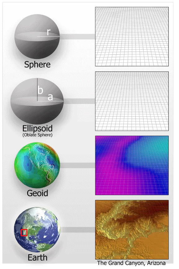
Because the surface of the Earth is irregular and complex, geodesists use simplified mathematical models of the Earth for many applications. The simplest model of the Earth is a sphere. A much more complex model of the Earth is the geoid, used to approximate mean sea level. Even the geoid is a simplified model, however, when compared to actual topographic relief, as shown in this image of four figures of the Earth (Grand Canyon).
The Earth's shape is nearly spherical, with a radius of about 3,963 miles (6,378 km), and its surface is very irregular. Mountains and valleys make actually measuring this surface impossible because an infinite amount of data would be needed. For example, if you wanted to find the actual surface area of the Grand Canyon, you would have to cover every inch of land. It would take you many lifetimes to measure every crevice, valley, and rise. You could never complete the project because it would take too long.
To measure the Earth and avoid the problems that places like the Grand Canyon present, geodesists use a theoretical mathematical surface called the ellipsoid. Because the ellipsoid exists only in theory and not in real life, it can be completely smooth and does not take any irregularities — such as mountains or valleys — into account. The ellipsoid is created by rotating an ellipse around its shorter axis. This matches the real Earth's shape, because the earth is slightly flattened at the poles and bulges at the equator.
While the ellipsoid gives a common reference to geodesists, it is still only a mathematical concept. Geodesists often need to account for the reality of the Earth's surface. To meet this need, the geoid, a shape that refers to global mean sea level, was created. If the geoid really existed, the surface of the Earth would be equal to a level in between the high-tide and low-tide marks.
Although a geoid may seem to be a smooth, regular shape, it isn't. The Earth's mass is unevenly distributed, meaning that certain areas of the planet experience more gravitational "pull" than others. Because of these variations in gravitational force, the "height" of different parts of the geoid is always changing, moving up and down in response to gravity. The geoidal surface is an irregular shape with a wavy appearance; there are rises in some areas and dips in others.
Heard of geodesy? These videos from NOAA's National Geodetic Survey offer a deep dive into the science of knowing where you – and everything else is in the world!
The National Science Teaching Association (NSTA) includes this resource in its database. NSTA provides educators and students access to Web-based, educationally appropriate science content that has been formally evaluated by master teachers.
 An official website of the United States government.
Social