Using the Global Positioning System (GPS), every point on Earth can be given its own unique address—its latitude, longitude, and height. The U.S. Department of Defense developed GPS satellites as a strategic system in 1978. But now, anyone can gather data from them. For instance, many new cars have a GPS receiver built into them. These receivers help drivers know exactly where they are, and can help them from getting lost.
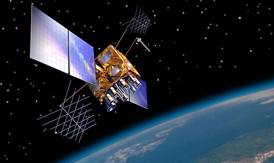
GPS is a constellation of satellites that orbit approximately 11,000 miles above the Earth and transmit radio wave signals to receivers across the planet. By determining the time that it takes for a GPS satellite signal to reach your receiver, you can calculate your distance to the satellite and figure out your exact location on the Earth. Sound easy? In fact it is a very complicated process. For the GPS system to work, you need to have incredibly precise clocks on the satellites and receivers, and you must be able to access and interpret the signals from several orbiting satellites simultaneously. Fortunately, the receivers take care of all the calculations.
Let's tackle the distance calculation first. GPS satellites have very precise clocks that tell time to within 40 nanoseconds or 40 billionths (0.000000040) of a second. There are also clocks in the GPS receivers. Radio wave signals from the satellites travel at 186,000 miles per second. To find the distance from a satellite to a receiver, use the following equation: (186,000 mi/sec) x (signal travel time in seconds) = Distance of the satellite to the receiver in miles.
The Global Positioning System (GPS) is a constellation of satellites orbiting the Earth approximately 11,000 miles in space. The GPS satellites in this animation are not drawn to scale. However, their orbits and orientation to the Earth are approximately correct. GPS satellites are organized into six different orbital paths completely covering the Earth. Looking at the Earth top down from the North Pole, the six orbits are spaced at 60 degree intervals. Looking at the Earth from the equator, each orbit is moderately tilted at 50 degrees.
Think of it this way: When construction workers begin to build, they have to be sure that the area where they are building is free from dangerous power lines. The construction team will have to find out where the power lines are and make sure they are not building on top of them. To ensure success, the team needs to know the coordinates of the building site and of the local power lines. The National Spatial Reference System (NSRS) provides a framework for identifying these coordinates. The team can then compare the two sets of coordinates and make sure they do not overlap.
The NSRS includes traditionally placed markers, or permanent monuments, where the coordinates have been determined. Many of these markers are brass or bronze disks (metals that sustain weathering) and are set in concrete or bedrock. Most markers are about 9 centimeters wide and have information about NGS printed on their surfaces. Others are made from long steel rods, driven to refusal (pushed into the ground until they won't go any farther.). The top of each rod is then covered with a metal plate. This method ensures that the mark won't move and that people can't destroy or remove it.
With the advent of the Global Positioning System (GPS), positioning these markers became much faster and easier than traditional methods. Positioning these marks ties them to a specific horizontal or vertical datum, and then the mark helps define the NSRS. The positioning data about the marks is collected by surveyors with very accurate GPS receivers and is then loaded into the NGS database. Once the coordinates of the mark are entered into this database, they are available for anyone to use, and makes the NSRS available to everyone.
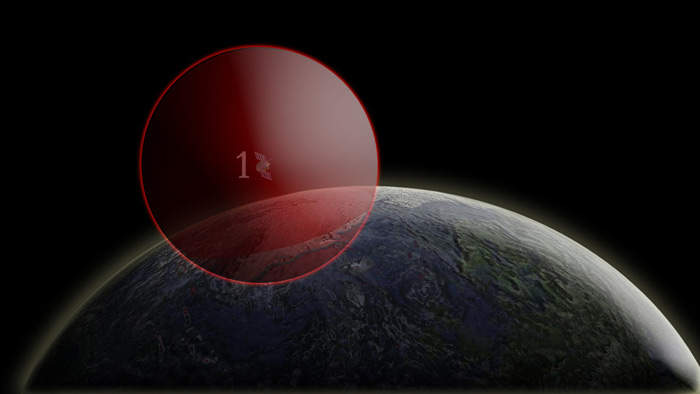
GPS satellites and positioning: one satellite
It takes four GPS satellites to calculate a precise location on the Earth using the Global Positioning System: three to determine a position on the Earth, and one to adjust for the error in the receiver's clock. If you were 15,000 miles from only one satellite (satellite with red sphere), you could be anywhere on an imaginary red sphere that has a radius equal to the number of miles from the satellite (15,000 miles).
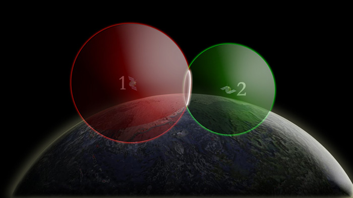
GPS satellites and positioning: two satellites
When you add a second satellite (satellite with green sphere), about 12,000 miles away, you can only be where these two imaginary spheres intersect (the white circle).
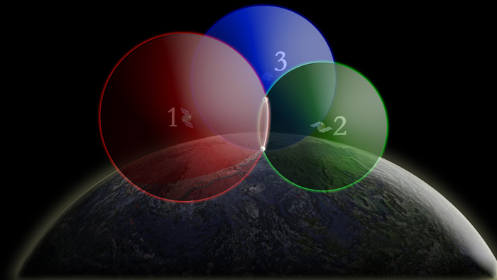
GPS satellites and positioning: three satellites
When you add a third satellite (satellite with a blue sphere) you can come close to finding your exact position on the Earth. Imagine that you are 14,000 miles from the third satellite. In this situation, there are only two points (the two white points) where you could possibly be. These points are where the 14,000-mile sphere intersects with the 15,000-mile and 12,000-mile spheres.
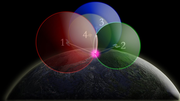
GPS satellites and positioning: four satellites
To correct for the GPS receiver's clock error and find your precise position, a fourth satellite (satellite with the yellow sphere) must be used. With the fourth satellite, small timing errors from all four satellites to the point on the Earth have been adjusted, and your exact location on the Earth (the purple point) can be determined.
Heard of geodesy? These videos from NOAA's National Geodetic Survey offer a deep dive into the science of knowing where you – and everything else is in the world!
The National Science Teaching Association (NSTA) includes this resource in its database. NSTA provides educators and students access to Web-based, educationally appropriate science content that has been formally evaluated by master teachers.
 An official website of the United States government.

Social