The Office of Coast Survey (OCS) provides navigation products and services that ensure safe and efficient maritime commerce on America’s ocean and coastal waters and in the Great Lakes.
NOAA Upgrades Global Surge and Tide Forecast System
SUPPORTS NOS PRIORITY: PREPAREDNESS AND RISK REDUCTION
In July 2021, the Global Extratropical Surge and Tide Operational Forecast System (Global
ESTOFS) upgrade to version two was implemented into operations on the National Weather
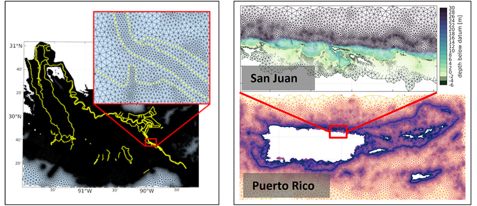
Service’s (NWS) Weather and Climate Operational Supercomputing System. Global ESTOFS provides model forecast guidance of the combined water level caused by storm surge and tides globally, and is the highest resolution global operational storm surge modeling system available today. The forecast guidance from the model is used by the marine navigation and disaster mitigation communities, including forecasters at NWS offices and NOAA’s Ocean Prediction Center, to generate storm surge and flood forecasts during storms, including Nor’easters along the East Coast. Thanks to close collaboration with the University of Notre Dame, version two of the ESTOFS includes many enhancements to improve model performance, resolution, and coverage, including implementation of levees in Louisiana and improved spatial resolution for Puerto Rico. The model has four forecast cycles per day, providing water level forecast guidance out to 7½ days. Users can expect greatly improved water level forecast guidance with this upgrade.
The major upgrade of Global ESTOFS to version two includes the implementation of federal levees in Louisiana and Mississippi (yellow, left), and significant improvement in spatial resolution and inclusion of a floodplain for Puerto Rico (right).
NOAA Transitions Away from Paper, Raster Navigational Charts
SUPPORTS NOS PRIORITY: SAFE AND EFFICIENT TRANSPORTATION AND COMMERCE
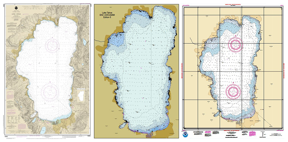
NOAA began to implement its transition plan away from paper nautical charts in February 2021, starting with paper chart 18665, Lake Tahoe. After August 2021, NOAA’s Electronic Navigational Chart (ENC®) was the only NOAA nautical chart of the area. These electronic charts are easier to update and maintain, keeping mariners safer with up-to-date information on marine hazards. A new option for paper nautical charts is available through the NOAA Custom Chart application. The application, released in April 2021, is a dynamic map tool that allows users to create their own paper and PDF nautical charts derived from the official NOAA ENCs. NOAA Custom Chart uses the best available data, delivers an improved service for users, and ensures consistency between ENCs and NOAA Custom Chart PDFs, resulting in an up-to-date chart regardless of the final format.
Chart 18665, Lake Tahoe, is the first traditional paper chart to be fully supplanted by an ENC. Shown left: chart 18665 Lake Tahoe. Center: the NOAA ENC with the same coverage. Shown right: a NOAA Custom Chart derived from the ENC data for Lake Tahoe.
NOAA’s PMN Program Issues First Major Data Update, New Website
SUPPORTS NOS PRIORITY: SAFE AND EFFICIENT TRANSPORTATION AND COMMERCE
NOAA's Precision Marine Navigation (PMN) program released two new visualization resources in January 2021. The program also completed the first update of its prototype navigation data service, adding the PMN Data Gateway and the PMNdata processing and dissemination system in April 2021. The data processing and dissemination system provides surface current forecast guidance from NOAA’s forecast systems in a prototype marine navigation data format. The Data Gateway allows users to visualize predictions and their locations. These services will support users across the maritime industry to help them make safe, efficient decisions regarding navigation. The PMN program also launched a new website in September 2021 that will improve the use and accessibility of NOAA’s marine navigation products and services. The website, Marine Navigation, includes links and short descriptions to NOAA’s various navigation resources, providing a one-stop shop that mariners can visit to get the data that they need.
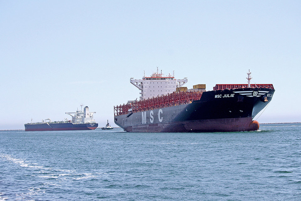
Cargo vessels navigating into the Port of Los Angeles-Long Beach, California.
Progress on Mapping U.S. Waters and Data Archiving
SUPPORTS NOS PRIORITY: SAFE AND EFFICIENT TRANSPORTATION AND COMMERCE
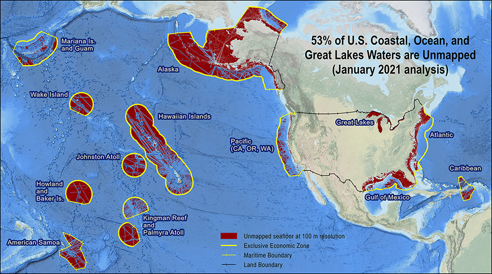
According to the second annual progress report on unmapped U.S. waters, 53% of U.S. waters remain unmapped as of January 2021. Data on the depth, shape, and composition of the seafloor is necessary to explore, sustainably develop, conserve, and manage our coastal and offshore ocean resources. This progress report, compiled by NOS and released by the Interagency Working Group on Ocean and Coastal Mapping, shows that roughly 36,000 square nautical miles of new bathymetric data have been published in NOAA archives since the last analysis. The 2020 National Strategy for Mapping, Exploring, and Characterizing the United States Exclusive Economic Zone (NOMEC) and the global Seabed 2030 initiative make comprehensive ocean mapping a priority for the coming decade. In addition, OCS’s external source data team recently partnered with the Office of Marine and Aviation Operations and National Centers for Environmental Information to archive bathymetric and oceanographic data held by the NOAA fleet. The progress report and fleet data rescue project support important mapping initiatives such as NOMEC, Seabed 2030, and the National Bathymetric Source.
Geographic distribution and extent of the unmapped areas within U.S. ocean, coastal, and Great Lakes waters. Analysis conducted in January 2021.
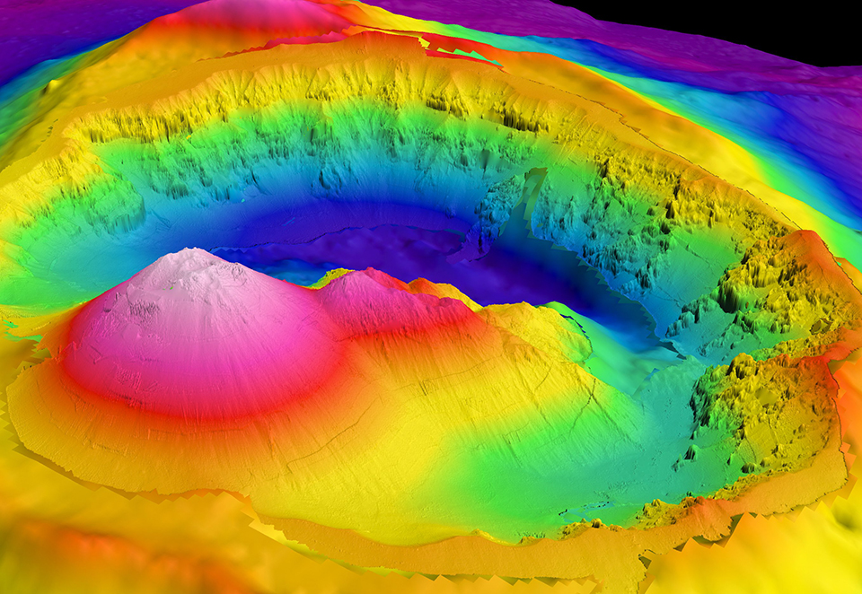
IOC Endorses OCS UN Ocean Decade Contribution
SUPPORTS NOS PRIORITY: SAFE AND EFFICIENT TRANSPORTATION AND COMMERCE
OCS submitted a United Nations Decade of Ocean Science for Sustainable Development contribution on promoting Seabed 2030 and ocean mapping, which was officially endorsed by the Intergovernmental Oceanographic Commission (IOC) in July 2021. This contribution highlights many ongoing OCS efforts, including on NOMEC and the Seabed 2030 project, modeling and forecasting, the S-100 universal hydrographic model, and mapping the Arctic. The contribution calls for a bottom-up approach for collecting data, which encourages better science and decision-making. It also promotes advancing areas that can benefit from new data, while also supporting good ocean governance, resource management, the Blue Economy and other U.N. Decade of Ocean Science programs. Follow-up activities on the contribution have started, including a satellite activity focused on hydrography and mapping for the U.N. Predicted Ocean Laboratory.
Hydrography and mapping are essential to the U.N. Decade of Ocean Science. Hydrographic data helps us visualize and understand the features of the seafloor, as in this high-resolution map of the Brothers submarine volcano north of New Zealand.
 An official website of the United States government.
Social