Hurricane Ida made landfall as Category 4 hurricane in Lafourche Parish near Port Fourchon, Louisiana, with maximum sustained wind speeds of 150 mph (241 kph) and a minimum air pressure of 930 millibars. Landfall occurred at 11:55 a.m. on August 29, 2021. The storm caused catastrophic damage from wind and storm surge, particularly in lower Terrebonne and Lafourche parishes. The damage spread well inland, across southeast Louisiana and southern Mississippi as the storm remained at hurricane strength into southwest Mississippi near McComb.
Center for Operational Oceanographic Products and Services (CO-OPS)
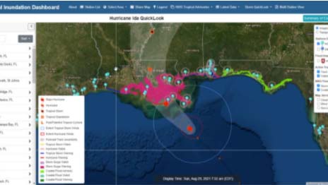
CO-OPS Provides Crucial Water Level Information During Ida
The Coastal Inundation Dashboard shows elevated water levels at locations along the Gulf Coast as Hurricane Ida makes landfall.
During Hurricane Ida, the water level station at Pilots Station East, Louisiana, recorded water levels 1.2 meters (3.9 feet) above Mean Higher High Water (MHHW), the second-highest water level recorded there behind Hurricane Katrina in 2005. As Ida swept north, the water level station at Newbold, Pennsylvania, detected record high water levels at 1.47 meters (4.8 feet) above MHHW, exceeding levels during Hurricane Sandy by almost 0.3 meters (1 foot). Many other water level stations from Louisiana to Florida observed peak water levels 0.6-1.2 meters (2-3.9 feet) above MHHW. The First Street Wharf current meter in New Orleans captured storm surge that briefly caused the Mississippi River to flow in reverse.
National Geodetic Survey (NGS)
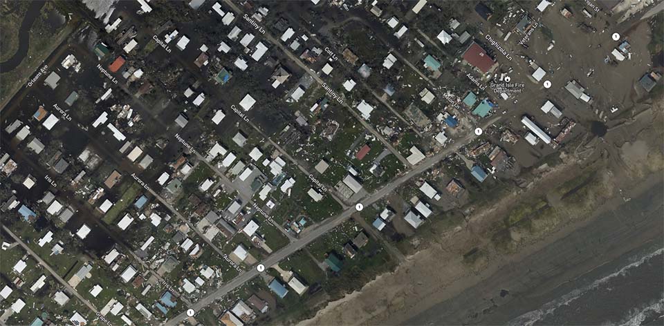
NGS Collects Emergency Response Imagery After Ida
From August 30 to September 2, 2021, NGS collected aerial images in the aftermath of Hurricane Ida. The crew flew over 3,090 square kilometers (1,193 square miles) during 17.1 hours and collected 8,443 images. NOAA collected imagery in specific areas as assigned by the Federal Emergency Management Agency in coordination with the impacted states and other federal agencies. NOAA's aerial imagery aids safe navigation and captures damage to coastal areas caused by a storm. Aerial imagery is a crucial tool used to determine the extent of the damage inflicted by flooding, and to compare baseline coastal areas to assess the damage to major ports and waterways, coastlines, critical infrastructure, and coastal communities. This imagery provides a cost-effective way to better understand the damage sustained to both property and the environment.
Aerial image of Hurricane Ida damage over Grand Isle, Louisiana.
Office of Coast Survey (OCS)
OCS Mobilizes Emergency Response to Hurricane Ida
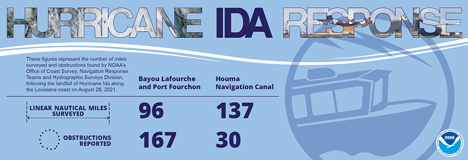
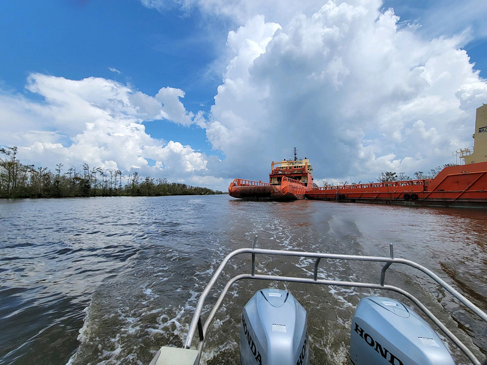
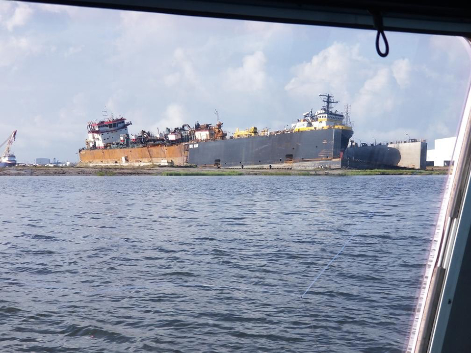
OCS staged teams and moved assets to survey entrance channels and ports in Louisiana n the aftermath of Hurricane Ida. Regional navigation managers fielded survey requests and coordinated with port directors and the Army Corps of Engineers. Navigation response teams mobilized and surveyed areas in Port Fourchon, and the ports of Morgan City and Houma-Terrebonne, Louisiana. OCS’s Hydrographic Services Division executed a contract to survey the deepwater approaches to these ports. Port Fourchon currently services over 90% of the Gulf of Mexico’s deepwater oil production and plays a strategic role in furnishing the U.S. with approximately 18% of its entire oil supply. The port was hit hard by the hurricane; these surveys helped safely reopen the port as quickly as possible.
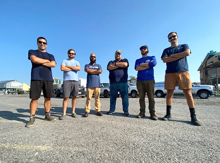
Navigation Response Team-Stennis responds to Hurricane Ida in Louisiana. From left to right: Lt. Cmdr. John Kidd, Josh Hiteshew, Maurice Mitchell, Josh Bergeron, Alex Ligon, and Ensign Collin McMillian.
Following Hurricane Ida in Southeast Louisiana, OCS helped speed up the reopening of vital ports by assisting with channel surveys and multibeam surveys of the ports.
Navigation Response Team-Stennis surveys a section of the Houma Navigation Canal in Louisiana a day after Hurricane Ida made landfall. This image shows last of a long line of ships that broke away from their moorings and drifted down the waterway during the hurricane. The stern of the ship is protruding into the channel.
Office of Response and Restoration (OR&R)
OR&R Provides Support for Pollution, Marine Debris, Damage Assessment
In the wake of Hurricane Ida, OR&R coordinated NOAA’s support for federal and state agencies in the areas of pollution, marine debris, and damage assessment. OR&R’s spatial data experts used the Environmental Response Management Application (ERMA) as a common operating picture to analyze satellite imagery to locate displaced vessels and potential hazardous substance releases. ERMA displayed data from two larger spills, as well as over 2,500 pollution threats. The application saw a nearly 80% increase in use in the wake of Hurricane Ida, with over 200 data layers uploaded, and it was still in use as of this writing to guide cleanup, restoration, and marine debris removal efforts in Louisiana.
OR&R provided support to the Hurricane Ida Debris Task Force to help address the estimated 10.7 million cubic meters (14 million cubic yards) of marine debris caused by Ida. NOAA also provided guidance documents on best practices for marine debris response and removal to local parish and municipal governments.
OR&R also provided incident coordination across the National Ocean Service. In advance of the storm, the NOAA Gulf of Mexico Disaster Response Center opened its doors for operational support to NGS and OCS.
 An official website of the United States government.
Social