U.S. Integrated Ocean Observing System (IOOS®) produces, integrates, and communicates high-quality ocean, coastal, and Great Lakes information that meets the nation's safety, economic, and stewardship needs.
Enhancing Monitoring and Detection of Harmful Algal Blooms
SUPPORTS NOS PRIORITIES: SAFE AND EFFICIENT TRANSPORTATION AND COMMERCE; PREPAREDNESS AND RISK REDUCTION; STEWARDSHIP, RECREATION, AND TOURISM
An aerial view of Lake Okeechobee in Florida shows an algal bloom. A third of all lakes studied by the U.S. Geological Survey contained toxins produced by similar blooms. Credit: Nicholas Aumen, U.S. Geological Survey.
IOOS allocated $2.5 million for seven pilot projects and a harmful algal bloom (HAB) technology testbed across eight of its regional associations in Fiscal Year 2021. The projects aim to enhance the nation’s capacity for monitoring and detection of these blooms. The pilot projects focus on data integration and information services about the extent, toxicity, and length of blooms, and will inform decisions of coastal managers, seafood harvesters and aquaculture growers, drinking water utilities, animal stranding networks, and others. The pilots build on HAB initiatives in all of the IOOS Regional Associations and include development and support for regional HAB bulletins as well as support for HAB forecasts, regional HAB networks, HAB monitoring infrastructure, HAB models, alert systems, and community science efforts.
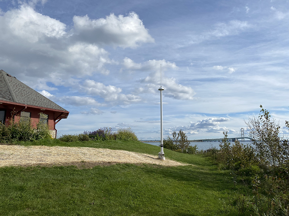
New High-frequency Radar Coming to the Great Lakes
SUPPORTS NOS PRIORITIES: SAFE AND EFFICIENT TRANSPORTATION AND COMMERCE; PREPAREDNESS AND RISK REDUCTION; STEWARDSHIP, RECREATION, AND TOURISM
For the first time, IOOS's surface currents program will bring high frequency radar (HFR) sensors to the Great Lakes in 2022, installing a pair of the sensors at the Straits of Mackinac in Michigan. The IOOS HFR network consists of approximately 160 radars across nearly every oceanic coastal state and Puerto Rico, providing real-time information on the velocity of surface currents. This data supports search and rescue operations, oil spill response, marine shipping navigation, tracking harmful algal blooms, and coastal water-quality monitoring. This capability is now coming to freshwater for the first time at the straits connecting lakes Michigan and Huron. Construction is now underway to bring the stations online in 2022. Since freshwater is 5,000 times less conductive than seawater, thereby limiting the range of HFR signals, IOOS had exclusively focused its surface current observation efforts on the coastal ocean. When stakeholder outreach determined a need for HFR data in the straits, IOOS teamed up with the Great Lakes Observing System to fill the coverage gap in the “middle coast.”
New freshwater HFR sensor installation at Bridge View Park, Straits of Mackinac at the confluence of lakes Michigan and Huron. The Mackinac Bridge can be seen in the background. Credit: Guy A. Meadows.
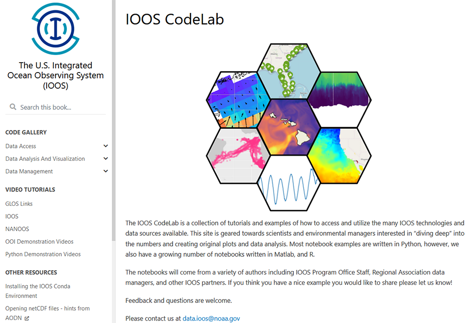
IOOS Provides Mentoring Services During Google Summer of Code
SUPPORTS NOS PRIORITIES: SAFE AND EFFICIENT TRANSPORTATION AND COMMERCE; PREPAREDNESS AND RISK REDUCTION
IOOS acted as an open source mentoring organization for Google's Summer of Code for the first time in 2021. The Summer of Code is a globally sponsored program in which students design their own projects that contribute to active development of open source software packages. IOOS selected three student projects for funding, all of which were accepted into the program. The students then worked closely with their mentors for 10 weeks in the summer, and the final results were delivered in early fall of 2021.
Screenshot, IOOS CodeLab site.
IOC Endorses Marine Life 2030 Program for UN Ocean Decade
SUPPORTS NOS PRIORITIES: PREPAREDNESS AND RISK REDUCTION; STEWARDSHIP, RECREATION, AND TOURISM
The Marine Life 2030 program was endorsed as a U.N. Decade of Ocean Science for Sustainable Development action. The ocean’s more than 200,000 species form the heart of ecosystems that provide protein, stable climate, protection, and livelihoods to billions of people worldwide. Many of these species, and the benefits that they provide, are threatened. Marine biodiversity is underrepresented and inadequately integrated into ocean observing systems worldwide. Marine Life 2030 aspires to solve that problem by establishing a globally coordinated system to deliver actionable knowledge of ocean life to those who need it, promoting human well-being, sustainable development, and ocean conservation.
Marine Life 2030 is made up of a global, collaborative team led by NOAA and IOOS, the Smithsonian Institution, and the Marine Biodiversity Observation Network in partnership with GEO BON, the Global Ocean Observing System, the Ocean Knowledge-Action Network, the Ocean Biodiversity Information System, and the World Conservation and Monitoring Centre. Marine Life 2030 engages many communities and organizations across the globe and, within a decade, will unite existing frontier technologies and partners into a global, interoperable network and community of practice to advance the observation and forecasting of marine life.
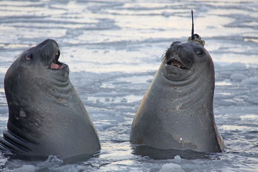
SUPPORTS NOS PRIORITIES: PREPAREDNESS AND RISK REDUCTION; STEWARDSHIP, RECREATION, AND TOURISM
A pair of southern elephant seals swim through Antarctic sea ice. One seal is outfitted with a tag that relays animal locations and oceanographic data via satellite to aid in understanding global climate and oceanographic processes. Credit: Clive McMahon.
Remote areas of the ocean are historically undersampled. As we continue efforts to understand the ocean, as well as its impact on climate variability and modeling, the need to study these remote areas is increasing. Marine animals equipped with sensors are helping to fill that gap, returning not only biological data but also hundreds of temperature-depth-salinity profiles a year. The Animal Borne Ocean Sensor (AniBOS) Network, a global ocean observing system-observations coordination group, is working to coordinate, aggregate, and manage metadata and data collections as well as implement best practices in this emerging area of study.
The IOOS-led U.S. Animal Telemetry Network (ATN) is the national contribution to the global AniBOS network, and is leading its real-time data collection and management strategy. The ATN achieved a significant milestone this year. It successfully demonstrated its Data Assembly Center’s capability to auto-ingest and deliver real-time, quality-controlled ocean profiles from animal-borne satellite tags onto the World Meteorological Organization Global Telecommunication System. This data is available to inform weather modeling and forecasting from the regional to global level.
 An official website of the United States government.

Social