NOAA’s National Geodetic Survey (NGS) provides the framework for all positioning activities in the nation. The foundational elements of latitude, longitude, elevation, and shoreline information impact a wide range of important activities.
US, Canada, Mexico Collaborate on Height Model
SUPPORTS NOS PRIORITY: SAFE AND EFFICIENT TRANSPORTATION AND COMMERCE
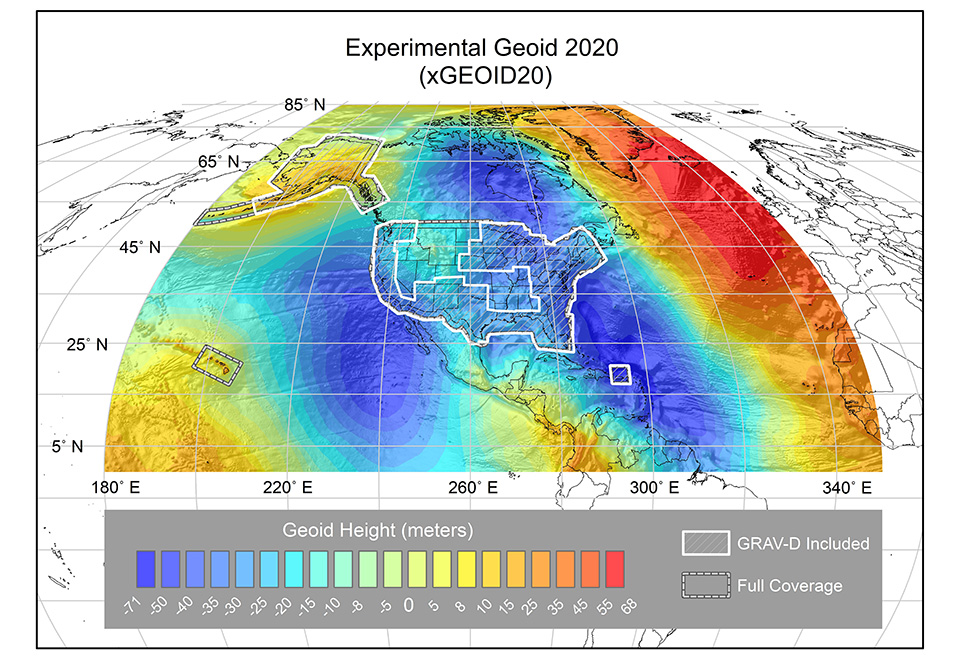
The geoid is a model of Earth’s shape that coincides with global mean sea level and considers the effects of gravity to measure precise heights. In June 2021, the Experimental Geoid Model 2020 (xGEOID20) — the first geoid model jointly computed by NGS, the Canadian Geodetic Survey of Natural Resource Canada, and the National Institute of Statistics and Geography of Mexico — was submitted to the International Service for the Geoid for validation and dissemination to the scientific community. This new experimental geoid model is the culmination of years of collaboration and joint data processing between the U.S., Canada, and Mexico, and heralds a new level of accuracy and inter-operation among the countries’ geospatial data models. The xGEOID20 covers all of North America. The new model provides improved accuracy and data for navigation, positioning, and the wide range of applications of geodesy, including: autonomous navigation, precision agriculture, civil surveying, natural disaster early warning systems, active remote sensing, coastal wetland monitoring, and floodplain mapping.
Graphical representation of the experimental geoid. showing measured gravity data and the differences in heights on a color spectrum.
NGS Releases New Guidance, Holds Summit on Modernized NSRS
SUPPORTS NOS PRIORITIES: SAFE AND EFFICIENT TRANSPORTATION AND COMMERCE; PREPAREDNESS AND RISK REDUCTION
The logo of the 2021 Geospatial Summit uses a map of the geoid as a backdrop.
To guide geospatial professionals through the coming modernization of the National Spatial Reference System (NSRS), NGS updated three important foundational blueprint documents that describe technical decisions about the definition of the new reference frames. NGS also hosted the virtual 2021 Geospatial Summit to share updates and discuss the progress of projects related to NSRS modernization with stakeholders.
Originally published from 2017 to 2019, the Blueprint for the Modernized NSRS Parts 1, 2, and 3 was revised in 2021 to reflect an updated timeline, the Geospatial Data Act of 2018, new NGS and United Nations standards, new NGS and industry technologies, and new concepts and expectations for the modernization process. Use cases were added to Blueprint Part 3, which covers working in the modernized NSRS.
The virtual 2021 Geospatial Summit drew more than 1,150 attendees on the first day, and nearly 1,050 attendees on the second day. Participants rated the summit's content as extremely informative, and the event as extremely satisfying. NGS also hosted 30 representatives from leading global survey equipment manufacturers and geospatial software developers for the virtual 2021 NSRS Modernization Industry Workshop.
NGS Develops Robotic System for Astronomical Measurements
SUPPORTS NOS PRIORITY: SAFE AND EFFICIENT TRANSPORTATION AND COMMERCE
TSACS hard at work beside a mountain stream.
Geodesists at the NGS Testing and Training Center in Woodford, Virginia, developed a new and innovative Total Station Astrogeodetic Control System (TSACS), a robotic system for measuring the direction of gravity by watching the stars. The TSACS was conceived, built, tested, and deployed by a four-person team in less than two years. The system can measure deflection of the vertical, a measurement of how much the direction of gravity is rotated by local anomalies (such as nearby mountains), in only 15 minutes. The previous labor-intensive method used to perform this task required an entire night of manual observations. The TSACS will make crucial measurements for defining a new, more accurate height standard for the nation.
The measurements made by TSACS will aid geoid studies and bridge the gap between classical and modern geodetic techniques. The system will be used to detect geoid and height change in Alaska for the Geoid Monitoring Service, which measures geoid changes over time.
NGS Increases Coastal Mapping, Gravity Data Collection in Alaska
SUPPORTS NOS PRIORITY: SAFE AND EFFICIENT TRANSPORTATION AND COMMERCE
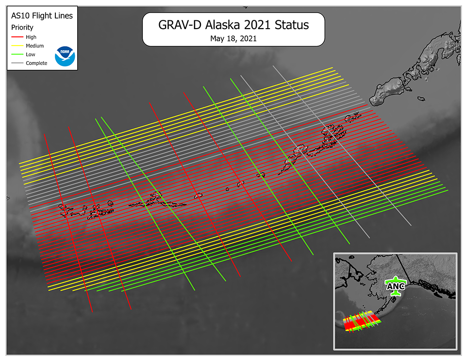
NGS overcame logistical and operational hurdles in Fiscal Year 2021 to fly 14 missions over the remote Aleutian Islands in Alaska for the Gravity for the Redefinition of the American Vertical Datum (GRAV-D) project. Mission work resulted in the collection of 52% of the total project data lines. During these missions, NGS surveyed approximately 202,000 square kilometers (78,000 square miles) — an area the size of Nebraska. The GRAV-D project is nearly 90% complete. The remaining 10% requires work in many challenging and remote locations. Completion of GRAV-D in Alaska will support the Alaska Statewide Digital Mapping Initiative. Maps of Alaska can be notoriously inaccurate, with entire mountains misplaced by miles, or too short by hundreds of feet. GRAV-D provides a vertical reference framework so that local changes to sea level can be compared against the global frame and provide a greater understanding of the causes of local signals.
NGS also increased its coastal mapping collection efforts in Alaska. Alaska shoreline information released to the public in FY 21 included the ports of Ketchikan, Petersburg, and Anchorage. NGS completed more than 12,874 kilometers (8,000 miles) of NOAA’s Continually Updated Shoreline Product in FY 21, which includes support of the vertical datum project requirements for an area covering over 35,405 kilometers (22,000 miles) for Kodiak and Egegik, as well as a contracted topobathy lidar survey.
Map depicting the lines flown (grey) during the NGS GRAV-D Alaska 2021 campaign over the Aleutian Islands. Remaining lines have been prioritized for maximum impact to NGS’s geoid models: red indicates top priority, yellow indicates medium priority, and green indicates low priority.
NGS Implements New Coastal Mapping Camera
SUPPORTS NOS PRIORITY: SAFE AND EFFICIENT TRANSPORTATION AND COMMERCE
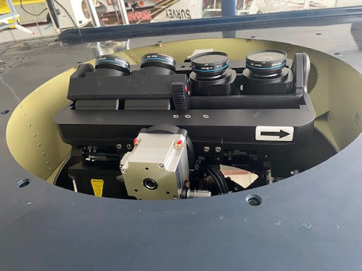
The four-lens array in the new coastal mapping camera system.
NGS completed acceptance of a new camera system. The camera system was used to conduct coastal mapping operations for two Coast and Shoreline Change Analysis Program projects in New Haven and New London, Connecticut, and for East Coast pre-event imagery from Portland, Maine, to Cape Lookout, North Carolina. NGS has two of the new camera systems. Images from the new system are twice as sharp and cover twice the area as images from the previous camera.
 An official website of the United States government.