SUPPORTS NOS PRIORITY: STEWARDSHIP, RECREATION, AND TOURISM
In 2019, NOAA’s Office of Response and Restoration (OR&R) reached multiple agreements that will require responsible parties across the United States to restore natural resources damaged from pollution. OR&R worked closely with NOAA’s Office of General Counsel Natural Resources Section, the National Marine Fisheries Service, and with many federal and state co-Trustees to reach these settlements. Seven case settlements yielded $28 million for the restoration of public natural resources, which will be used to build resilient habitats, bolster healthy fisheries, rebuild coral reefs, revitalize industrial waterways, improve public access to natural places, and make a real difference in communities across America.
Economic Effects of Marine Debris on Coastal Communities
SUPPORTS NOS PRIORITY: STEWARDSHIP, RECREATION, AND TOURISM
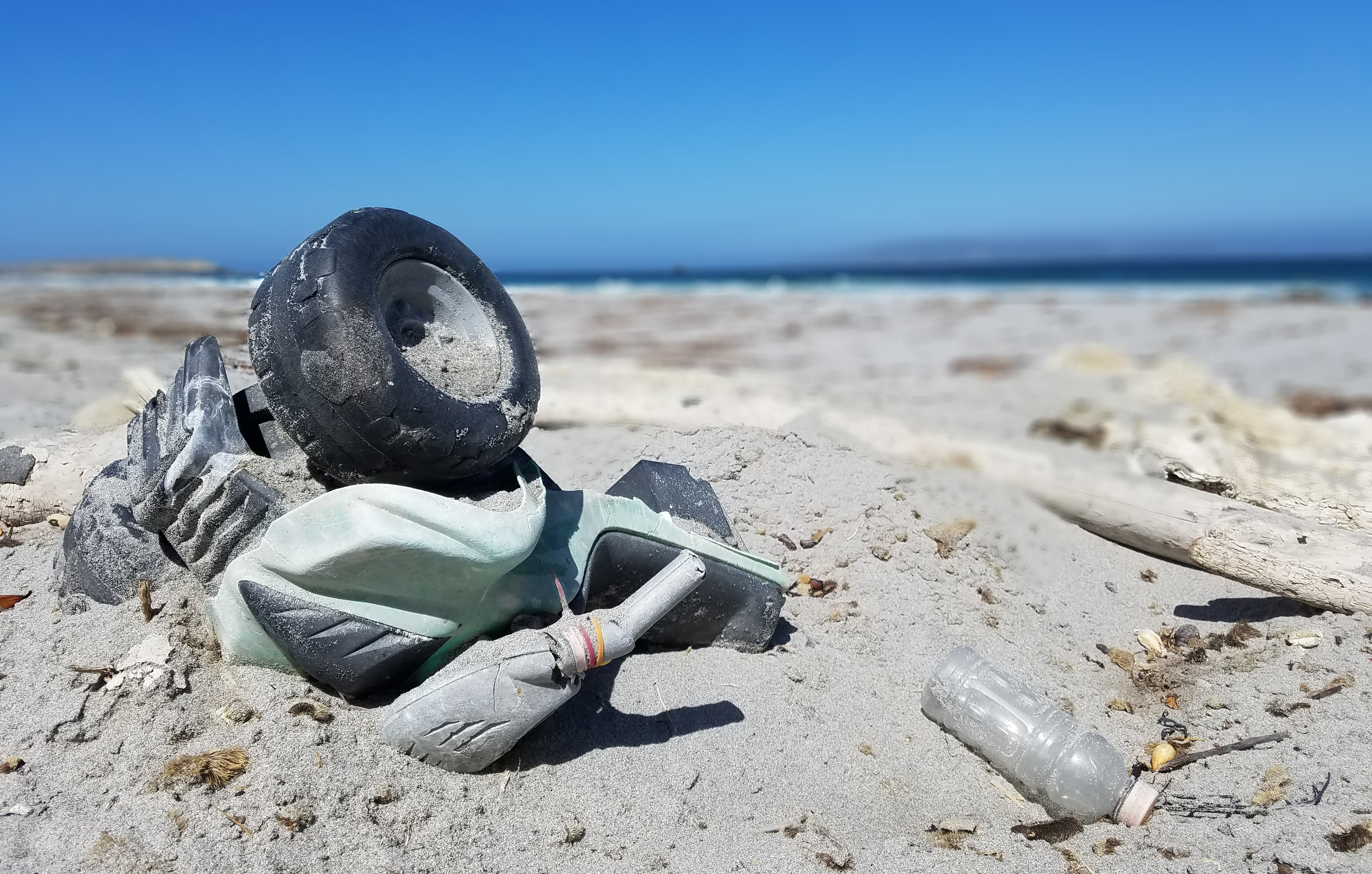
To better understand the relationship between coastal tourism economies and marine debris, the NOAA Marine Debris Program (MDP) funded a study to analyze how the amount of marine debris on beaches affects the behaviors of beachgoers, and the economies of coastal communities that depend on tourism. Results showed that if the amount of marine debris normally on beaches were doubled, coastal economies could experience a substantial negative impacts from a decrease in beach visits and loss of economic activity in those communities. For example, the largest potential economic loss was found in Orange County, California, where experts estimated that doubling the typical amount of debris could cause a $414 million decrease in local tourism-related spending and a loss of more than 4,200 jobs. Conversely, along Ohio’s Lake Erie shoreline, reducing marine debris to near zero could add an estimated $216 million in local, tourism-related spending, and more than 3,700 jobs. The results may help federal, state, and local agencies prioritize marine debris prevention and removal efforts and maximize the benefits provided by clean and healthy beaches and coastal resources.
Debris on Channel Islands Beach, California.
OR&R Carries Out Ambitious Year of Training and Workshops
SUPPORTS NOS PRIORITY: PREPAREDNESS AND RISK REDUCTION
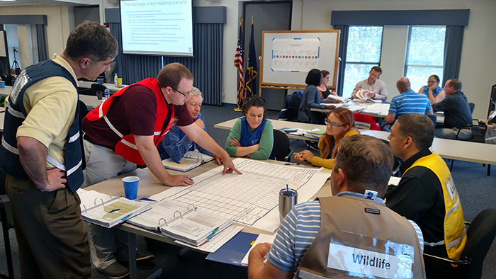
In 2019, OR&R's Disaster Preparedness Program (DPP) carried out its most ambitious training programs to date, including its first international offering. Training for a range of possible scenarios is the best way to prepare for disasters. The DPP provided scenario-based emergency preparedness, response, and recovery training for NOAA field responders, federal partners, and state and local emergency managers.
The DPP led the organization and facilitation of four Science of Oil Spill (SOS) classes and one Science of Chemical Releases (SOCR) class. The DPP implemented a virtual classroom for SOCR to connect to and train its Canadian partners — the first time OR&R has taught a multi-day international course remotely. The DPP also revitalized its NOAA Regional Preparedness Training Workshops, offering workshops for NOAA and its close partners in Puerto Rico and Norfolk, Virginia. The Puerto Rico workshop focused on disaster communications, and the Norfolk workshop examined the impacts of nuisance flooding and storm surge to NOAA’s mission. The DPP also organized, facilitated, and taught two NOAA-specific Incident Command Systems 300 courses. Through these courses and workshops, the DPP team taught over 300 students.
Attendees at NOAA-specific Incident Command Systems 300 course.
OR&R, USCG Mitigate Threats from Sunken WWII Tanker
SUPPORTS NOS PRIORITY: PREPAREDNESS AND RISK REDUCTION
Decades of leadership from OR&R scientists enabled the U.S. Coast Guard (USCG) to mitigate significant environmental threat from the sunken tanker Coimbra. The German military torpedoed Coimbra during World War II and the vessel sank off of Long Island, New York, carrying approximately 2.7 million gallons of lubricating oil. OR&R’s Emergency Response Division (ERD) helped identify the vessel as a risk while leading NOAA’s Remediation of Underwater Legacy Environmental Threats project, which assessed the risk and potential impacts of oil leaking from thousands of sunken vessels in U.S. waters. Using this threat assessment, ERD worked with the NOAA National Environmental Satellite, Data, and Information Service (NESDIS) to develop methods and implement monitoring of high risk sites, including the Coimbra. Those satellite observations showed sporadic oil sheens on the ocean surface and confirmed that the Coimbra was routinely leaking.
In response, the USCG led a multi-organization effort that successfully removed 99% of recoverable oil, thereby removing the spill threat and protecting trust resources. ERD provided scientific support for the response, leveraging numerous NOAA capabilities, including those of the National Weather Service Ocean Prediction Center and the National Marine Fisheries Service. Spill trajectories, risk analyses, and detailed spot forecasts for offshore operations were all critical. This accomplishment has rekindled interest in addressing other historic wrecks with oil still onboard.
U.S. Coast Guard crewmembers work alongside New York State Department of Environmental Conservation and Resolve Marine Group to help assess the condition of the Coimbra wreck: April, 2019. The Coimbra was a supply ship owned by Great Britain when the ship was sunk off the coast of Long Island, during World War II by a German U-boat. Image credit: U.S. Coast Guard.
Spatial Data Branch Provides the Foundation for OR&R Work
SUPPORTS NOS PRIORITY: PREPAREDNESS AND RISK REDUCTION
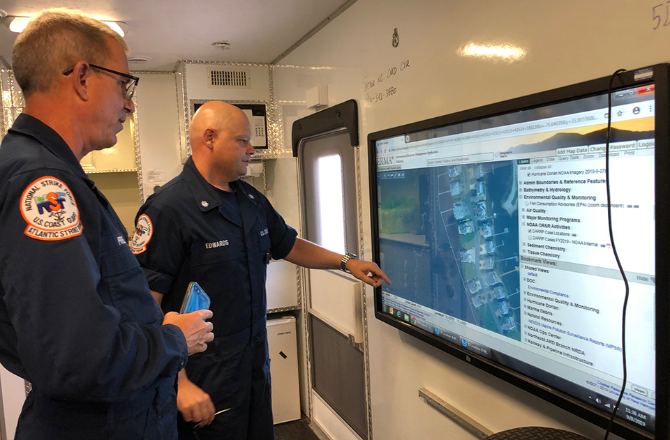
The Spatial Data Branch (SDB) provides a foundation for much of OR&R’s work. SDB ensures that incidents and case decisions are made using sound science by providing data that is available, shareable, and timely. The Environmental Response Management Application (ERMA) is a mapping and data sharing tool for environmental responders. In 2019, SBD trained over 500 colleagues to use ERMA to prepare for disasters and assess their impacts. Students included partners from federal agencies, 18 coastal states, industry, Non-Governmental Organizations, and the international community. ERMA has over 1,800 active users and was used over 35,000 times by emergency responders in Fiscal Year 2019.
The SDB also manages and shares complex data and document libraries for federal, state, tribal governments, and the academic community by using data from the Data Integration, Visualization, Exploration, and Reporting (DIVER) tool. Over 700 partners use DIVER, and this year they added more than 1,700 new documents to support pollution cases. DIVER contains the results from millions of field samples, and simplifies access and analysis of these data for work across OR&R.
The SDB is a model for cross-office collaboration by assisting NOAA’s Disaster Preparedness Program with trainings, deploying to oil spills with the Emergency Response Division, and partnering with the Marine Debris Program for regional collaboration portals and planning the removal of hurricane displaced vessels. The SBD’s work extends across the entire OR&R mission.
U.S. Coast Guard members use NOAA's Emergency Response Management Application (ERMA).
DPP Supports NOS Preparedness and Response to Dorian
SUPPORTS NOS PRIORITY: PREPAREDNESS AND RISK REDUCTION
OR&R’s Disaster Preparedness Program (DPP) supported NOS preparedness and response operations to Hurricane Dorian for 16 days. As the incident coordinators for NOS, DPP staff are responsible for coordinating across NOS program offices. They gather information on NOS mission readiness, logistical needs, and impacts to NOS personnel and infrastructure before, during, and after a disaster. During Dorian, the DPP coordinated information on the tracking and safety of more than 300 NOS staff, and the closure, impacts, and reopening of numerous sanctuaries, estuarine research reserves, office buildings, and laboratories. The DPP also coordinated the operational mission support provided by four NOS program offices. The DPP worked with NOAA’s Office of International Affairs and the White House to ensure that services, such as NGS aerial imagery flights, were executed without incident. The DPP also brought in OR&R mapping and communication support for the U.S. Coast Guard’s (USCG) Seventh District, supporting their deployment to the Bahamas.
OR&R tracked Hurricane Dorian as it moved through the Bahamas and assisted the USCG to prepare for impacts in Florida, Georgia, North and South Carolina, and Virginia. OR&R also supported the NOS Incident Management Team standup. At the request of the USCG, NOAA provided on-scene scientific support coordinators for USCG sectors Miami and Hampton Roads, and remote support to other sectors in the region. Flood waters in North Carolina sunk or stranded approximately 60 vessels and generated other pollution threats, but the overall impacts were relatively light. There was no disaster declaration and the USCG addressed pollution responses under the Oil Pollution Act and Superfund authorities.
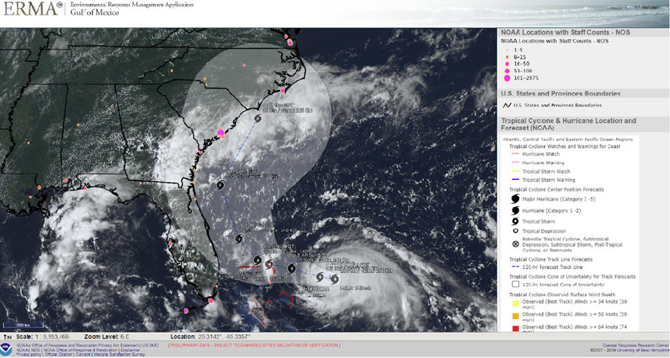
Environmental Response Management Application map of Hurricane Dorian: August, 2019.
OR&R Identifies Potential Pollution Sources Following Michael
SUPPORTS NOS PRIORITY: PREPAREDNESS AND RISK REDUCTION
In response to Hurricane Michael, OR&R reviewed aerial imagery and identified potential pollution sources, such as HAZMAT containers and displaced and sunken vessels. Using imagery from NOAA’s National Geodetic Survey (NGS), ingested into OR&R’s Environmental Response Management Application (ERMA®), over 540 vessels and other pollution targets were identified. Applying experience from Hurricane Florence, OR&R further streamlined the acquisition and display of field data in the command post through ERMA. The stranded and sunken vessels affected state parks and protected aquatic preserves, as well as coastal habitats such as marsh and seagrass. OR&R’s scientific support coordinators and other experts went on scene to mitigate further pollution, and to protect environmentally sensitive sites by providing operational oversight and scientific support. Staff from OR&R’s Marine Debris Program supported the removal of the displaced vessels and other debris. Post-storm salvage activities caused further impacts and the OR&R team worked with the U.S. Army Corps of Engineers to mitigate them by restoring seagrass habitats. The NOAA team demobilized in January, 2019, after over five months of field support, and continues to monitor the seagrass restoration.
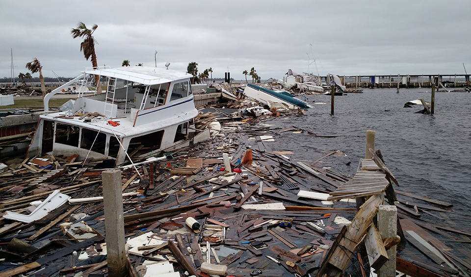
Displaced vessels, building materials, and other marine debris collect in a harbor in Panama City, Florida, following Hurricane Michael.
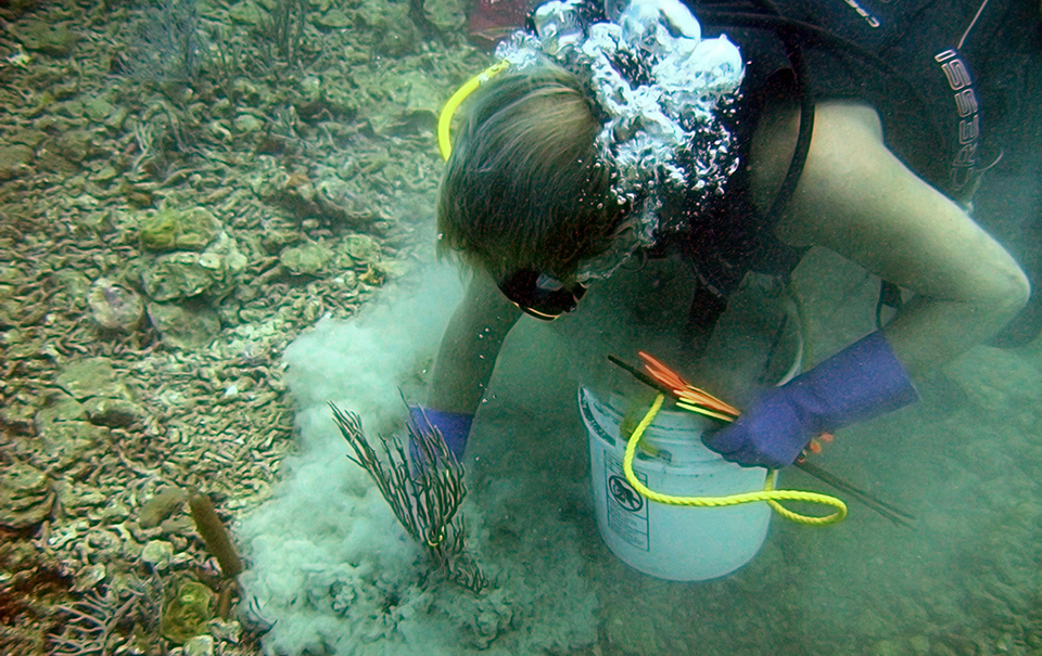
MDP Announces Supplemental Funding for Recovering Marshlands
SUPPORTS NOS PRIORITY: PREPAREDNESS AND RISK REDUCTION
In Fiscal Year 2019, NOAA’s Marine Debris Program (MDP) announced $17.2 million in grants to coastal states and territories impacted by Hurricanes Harvey, Irma, and Maria. These grant awards will aid coastal recovery efforts by supporting marine debris assessment, removal, and disposal. The disaster relief funding was provided by the Bipartisan Budget Act of 2018. MDP and partners made significant progress in storm debris removal in Georgia and South Carolina. The Georgia Department of Natural Resources and the South Carolina Department of Health and Environmental Control received disaster relief funding to remove storm debris from the state’s coastal counties. Removal efforts targeted vessels, construction materials, and floating docks that were submerged or lodged in coastal marshlands and tidal waters. Georgia removed over 8 million pounds of debris, including four vessels, and South Carolina removed over 100,000 pounds, including 13 vessels. Debris removal allows marshlands to regrow vegetation critical to habitat and for coastal protection.
 An official website of the United States government.
Social