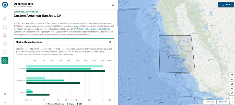
OceanReports lets users tap into more than 100 authoritative data sets at once for any part of the U.S. Exclusive Economic Zone. Shown here are ocean economic data for communities in San Jose, California.
OceanReports: A Planning Tool for All Ocean Industries
SUPPORTS NOS PRIORITIES: SAFE AND EFFICIENT TRANSPORTATION AND COMMERCE • PREPAREDNESS AND RISK REDUCTION
NOAA and its partners launched OceanReports, the most comprehensive web-based spatial assessment tool for U.S. ocean waters. The tool contains over 100 data sets of authoritative information, allowing users to analyze energy and minerals, natural resources, transportation and infrastructure, environmental conditions, and the local ocean economy within any area of the U.S. Exclusive Economic Zone. OceanReports is expected to create exciting opportunities for new industries like offshore aquaculture and renewable energy. The tool is designed to streamline permitting and decrease costs for all ocean industries, which add $320 billion to the U.S. economy.
The researchers also conclusively established that active releases from multiple wells at the site, rather than from contaminated sediments, are the primary source of the discharge entering the marine environment. Based on the NCCOS assessment, and other data, the U.S. Coast Guard installed a containment system at the site in February, 2019, that is collecting a significant portion of the oil being released.
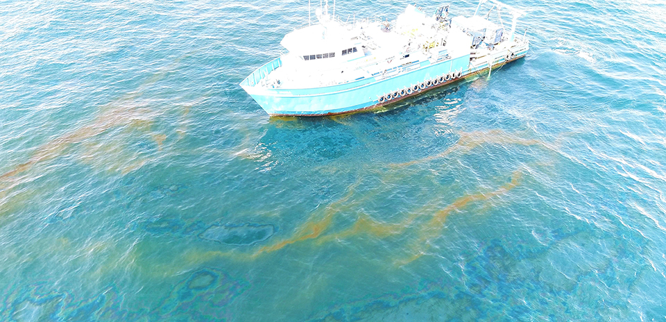
Since the collapse of the Taylor Energy drilling platform in 2004, the Mississippi Canyon 20 Site has been associated with persistent plumes of oil and gas and surface oil slicks, as shown here in September, 2018, during NCCOS’s data collection mission at the site.
New Harmful Algal Bloom Tools Help Inform and Protect the Public
SUPPORTS NOS PRIORITY: PREPAREDNESS AND RISK REDUCTION
In Pinellas County, Florida, NCCOS and its partners developed an experimental respiratory forecast that helps beachgoers, especially those with asthma and other chronic lung diseases, know the daily severity of airborne red tide toxins at area beaches during red tide events. The long-term goal is to expand the forecast to more beaches in Florida.
The respiratory forecast is part of a NOAA ecological forecasting initiative that aims to deliver accurate, relevant, timely, and reliable ecological forecasts directly to coastal resource managers and the public. NOAA and its partners provide harmful algal bloom (HAB) forecasts for Lake Erie, the Gulf of Maine, and the Gulf of Mexico. NCCOS is currently funding research in support of a pilot HAB forecast for the Pacific Northwest, including Puget Sound.
Also this year, NOAA launched an interactive online story map that documents the economic and social impacts of HABs, with data from almost 40 events, personal stories, and an overview of what NOAA is doing to support coastal communities affected by HABs.
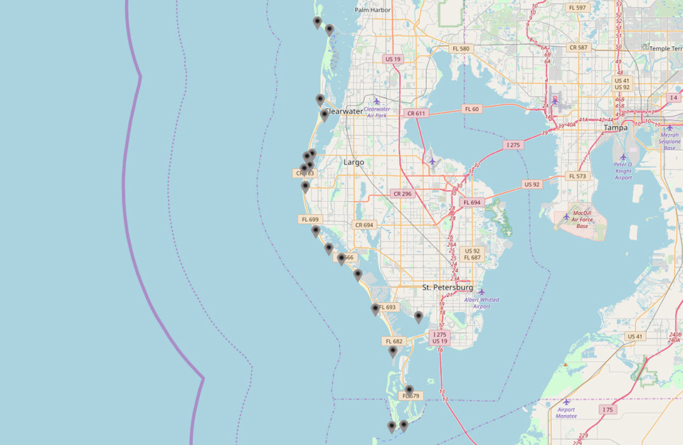
Map showing beaches included in the Pinellas County, Florida, experimental red tide respiratory forecast. Beachgoers can click on the black and gray markers to find out the respiratory risks associated with individual beaches during red tides. Credit: Gulf of Mexico Coastal Ocean Observing System.
NCCOS Researchers Evaluate Perceptions of Wind Energy
SUPPORTS NOS PRIORITY: STEWARDSHIP, RECREATION, AND TOURISM
NCCOS researchers used survey data to assess the social values and opinions that coastal residents in North and South Carolina have about offshore energy development. The research addresses information gaps concerning the perceived effect of offshore wind energy development on coastal communities.
The mail-based survey collected information about residents’ attitudes, beliefs, and values regarding marine and coastal landscapes, alternative energy options, and offshore wind energy development. The team delivered the survey results to the Bureau of Ocean Energy Management (BOEM) in late spring of 2019 to inform BOEM’s decisions regarding several offshore areas in the Carolinas under consideration for wind energy development. The assessment is expected to enrich BOEM and NOAA’s understanding of the likelihood of community action to support or oppose renewable energy projects, including offshore wind energy.
Wind turbines off the coast of Block Island, Rhode Island. Credit: Rhode Island Sea Grant.
Helping Coastal Communities Plan for Sea Level Rise
SUPPORTS NOS PRIORITY: PREPAREDNESS AND RISK REDUCTION
Projects funded through NCCOS’s Competitive Research Program are helping coastal communities adapt to sea level rise. In the Gulf of Mexico, an NCCOS-funded team modeled what hurricane storm surge may look like with projected sea level rise. Emergency planners are using the data to inform development of infrastructure and evacuation routes in the region. Also, the Northern Gulf of Mexico Sentinel Site Cooperative is using NCCOS-funded informational videos on sea level rise planning to engage and educate local elected officials, business owners, and residents on ways to prepare for increasing storm surges and coastal flooding.
In Hawaii, NCCOS-funded researchers developed a sea level rise projection application for coastal managers to visualize the impacts of future development and rising sea levels on anchialine pools, and to prioritize restoration and conservation of the pools over time. Shrimp that reside in these coastal pools are culturally important bait, and are at risk.
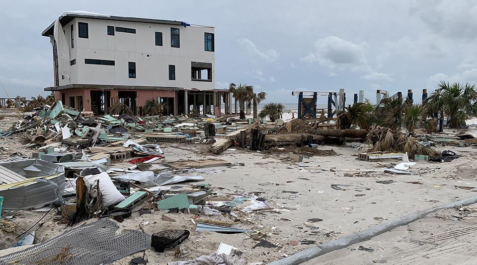
Hurricane Michael storm surge damage on Mexico Beach, Florida (2018).
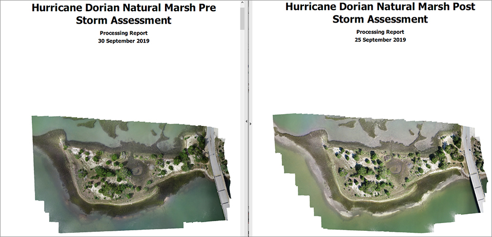
NCCOS Scientists Assess Impacts of Hurricane Dorian
SUPPORTS NOS PRIORITY: PREPAREDNESS AND RISK REDUCTION
Scientists at the NCCOS Beaufort Lab were involved in several efforts to assess the impacts of Hurricane Dorian on eastern North Carolina coastal wetland habitats and nature-based infrastructure. NCCOS deployed feldspar maker horizons at three long-term marsh monitoring sites on Pivers Island, North Carolina, the day before Dorian's passage. Post-Dorian, scientists measured the depth of sediment deposition that occurred at all three monitoring sites: sill-stabilized, restored, and natural fringing marshes on Pivers Island. Sediment deposition and accretion was found at all three sites, averaging 1 to 7 millimeters. An Unmanned Aerial System was also used to obtain before and after storm imagery of the Pivers Island marshes to further assess impacts on marsh shorelines and vegetation. NCCOS collaborated with the National Park Service (NPS) to plan marsh Surface Elevation Table measures on Cape Lookout National Seashore in Harkers Island, North Carolina, where the storm created 50 new mini-inlets between the ocean and Pamlico Sound on North Core Banks. NCCOS and NPS are working to measure changes in marsh surface elevation as a result of this tremendous sediment transport event.
Before and after imagery of Hurricane Dorian taken by an unmanned aerial system in Pivers Island, North Carolina.
 An official website of the United States government.

Social