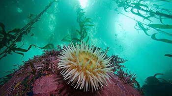
Sea anemone in the kelp beds of Monterey Bay National Marine Sanctuary, one of the sites of the 3 pilot Marine Biodiversity Observing Networks (MBON). Photo Credit: Chad King/MBNMS
The U.S. Marine Biodiversity Observing Network (MBON)--a partnership funded by U.S. IOOS®, NOAA's Office of Ocean Exploration and Research, NASA, and the Bureau of Ocean Energy Management (BOEM) has had a successful second year. Researchers are working toward establishing a long-term national biodiversity monitoring network, through three pilot projects. The projects are working in the Arctic Chukchi Sea, the Santa Barbara Channel, and the Florida Keys, Flower Garden Banks, and Monterey Bay National Marine Sanctuaries. The Arctic Marine Biodiversity Network (AMBON), a partnership with a number of regional initiatives (including the NOAA-led Distributed Biological Observatory), was selected as one of the projects that will support deliverables from the White House Arctic Sciences Ministerial, taking place in fall 2016. The Sanctuaries MBON project extended to include Flower Garden Banks. Work in the Flower Gardens is timely, and MBON researchers are contributing to understanding of the unprecedented coral bleaching event happening there. An increase in availability of time-series data will make this event, and future events, easier to understand and forecast. In the Santa Barbara Channel MBON project, researchers are developing new technology and data handling methods to identify and fill data gaps.
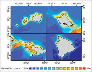
Modeled long-term relative abundance of Humpback whale around Main Hawaiian Islands in winter. Credit: NOAA and University of Hawaii at Manoa
NOAA continues to work closely with the Bureau of Ocean Energy Management (BOEM) to develop mapping products that support ocean energy development. Accurate maps and predictions of living marine resource distributions facilitate planning that reduces potential conflicts between human uses and sensitive marine ecosystem components needed for healthy and resilient coastal communities and economies.
In 2016, NCCOS scientists published an environmental assessment of the distribution of marine animals and benthic habitats around the main Hawaiian Islands, with special consideration given to species likely to interact with renewable energy infrastructure. These data will serve as foundational material for BOEM’s renewable energy leasing process and help identify potential issues for future National Environmental Policy Act (NEPA) analysis as Hawaii strives to generate 100 percent of its electricity from renewable energy sources by 2045.
Also in 2016, NCCOS and BOEM published an ecological study of the seafloor in a proposed offshore wind energy area off the coast of North Carolina. BOEM used these findings to modify the size and boundaries of the original area of interest to minimize possible impacts to sensitive reef and fishery habitats.
This year, the NOAA Coral Reef Conservation Program completed a science evaluation to gain a better understanding of how the data, tools and products it provides are used by stakeholders. A panel of leading, independent coral reef experts investigated the accessibility of the information to coral reef managers and policy makers, how helpful these products are for coastal management decision makers, and how the data, information, and services are being used to support coral reef conservation. This review covered NOAA Coral Reef Conservation Program-funded ecosystem science only. Reports from the panelists and the program’s response, including an action plan for program adjustments based on panelists' recommendations, are available on the program’s web site.
NOAA’s coral reef research portfolio was well represented at the 13th International Coral Reef Symposium in Honolulu Hawaii
NOAA’s coral reef research portfolio was well represented at the 13th International Coral Reef Symposium (ICRS) in Honolulu Hawaii with researchers joining sessions and media events on the conservation, restoration, policy, and science of coral reef and associated habitats. ICRS organizers also hosted a Leader’s Summit with the presidents of the Federated States of Micronesia, Palau and Republic of the Marshall Islands. These leaders issued a call to action requesting increased collaboration between the scientific community and local governments, acknowledging there needs to be more funding and a strengthened commitment to protecting coral reefs. ICRS is the largest international meeting focused on coral reef science and management. It was hosted by the International Society for Reef Studies and was sponsored by the NOAA Coral Reef Conservation Program. The symposium takes place every four years.
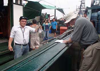
A NOAA scientist works with the Philippines Bureau of Fisheries and Aquatic Resources to ground truth light signatures of fishing lights detected using visible infrared imaging technology.
2016 marked the third year of a $20 million dollar partnership between NOAA and the USAID Regional Development Mission for Asia to strengthen local marine conservation in an area with some of the planet’s most diverse marine habitats. NOAA provided trainings on:
Ecosystem approaches to fisheries management in the Philippines,
Marine protected area management in the Philippines and Indonesia,
Development of sustainable marine tourism in Indonesia, and
Methods and technologies, like visible infrared imaging, to enhance marine enforcement in the Philippines and Indonesia.
The NOAA Coral Reef Conservation Program coordinates the agency’s engagement in international coral reef issues. NOS, NMFS, OAR, and NESDIS play a key role in implementing the trainings that are core parts of this five-year partnership with USAID.
The redesigned www.coralreef.noaa.gov now makes learning about NOAA’s coral reef research easier.
Educating the public on the value of coral reef ecosystems and the threats they face in a changing environment is key to their conservation. In 2016, the NOAA Coral Reef Conservation Program continued efforts to engage the public in order to move the conservation needle in a positive direction. In the spring, the program launched its newly redesigned web site, www.coralreef.noaa.gov. With web stories, featured data products from the Coral Reef Information System, and a multimedia library, the site lets visitors dive right into what the NOAA coral reef research community is doing on the ground and in the water. The program also joined the Twittersphere, highlighting the latest news, findings, images and videos on @NOAACoral, and grew its following on Facebook to over 50,000 supporters. Successful efforts to draw media attention to the ongoing threat of coral bleaching and what the agency is doing to address it continued with press conferences, interviews with the media, the development of infographics, and a popular “Ask Us Anything” session on “Coral bleaching and why there’s hope”, that drew over 7.6 million Redditors.
A diver collects data on the condition of coral reefs in the Mariana Islands
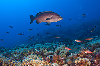
Scientists collected biological, climatic, and socioeconomic data in 2016 to measure changes in U.S. coral reef ecosystems as part of the National Coral Reef Monitoring Program. In the Hawaiian Archipelago, NOAA scientists conducted hundreds of fish and benthic surveys and recovered and re-deployed instruments to assess impacts of ocean acidification and warming. In the Atlantic, scientists gathered similar data at sites in Puerto Rico and Florida. Social science researchers focused on the connections between coral reef ecosystems and people, their communities and economies by completing resident surveys in Guam and the Northern Marianas Islands. Satellite remote sensing provided data across all U.S. reef areas, filling gaps between field sampling sites. The National Coral Reef Monitoring Program is an integrated and focused monitoring effort with partners across the U.S. and its territories. Outcomes will help managers, decision makers, and communities better understand the condition of their resources and take effective place-based conservation actions.
Map showing the expanded area of Papahānaumokuākea Marine National Monument. The new boundary extends out to the U.S. EEZ (shown in purple). The monument's original area is shown in blue
On August 26, 2016, President Obama signed a proclamation expanding Papahānaumokuākea Marine National Monument. Previously the largest contiguous fully-protected conservation area in the United States at 139,797 square miles (362,073 km2), the expanded boundaries make it once again the biggest protected area on the planet at 582,578 square miles (1,508,870 km2), nearly the size of the Gulf of Mexico. Papahānaumokuākea is globally recognized for its biological and cultural significance, being the only mixed UNESCO World Heritage site in the United States and only one of 35 mixed sites in the world. This expansion not only provides direct protection to this global resource, but also brings critical attention to the need for increased ocean conservation and protection worldwide. Despite its remote location in the Northwestern Hawaiian Islands, PMNM faces a looming threat of global climate change that will affect its land and marine ecosystems, as well as its cultural resources -- a threat that ocean resources are facing across the globe.
USS Monitor. This famed Civil War ironclad sank during a storm on December 31, 1862, and wasn't found again until 1973. Its discovery prompted the creation of our first national marine sanctuary, Monitor National Marine Sanctuary! Photo Credit: NOAA Monitor Collection
For more than 40 years, Monitor National Marine Sanctuary has served as a special place honoring the iconic Civil War ironclad, USS Monitor, and the memory and service of Civil War sailors. The proposed expansion, announced in January 2016, is an opportunity to honor another generation of mariners that helped defend the nation during both World Wars. An expansion of this historical site just off of North Carolina’s coast would protect a collection of historically significant shipwrecks vessels, including vessels sunk during World War II’s Battle of the Atlantic.
Building on more than 30 years of scientific studies, including numerous reports released in the last decade and in the aftermath of the 2010 Deepwater Horizon oil spill, NOAA announced in June 2016 to expand Flower Garden Bank National Marine Sanctuary. The preferred scenario would cover an extra 383 square miles, including 15 reefs and banks that provide habitat for recreationally and commercially important fish, as well as 15 threatened or endangered species of whales, sea turtles, and corals. This scenario also calls for comprehensive management and protection of these important habitat sites and cultural resources, and would provide more opportunities for research and recovery of resources.
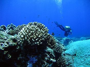
Red grouper and boulder star coral photographed in the Upper Keys, at Florida Keys National Marine Sanctuary
Less than a hundred miles south of the reefs and mangrove forests of Florida Keys National Marine Sanctuary are the marine ecosystems of our neighboring nation, Cuba. In November 2015, a Memorandum of Understanding (MOU) was signed by NOAA, the National Park Service, and Cuba’s Ministry of Science, Technology, and Environment. This new MOU includes the establishment of sister-sanctuary relationships between Guanahacabibes National Park in Cuba, including its offshore Bank of San Antonio, and Florida Keys and Flower Garden Banks national marine sanctuaries in the United States.
Recognizing that these protected areas are all inextricably linked by ocean currents and animal migrations, and threatened by some of the same environmental stressors (such as ocean acidification), this MOU is an opportunity for marine protected area managers and scientists in the U.S. and Cuba to learn from one another’s experiences, benefiting and improving the health of coral reef resources in both countries.
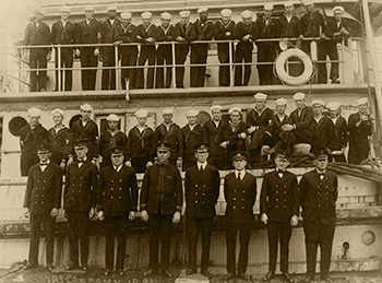
The officers and crew of USS Conestoga, in San Diego, California in 1921.Credit: Naval Historical Center Photograph NH 71503
"In remembering the loss of the Conestoga, we pay tribute to her crew and their families, and remember that, even in peacetime, the sea is an unforgiving environment," said Dennis V. McGinn, Assistant Secretary of the Navy for Energy, Installations and Environment. In March 2016, NOAA and the U.S. Navy announced the discovery of theUSS Conestoga (AT 54) in the Greater Farallones National Marine Sanctuary, 95 years after the Navy tugboat disappeared with 56 officers and sailors aboard.
The process leading up to the final discovery began in 2009, when NOAA’s Office of Coast Survey documented a probable, uncharted shipwreck. In September 2014, NOAA launched a two year investigation to document historic shipwrecks in the Greater Farallones National Marine Sanctuary and nearby Golden Gate National Recreation Area. Finally, in October 2015, NOAA confirmed the identification and location ofConestoga. In recognition of this historical discovery, ONMS released a short documentary, “Three Miles from Safety: The Story of theUSS Conestoga,” on Memorial Day in May 2016, honoring the memory of the naval veterans who perished on board. This discovery solves one of the top maritime mysteries in U.S. Navy history.
The U.S. has identified advancing marine protected areas (MPA) networks as a priority under its chairmanship of the Arctic Council during 2015-2017. The Arctic is experiencing rapid changes due to climate impacts, including receding sea ice which will open sensitive ecosystems to human uses. While MPAs are effective marine conservation tools, many stakeholders in Alaska are concerned about potential restrictions on access to ocean resources. To provide an opportunity for dialogue and consensus building on this issue, NOAA and the Department of the Interior asked the MPA Federal Advisory Committee to develop guidance on MPAs and MPA networks in the Arctic. The “Guiding Principles for Marine Protected Areas and MPA Networks in the Arctic” were developed by the Committee’s Arctic MPA Working Group, representing diverse U.S. Arctic stakeholders. The “Guiding Principles” note the impacts and implications of climate change already being felt, the role of MPAs as a conservation tool, and strongly emphasize the importance of engagement with Alaska Natives and local stakeholders.
The inaugural issue of Earth is Blue: Magazine of the National Marine Sanctuaries was released in June 2016. Following on the footsteps of ONMS’ social media campaign Earth is Blue, the magazine covers a broad range of topics and everything that the sanctuary system has to offer. The beauty and economic benefits of our country’s underwater parks are highlighted through mesmerizing photographs and stories. Expect to learn about our nation’s indigenous cultures, maritime heritage, conservation of vital marine areas and the wide variety of recreational activities that visitors can enjoy responsibly. The Earth is Blue: Magazine of the National Marine Sanctuaries is available in hard copy and online.
Supports NOS priority: Place-Based Conservation Priority
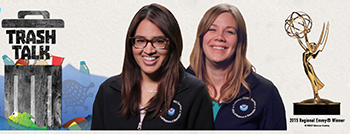
The “Trash Talk” series is an excellent tool for educators that includes hands-on exercises
Ocean Today teamed up with the NOAA Marine Debris Program to create the widely-successful 15-minute video, “Trash Talk”, which explains what marine debris is, how it affects our ocean, and what people can do to prevent it. Nominated by the National Capital Chesapeake Bay Chapter of the National Academy of Television Arts and Sciences, the video received a Regional Emmy® in the category of Informational/Instructional Program or Special. This is exciting recognition of outstanding work and an important acknowledgment of the value of increasing public awareness about the issue of marine debris.
NOS uses its online presence to reach the ocean-interested public. Traffic to the NOS websiteincreased 38% during FY 2016 compared to FY 2015; monthly website traffic peaked at an all-time high 2.4 million visits in May, 2016. The number of Facebook “likes” grew more than 57% (from 64,413 to 101,262) and the number of Twitter followers grew more than 13% (from 129,480 to 146,820). During its 30-day National Ocean Month campaign, NOS reached more than1.4million users on Facebook. Alsoin FY 2016, NOS completed several Reddit 'Ask Us Anything' sessions featuring NOS scientists.The AUA on Harmful Algal Blooms reached an estimated 10.36 million people and includedmore than 180 questions.NOS launched its Instagram in June 2015, which closed out FY 2016 with 13,060 followers.
 An official website of the United States government.
Here's how you know we're official.
An official website of the United States government.
Here's how you know we're official.