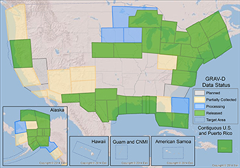
GRAV-D reaches 50 percent milestone of gravity completion.
The National Geodetic Survey’s (NGS) Gravity for the Redefinition of the American Vertical Datum (GRAV-D) project is covering the United States and its territories with airborne gravity measurements to facilitate the creation of a new national vertical reference system slated for launch in 2022.
In FY2016, GRAV-D achieved the major milestone of having surveyed more than 50 percent of the total project area. With each one percent of the project area equating to approximately 100 flight hours, GRAV-D has collected and processed data from a total of about 5,000 flight hours. More than three million square miles of data collection and processing have been completed across the continental United States, Alaska, Puerto Rico and the U.S. Virgin Islands.
The new vertical reference system scheduled for release in 2022 will be built upon GRAV-D airborne gravity data, together with both terrestrial and satellite data. Once implemented, GRAV-D will provide an estimated cost savings of $4.8 billion to the Nation from infrastructure cost savings, inundation models for storm surges and tsunamis, and coastal intelligence and resilience initiatives for communities.
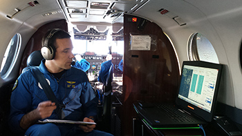
LT Scott Broo acquiring aerial imagery aboard the NOAA King Air aircraft.
In August 2016, NGS collected imagery to assist federal, state, and coastal managers in assessing damage from flooding in Louisiana. At the request of the Federal Emergency Management Agency and NOAA’s National Weather Service, NGS collected imagery using coastal mapping and emergency response aircraft, and more than 2,000 images were made available for the public. NGS aerial imagery is a crucial tool to assess the damage to major ports and waterways, coastlines, critical infrastructure, and coastal communities. This imagery provides a cost-effective way to better understand the damage sustained to both property and the environment. NGS concluded topographic bathymetric (‘topo-bathy’) light detection and ranging (lidar) data collection along the outer reef of Florida using the Office of Marine and Aviation Operation’s Twin Otter aircraft equipped with NGS’ newly-acquired Riegl high-resolution nearshore lidar system. Data collected will support nautical charting and will be used by the Florida Keys National Marine Sanctuary for bathymetry maps. NGS produces the national shoreline to provide critical baseline data for updating nautical charts, defining our Nation’s territorial limits, and managing our coastal resources. Additionally, the shoreline supports maritime trade and transportation, coastal engineering and spatial planning, and a multitude of activities for enhancing our global competitiveness and managing our resources.
An accurate, consistent, and up-to-date national shoreline provides data to model sea level change, storm surge, coastal flooding, and pollution trajectories and improves environmental analysis and monitoring.
The National Geodetic Survey (NGS) hosted a five-day Airborne Gravimetry for Geodesy Summer School. The school brought experts from around the world to share their knowledge pertaining to airborne gravity data collection and processing techniques and its application to geodesy and geophysics. Sixty-five participants from 12 different countries, including Germany, Spain, and Saudi Arabia, to name a few, took part in the training.
World-renowned subject matter experts from NGS and beyond provided lectures on the overarching theme of airborne gravimetry. Lecture topics covered the history and fundamentals of airborne gravimetry, airborne gravity data collection and processing, geoid modeling using airborne gravity, the emerging developments in airborne gravimetry for geodesy, and time-varying gravity and the geoid.
This free-of-charge educational program covered topics integral to NOAA’s mission and of great interest to the international scientific community. Lecturers provided technical information on conducting measurements of Earth’s gravity field from aircraft and combining that information with other data sources to create the geoid. The school also covered talks on recent advances in gravity measurement technology and aircraft positioning. Presentation materials and recorded lectures from the school are available on the NGS website.
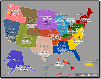
Map depicting the regional advisors and their designated territories.
The National Geodetic Survey (NGS) recently transitioned from a state advisor program, covering only 24 participating states, to our new Regional Advisor Program covering the entire United States. Regional geodetic advisors serve as liaisons between NGS and our public, academic, and private sector constituents within their assigned regions, to ensure all territories are covered.
Regional advisors provide expert guidance to constituents who manage geospatial activities that are tied to the National Spatial Reference System (NSRS). Geodetic advisors serve as subject matter experts on geodetic issues in their region and collaborate internally across NGS and NOAA to further the mission of the organizations. This transition to a regional program is particularly important, as NGS plans to replace the North American Datum of 1983 (NAD 83) and the North American Vertical Datum of 1988 (NAVD 88) by 2022, when our Gravity for the Redefinition of the American Vertical Datum (GRAV-D) project will be completed. During this period of change, every state will need the direct support and technical assistance provided by their regional advisor.
The monthly webinar series now averages more than 130 attendees from across the country each month and has reached over 1,527 participants. Topics presented range from an overview of scientific principles (e.g. terrestrial gravity and space weather) to examples of NGS products and services (e.g. topobathy lidar and VDatum).
NGS has also dramatically increased the accessibility of OPUS Projects training across the country by providing an online delivery option. By expanding the use of OPUS Projects, we enable our customers to conduct survey work more effectively and efficiently.
 An official website of the United States government.
Here's how you know we're official.
An official website of the United States government.
Here's how you know we're official.