The Ports Resilience index is a user-friendly tool for maintaining port and marine transportation operations during and after disasters
Ports play an important role in waterfront community resilience. A new tool, the Ports Resilience Index, is a simple and inexpensive means of undertaking a readiness assessment for maintaining port and marine transportation operations during and after disasters.
Ports that have completed this self-assessment include the Port of Corpus Christi Authority in Texas, the Jackson County Port Authority Mississippi, the Port of Lake Charles Harbor and Terminal District in Louisiana, and Port Tampa Bay in Florida. The Office for Coastal Management funded this project, which was a partnership effort led by the Gulf of Mexico Alliance and coordinated by the Louisiana Sea Grant. Other partners included Mississippi-Alabama Sea Grant, Dewberry, seven Gulf of Mexico ports, the Gulf Ports Association of the Americas, and industry partners. The nation’s seaports move over $1.5 trillion in cargo each year, supporting port-side employment of more than 420,000 persons that pays $30 billion in wages each year. Keeping ports safe (and working) represents an important aspect of the nation’s economic health.
Several years ago Ft. Lauderdale was a pilot community in a National Coastal Zone Management Program initiative focused on preparing communities for sea level rise and coastal flooding. New policies were enacted that included infrastructure improvements and incorporating sea level rise projections into the design of new construction capital projects. This baseline effort continues to pay dividends today, as the city’s FY2017-2021 Proposed Community Investment Plan identifies 16 adaptation action areas and 40 projects identified for funding. These projects include stormwater, park, and seawall repairs and improvements. A public survey associated with these efforts found 75% of the respondents saying they had observed coastal water level increases and 72% have observed increased flooding.
While NOAA is the nation's premier coastal science information agency, simply providing the information is not enough. Over 5,000 professionals took advantage of the coastal management educational opportunities provided by NOAA’s Office for Coastal Management. Follow- up surveys revealed that 71 percent of the 1,600 professionals who participated in the formal training programs are using their new skills to make coastal communities more resilient. Over 3000 people engaged in peer-to-peer learning at various events such as the Pacific Risk Management 'Ohana (PRiMO) conference, workshops focused on FEMA’s Community Rating System, the Social Coast Forum, and “Our Florida Reefs,” a community planning initiative. Technical assistance was also provided via three fellowship programs.
Infographic showing application and benefits of green infrastructure
Green infrastructure, the use of nature-based solutions to minimize flooding, is gaining traction throughout the coastal zone. NOAA’s Office for Coastal Management provided funding ($410,000) and assistance to develop an information tool that is guiding green infrastructure investments in Staten Island and Jamaica Bay. The tool incorporates research on green infrastructure performance during Post-Tropical Cyclone Sandy, and integrates data on future flooding scenarios, vulnerable populations, and critical infrastructure. The tool is being used by The Trust for Public Land and the City of New York to identify the most suitable and effective green infrastructure investment locations, as they made decisions about the best way to use the $176 million in disaster resilience funds New York received from the U.S. Department of Housing and Urban Development.
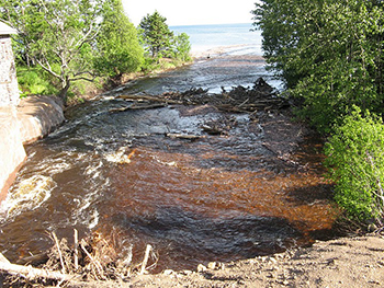
Heavy precipitation event caused riverine flooding, and erosion and runoff into Lake Superior in 2008
Wisconsin and Minnesota are working together to make coastal communities safer. Recent Wisconsin legislation requires coastal communities to create resilience plans, and the state identified green infrastructure (nature-based approaches) as a viable alternative to seawalls and other built structures. The Lake Superior National Estuarine Research Reserve provided scientific research and expertise, and helped create the partnerships communities needed to successfully apply for funding assistance. One of these partners was the city of Duluth, Minnesota, as this city was also seeking green infrastructure solutions. The reserve used both social and natural science to provide the information needed, and the two states developed a successful joint application for a NOAA-funded project.
 An official website of the United States government.
Here's how you know we're official.
An official website of the United States government.
Here's how you know we're official.