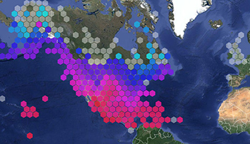
Wide view of the Environmental Sensor Map showing hexagonal bins clustering data points, which can be selected at an individual level when zoomed in.
In FY 2016, U.S. IOOS® launched new tools to expand the availability and discovery of integrated ocean observing data. The IOOS collection page debuted on the Office for Coastal Management's Digital Coast site. This provides coastal communities quick and easy access to coastal and oceanographic datasets via connectivity to IOOS's 11 Regional Associations (RAs), which provide observations from areas along the U.S. Coast, Great Lakes, and Pacific territories. Previously only available via individual points of entry, exposing these RA data linkages to Digital Coast users through a single cohesive collection enables quicker and more comprehensive access to national ocean observing resources.
The Environmental Sensor Map displays real-time environmental data collected from over 31,000 stations throughout the world, including the 11 IOOS RAs. The map provides an expansive, integrated visualization of aggregated real-time data, which is useful during storm events where extreme values may display a 'bulls-eye' in one area of the nation. This tool accesses and loads an enormous amount of data from myriad observing networks with minimal load time that means more information faster when it's needed most, at any time.
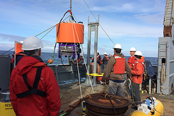
Deploying the Environmental Sensor Processor near the Juan de Fuca eddy in the Pacific Northwest in May, ahead of HAB season. Photo Credit: NOAA/UW
May 2016 saw the deployment of the Environmental Sample Processor (ESP) to monitor and provide early warning for harmful algal blooms (HABs) on the West Coast, following successful deployments in the Gulf of Maine. The Pacific Northwest deployment was undertaken through a U.S. IOOS Ocean Technology Transition project [grant] and led by the University of Washington’s Applied Physics Lab. The ESP—a robotic, marine biosensor developed by the Monterey Bay Aquarium Research Institute (MBARI)—automates sampling and testing and transmits data in near-real time, addressing an accessibility issue that has previously hindered offshore observation. Continuous offshore sampling and data transmission enables earlier detection of HABs, thereby allowing communities and businesses more time to mitigate the impacts.
Originally scheduled for deployment in August 2016, the Washington State Department of Fish and Wildlife and other end-users requested a spring launch following the devastating 2016 West Coast HAB that occurred earlier in the season. A multi-agency team from NOAA (NCCOS & Northwest Fisheries Science Center), IOOS, and the University of Washington came together to make that launch happen, and the new ESP was successfully deployed May 23 on a mooring within the Olympic Coast National Marine Sanctuary near the Juan de Fuca eddy, a known HAB hotspot. The resulting data are the first near-real time ESP observations publically available to end-users in near-real time on the west coast.
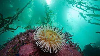
Sea anemone in the kelp beds of Monterey Bay National Marine Sanctuary, one of the sites of the 3 pilot Marine Biodiversity Observing Networks (MBON). Photo Credit: Chad King/MBNMS
The U.S. Marine Biodiversity Observing Network (MBON)--a partnership funded by U.S. IOOS®, NOAA's Office of Ocean Exploration and Research, NASA, and the Bureau of Ocean Energy Management (BOEM) has had a successful second year. Researchers are working toward establishing a long-term national biodiversity monitoring network, through three pilot projects. The projects are working in the Arctic Chukchi Sea, the Santa Barbara Channel, and the Florida Keys, Flower Garden Banks, and Monterey Bay National Marine Sanctuaries. The Arctic Marine Biodiversity Network (AMBON), a partnership with a number of regional initiatives (including the NOAA-led Distributed Biological Observatory), was selected as one of the projects that will support deliverables from the White House Arctic Sciences Ministerial, taking place in fall 2016. The Sanctuaries MBON project extended to include Flower Garden Banks. Work in the Flower Gardens is timely, and MBON researchers are contributing to understanding of the unprecedented coral bleaching event happening there. An increase in availability of time-series data will make this event, and future events, easier to understand and forecast. In the Santa Barbara Channel MBON project, researchers are developing new technology and data handling methods to identify and fill data gaps.
In May 2016, U.S. IOOS® Environmental Data Server (EDS) Model Viewer debuted as part of the IOOS toolkit. The EDS is a data server that harvests, integrates, and displays global, national, and regional model output as well as near real-time environmental observations including the IOOS high-frequency radar network and NOAA resources including CBIBS, CO-OPS, and the National Data Buoy Center. By accessing the EDS via the IOOS viewer, a web-based portal, users can run skill assessments, compare models, and download data from the model source or via the EDS. This model viewer provides access to coastal data for a wide array of applications including marine operations, search and rescue, modeling, and forecasting, expanding the tools and data available to communities, governments, and individuals to make decisions for public health and safety in and around the coasts. Enhancements continue, including additional models, visualization of parameters at different depths, and contour and vector animations within the viewer (now available through a video option). This development and expansion builds on original requirements established by the U.S. Coast Guard, an IOOS contributor, to develop a resource for integrated ocean information to support search and rescue operations.
High Frequency radar dome antenna array on the beach. Radars such as these provide communities, industry, and the weather service with surface current information, vital for forecasting open ocean conditions.
In February 2016, U.S. IOOS® released The Ocean Enterprise: A study of U.S. business activity in ocean measurement, observation and forecasting. This study is the first national-level assessment of private sector activity in this critical component of the blue economy, which helps deliver critical safety, economic, and environmental benefits across the board, advancing maritime commerce. Commercial and non-profit activity in this sector has not previously been examined as a stand-alone sector as it is scattered among numerous economic activities. By collecting this information into a single analysis, NOAA and other entities are better able to see opportunities for partnerships and innovation, as well as identifying information gaps. Key findings include that this private sector activity contributes USD $7 billion to the US economy annually and that 85% of businesses surveyed expect to expand going ahead, indicating that there are opportunities for successful public/private partnerships to improve public health and safety.
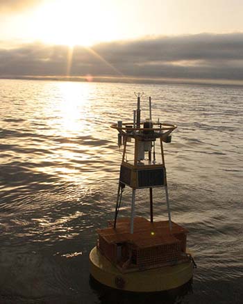
"Chá ba," a buoy off the coast of Washington, contributes better information about the ocean conditions that oysters can and cannot tolerate. Photo credit: NANOOS
In FY 2016, U.S. IOOS® and the National Weather Service completed work to integrate high-frequency radar-derived surface current data into the powerful data processing tool AWIPS-II (the Advanced Weather Interactive Processing System), giving Weather Forecast Offices (WFOs) in coastal areas new access to ocean data that directly impacts their service areas. IOOS operates the nation’s only high-frequency radar network, providing near-real time 2-D maps of ocean of surface currents speed and direction. This network supports U.S. Coast Guard search and rescue operations, NOAA response to oil spills, port navigation, tracking of harmful algal blooms, and now offers WFOs more insight into offshore and coastal storm movement, storm surge events, and wind movement.
 An official website of the United States government.
Here's how you know we're official.
An official website of the United States government.
Here's how you know we're official.