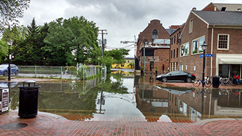
Nuisance Flooding in Alexandria, Virginia during the perigean spring tide in May, 2016
In 2016, The Center for Operational Oceanographic Products and Services (CO-OPS) provided the second ever outlook for nuisance flooding for the coming meteorological year. Nuisance flooding was also included as an indicator of climate change for the first time in the recent Environmental Protection Agency report, Climate Change Indicators in the United States. Nuisance flooding is recurrent flooding that takes place at high tide and can cause costly damage to infrastructure. Because of sea level rise, nuisance flooding in the United States has become a “sunny day” event – not necessarily linked to storms or heavy rain. The frequency of nuisance tidal flooding in many U.S. cities increased as predicted for the 2015 meteorological year, from May 2015 to April 2016, and in some cities, the days of nuisance flooding exceeded trends and broke records, especially in the southeastern U.S and Gulf Coast. The 2016 outlook expects the nuisance flooding trend to increase, but takes into account La Niña conditions that typically have less effect on tidal flood frequencies compared to El Niño. This outlook can help communities better understand local nuisance flooding frequencies and prepare for potential impacts. CO-OPS issued the first report on nuisance flooding in 2014, analyzing data from NOAA tide gauges where the water level exceeded the local threshold for minor flooding impacts established by the local Weather Forecasting Offices of the National Weather Services. CO-OPS worked with the National Centers for Environmental Information to issue the Nuisance Flooding outlook.
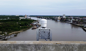
New air gap sensor on the Talmadge Memorial Bridge in Savannah, GA will help ships navigate safely into and out of port
In 2016, the Physical Oceanographic Real Time System (PORTSⓇ) held its 25th anniversary and added three new systems, for a total of 28 PORTSⓇ. New systems were added in Savannah, Georgia; Cape Cod, Massachusetts and on the Cuyahoga River in Ohio. These systems provide real-time, accurate, and reliable observations helping mariners and port operators to navigate safely, stay on schedule, and maximize cargo loading. More than 60 of the Nation’s most economically critical seaports are served by PORTSⓇ. NOAA has partnered with industry and local maritime organizations, as well as other federal and state agencies, to install these systems based on the needs of local mariners and port operators.
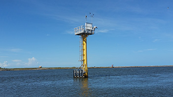
NWLON station specially reinforced to withstand hurricanes and other major storm events. Reinforced stations are better able to keep functioning during these events, providing critical information on water levels and winds that aids emergency response organizations
The Center for Operational Oceanographic Products and Services (CO-OPS) added four new water level stations in the Gulf that are specially reinforced to withstand hurricanes and other major storm events. The reinforced stations are better able to keep functioning during these events, providing critical information on water levels, winds and other meteorological information that can aid emergency response organizations. This was made possible through CO-OPS’ partnership with the Army Corps of Engineers in Galveston, Texas.
In December, the Center for Operational Oceanographic Products and Services (CO-OPS) helped the public in California understand how El Niño was impacting the water levels on the coast. CO-OPS provided technical guidance and communication materials to explain how the coastal flooding being seen was associated with elevated sea level from El Niño. CO-OPS documented the highest measured tides at eight water level stations throughout California during the high water level event over Thanksgiving, and released outreach materials directed at partners to communicate the causes and impacts of these events. CO-OPS coordinated with the Office of Coastal Management, the National Weather Service Weather Forecast Office in Eureka, the California coastal management community, and the Governor's office to provide this support.
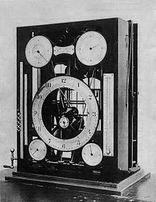
William Ferrel and Rollin Harris of the U.S. Coast and Geodetic Survey introduced the Maxima and Minima Tide Predictor, seen here, which began making predictions in 1885
The Center for Operational Oceanographic Products and Services (CO-OPS) completed the 2016 Tide Tables and Tidal Current Tables, which marks the 150th edition since NOAA began publishing them. These predictions are the cornerstone of the services NOAA provides the nation. They provide information for safe navigation for mariners, inform climate change research, help coastal communities understand when they may experience high or low water, and help commercial and recreational fishermen improve their catches. The Coast and Geodetic Survey, NOAA’s predecessor, published the first edition in December 1866 for the year 1867. The manuscripts have been shipped to publishers, and should be available in a few weeks.
 An official website of the United States government.
Here's how you know we're official.
An official website of the United States government.
Here's how you know we're official.