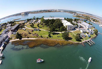
Aerial view of nature-based shoreline at NOAA laboratory on Pivers Island in Beaufort, North Carolina, in 2014. The shoreline, constructed from salt marsh plants and submerged oyster reef, was planted in 2000 and has successfully prevented erosion of the lawn behind the marsh
Hardened erosion control techniques, such as bulkheads and seawalls, often accelerate shoreline erosion and destroy the habitat of economically important fisheries and other wildlife. Nature-based shoreline stabilization options, like marsh grass and oyster reefs, offer erosion control while maintaining normal ecosystem functions.
In 2016, NCCOS co-authored the NOAA publication, Guidance for Considering the Use of Living Shorelines, which encourages nature-based shoreline stabilization techniques and highlights NOAA science, tools, and training that support such techniques. The publication has been shared with local, state, and federal coastal managers. NCCOS scientists quantified the amount of carbon stored in living shorelines, showing they can make a valuable contribution to carbon dioxide reduction strategies.
Also in 2016, NCCOS, along with other NOAA National Ocean Service offices, began a partnership with the U.S. Army Corps of Engineers to identify, prioritize, and implement projects that advance natural shoreline science and engineering practices. The group established a collaboration framework and produced a report that documents key data gaps and work priorities based on the inputs of over 40 cross-agency experts. The partnership is an extension of NOAA’s commitment to help coastal communities plan for and mitigate the effects of extreme weather events and changing ocean conditions.
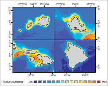
Modeled long-term relative abundance of Humpback whale around Main Hawaiian Islands in winter. Credit: NOAA and University of Hawaii at Manoa
NOAA continues to work closely with the Bureau of Ocean Energy Management (BOEM) to develop mapping products that support ocean energy development. Accurate maps and predictions of living marine resource distributions facilitate planning that reduces potential conflicts between human uses and sensitive marine ecosystem components needed for healthy and resilient coastal communities and economies.
In 2016, NCCOS scientists published an environmental assessment of the distribution of marine animals and benthic habitats around the main Hawaiian Islands, with special consideration given to species likely to interact with renewable energy infrastructure. These data will serve as foundational material for BOEM’s renewable energy leasing process and help identify potential issues for future National Environmental Policy Act (NEPA) analysis as Hawaii strives to generate 100 percent of its electricity from renewable energy sources by 2045.
Also in 2016, NCCOS and BOEM published an ecological study of the seafloor in a proposed offshore wind energy area off the coast of North Carolina. BOEM used these findings to modify the size and boundaries of the original area of interest to minimize possible impacts to sensitive reef and fishery habitats.
Offshore aquaculture is a promising new frontier for U.S seafood production. However, the growth of this industry has been constrained by concerns about negative environmental effects of improperly sited farms. In response, NCCOS and NOAA’s Office of Coastal Management partnered to develop a new, offshore aquaculture planning tool, CanVis. This seascape visualization tool contains an image library of aquaculture gear, vessels, buoys, and other infrastructure that can be used to simulate the changes that result from aquaculture development. Coastal managers and developers in Hawaii, California, and Washington are currently using this tool to visualize and plan offshore aquaculture projects.
In 2016, NCCOS demonstrated that oyster aquaculture can improve water quality as well as meet the demand for seafood. Oysters are filter feeders that remove nutrients from the water. Working with partners, we combined models on shellfish growth and nitrogen removal to determine the nitrogen removal potential of Long Island Sound’s existing and potential oyster aquaculture industry. Using economic analysis to determine the value of the ecosystem service provided by the oyster aquaculture industry, we found that both the cost and removal efficiency of nitrogen through shellfish aquaculture compare favorably to removal by existing agricultural and stormwater Best Management Practices. Also in 2016, NCCOS initiated similar projects in the Chesapeake Bay and Oyster Bay, Florida.
Scientists at the Sitka Tribe of Alaska Environmental Regulatory Laboratory use NCCOS-developed assay to detect paralytic shellfish toxins
NCCOS continues to improve the nation’s ability to forecast, detect, and mitigate the impacts of harmful algal blooms (HABs). In 2016, we identified the most pressing science needs in the Harmful Algal Blooms and Hypoxia Comprehensive Research Plan and Action Strategy, an interagency report co-authored by NCCOS and delivered to Congress.
NCCOS and its partners deliver HAB forecasts for Lake Erie, the Gulf of Maine, and the Gulf of Mexico. This year, the team improved the early season projections for Lake Erie (first tried in 2015) by adding a Maumee River flow forecast model from the National Weather Service. This model substantially reduced the uncertainty of those projections, which began almost two months prior to the final seasonal forecast. We also established an initial operating capability at NOAA’s Center for Operational Oceanographic Products and Services for production of the twice-weekly Lake Erie HAB bulletin. Final operating capability will be established next year.
In Alaska, NCCOS scientists trained staff at the Sitka Tribe of Alaska Environmental Regulatory Laboratory on the extraction and detection of paralytic shellfish toxins. The NCCOS-developed assay taught is a new method recently accepted by the Interstate Shellfish Sanitation Conference that can help secure the food supply against these potent algal-based toxins.
Vulnerability assessments consider a broad range of ecological, social, economic and cultural components, and examine how these components might be affected by specific climate change scenarios. These assessments can give coastal communities the information needed to address climate-related hazards, such as storm surge and sea level rise, and to identify adaptation strategies.
In 2016, social science researchers at NCCOS completed a vulnerability assessment for Talbot County and the Town of Oxford, Maryland in the Chesapeake Bay region. The team examined both environmental and social vulnerability using data collected on population demographics, economic characteristics, distribution of natural resources, and features of commercial and residential structures. These vulnerabilities were investigated alongside various flood hazard risks, including stormwater flooding, storm surge, and sea level rise. The results of the assessment will be used by the community to inform adaptation planning and corresponding management actions.
Following the success of this first vulnerability assessment, the researchers have already begun work on the next study area: the Choptank River Habitat Focus Area, which spans four counties in Maryland and one in Delaware.
 An official website of the United States government.
Here's how you know we're official.
An official website of the United States government.
Here's how you know we're official.