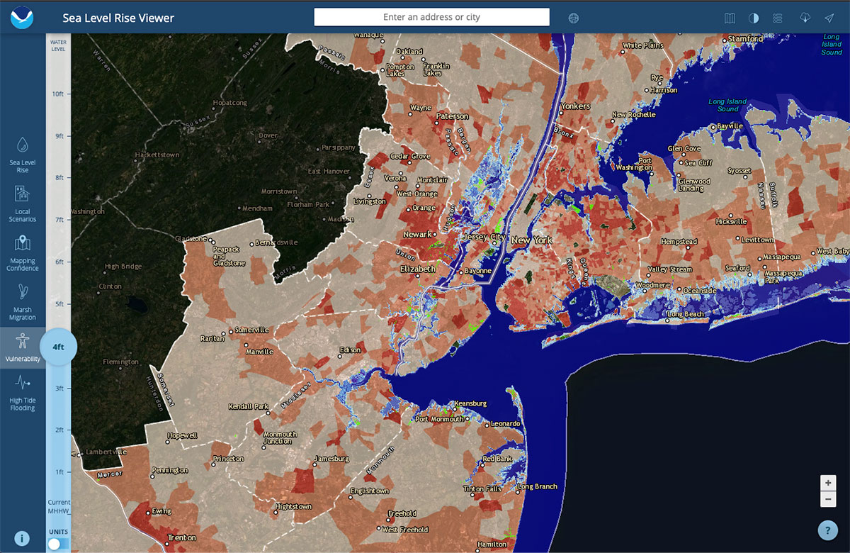
Geographic information systems (GIS) are mapping tools used to integrate, store, edit, analyze, share, and display geographic information. NOS provides a variety of GIS data products to the coastal management community. Pictured above is the Sea Level Rise Viewer that uses local elevation data and visualization software to allow users to see how one to ten feet of sea level rise might affect their coastal communities.
Is this area vulnerable to erosion and therefore not a safe place to build a road? What would be the most effective way to restore this coastal marsh back to its original state? How can we grow our community without hurting water quality?
Balancing the use of resources in coastal areas with their protection requires good tools and information to make good decisions. To help state and local coastal resource managers make the best decisions, the National Ocean Service (NOS) provides training, data and information, management strategies, and technology.
Going coastal
Live near the coast? You aren't alone. Over half of all Americans live in coastal states. And each year, more people flock to our nation's coasts. With them comes more development — new homes, businesses, roads. While this growth enriches the economy, it also places pressure on the environment, potentially diminishing the aesthetic and economic value of living in a coastal area. NOS works to deliver tools to help balance the health of our coasts with the health of our economy.
Science to tools
At NOS, we transform science into practical, innovative tools. For example, the Science Collaborative is a program that puts science conducted at National Estuarine Research Reserves to work in coastal communities. Administered by the University of Michigan, the program supports reserve-led projects that bring together scientists, decision-makers, and educators to address coastal pollution and habitat degradation in the face of climate change.
Making it social
NOS addresses the “people” part of coastal management by developing and applying social science research, tools, data, and learning opportunities. Visit the Economics: National Ocean Watch Explorer for easy access to economic data at state and county levels and learn about basic but important economic principles through our economic video series.
Educating new leaders
The students of today will be the leaders of tomorrow. NOS invests in training these future leaders through a number of fellowship programs. The programs allow students and post graduates to work for state coastal management programs, gain professional experience in coastal and coral reef resources management, receive professional mentorship and training, and more.
A view from above
Remote sensing involves the use of satellites, aircraft, and other devices to gather information about land and water. NOS provides remote sensing data, including that of land cover, topography, and ocean-floor habitat, to state coastal programs. NOS scientists also use remotely sensed data to develop other tools and services, such as coastal maps, disaster response, harmful algal bloom analysis, coastal ecosystem monitoring, and nautical charts.
Map it out
Geographic information systems (GIS) are mapping tools used to integrate, store, edit, analyze, share, and display geographic information. NOS provides a variety of GIS data products to the coastal management community, including digital shoreline data, hurricane information, and watershed mapping projects. Other GIS tools include Land Cover Atlas, to view trends in habitat loss or development, which help inform management decisions; Environmental Sensitivity Index maps, which help assess contamination risk; and data used to characterize coastal zone habitats.
Smart growth
Bounded by water, coastal communities must make use of limited land while protecting natural resources from the effects of population growth and development. NOS, in partnership with the Environmental Protection Agency, the International City/County Management Association, and Rhode Island Sea Grant, developed a guide and website to help officials make coastal “smart growth” decisions that balance use and enjoyment of coastal areas with conservation.
Did you know?
The Digital Coast is a cost-effective resource for coastal communities. Through the Digital Coast, users can find the information they need to explore the implications of sea level rise, conduct risk and vulnerability assessments, develop community green infrastructure plans, and much more.
 An official website of the United States government.
Social