Coastal intelligence…two words that have definitions all their own, but when linked together take on a broader meaning. This phrase specifically refers to the ability of public and private decision-makers along the coast to make the best choices for their communities. The National Ocean Service and partners provide a wide variety of coastal intelligence capabilities to help in this effort—ranging from nautical charts, to ecoforecasting, to geodesy, to socioeconomic data. Why? Because good decisions today protect lives and property tomorrow.
The Big Picture
Coastal intelligence provides timely, actionable information developed from reliable and authoritative science to provide insight into present and future conditions in the coastal zone. People in the maritime community rely on coastal intelligence for a range of decisions, from how much cargo to load on a ship to choosing the most efficient and safest route between two waterborne points. Coastal intelligence is just as important for coastal populations and community coastal resilience. NOS’s capabilities help
communities make informed decisions about sustainable use of the environment and think through how future
choices, climate change, and coastal development will impact them.
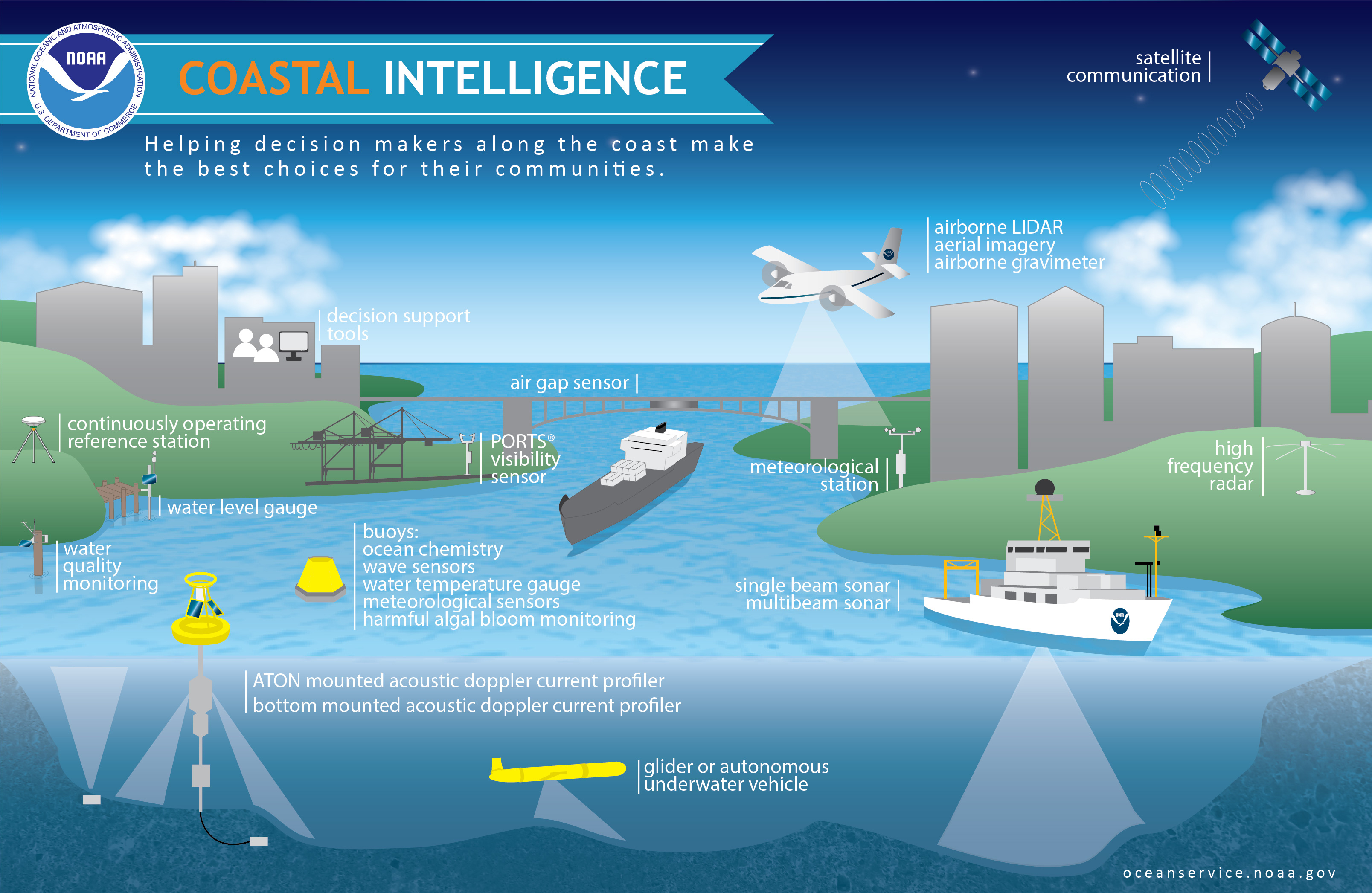
Layers of Preparation
Our goal is to provide information to help communities create the best outcome for our coasts in light of hazards such as climate change and weather events. We deliver data from observations and surveys, layered upon prediction models and topography/bathymetry maps, coupled with aerial and satellite imagery and continuous weather conditions. These layers of information describe and inform decisions that affect public safety, coastal community resilience, our economy, and sustainable use of the environment.
Science to Solutions
Investments in improved response to coastal environmental hazards help to ensure that coastal citizens, planners, and emergency managers have the reliable information they need to make the best environmental decisions for their communities. Services such as aerial imagery and models for storm surge, products and tools like Digital Coast, Hurricane Tracker, and maps for sea level rise are all examples of NOAA tools and services that assist coastal managers with the decisions they need to make before, during, and after environmental events.
Communication is Key
Coastal intelligence comes down to a clear understanding and accurate communication of risks. Promoting resilience to coastal hazards and climate change, building a Weather-Ready Nation, improving the livability of coastal communities, and ensuring safe and efficient navigation: these are all ways that NOAA and partners are working to improve coastal intelligence.
Coastal intelligence refers to information that is used by governments, businesses, and citizens to make decisions that support healthy ecosystems, strong economies, and resilient communities along our coasts. NOS and partners support this decision-making process by translating science—coastal and ocean observations, data, and research—into information that people can use.
 An official website of the United States government.
Here's how you know we're official.
An official website of the United States government.
Here's how you know we're official.