Sargassum is a type of floating brown algae that provides food, protection, and habitat for many marine species. While Sargassum plays an important role in the health and biodiversity of open ocean ecosystems, it can also be harmful in certain situations when large masses are carried to shore by winds and currents. NOAA manages many fish species that depend upon floating rafts of Sargassum for food and shelter that are out at sea in U.S. waters. NOAA and partners provide tracking and forecasting tools to let people know when and where Sargassum masses are likely to come ashore. Once Sargassum washes on land, NOAA experts provide support and scientific expertise to help affected communities. Ongoing NOAA research helps us better understand and manage the public health, social, and economic issues posed by Sargassum.
1
The Great Atlantic Sargassum Belt
Historically, the majority of Sargassum was located in the Sargasso Sea in the western North Atlantic. In 2011, the geographic range of Sargassum expanded. A newly established population, driven by shifting wind patterns, is now thriving in the open ocean. This region is called the "Great Atlantic Sargassum Belt." Massive amounts of Sargassum from this area are transported west into the Caribbean Sea, Gulf of America, and tropical South Atlantic via ocean currents.
2
Essential Fish Habitat and Critical Habitat
Free-floating, offshore Sargassum provides habitat, food resources, protection, and breeding grounds for hundreds of marine species. This includes commercially important fisheries species such as gray triggerfish, amberjack, and mahi mahi that feed on the smaller marine life present in Sargassum rafts. In the South Atlantic, Gulf of America, and the Caribbean, NOAA designates areas of Sargassum as Essential Fish Habitat. Juvenile sea turtles and sea birds also use Sargassum for food and shelter. In the North Atlantic and Gulf of America, Sargassum is one of the essential features of designated critical habitat for loggerhead sea turtles and proposed critical habitat for green sea turtles under the Endangered Species Act (ESA).
Federal agencies that authorize, fund, or carry out Sargassum harvest activities that may impact species listed as threatened or endangered under the ESA must consult under Section 7 of the Act to ensure that their activities will not jeopardize the continued existence of ESA-listed species or destroy or adversely modify critical habitat. Private entities should also consider if their harvest activities may impact ESA-listed species and are encouraged to seek an Incidental Take Permit under Section 10 if interactions cannot be avoided.
3
On Shore: Sargassum Inundation Events
Sargassum inundation events occur when masses of this algae are carried to shore by winds and currents. These events are a type of harmful algal bloom that can adversely impact coastal ecosystems, tourism, and public health. Massive amounts of Sargassum can form brown tides nearshore, smothering fauna and flora — including coral reefs. Sargassum masses may also clog water intake pipes used in critical infrastructure (for example, in desalination plants that produce drinking water). Sargassum also contains high levels of arsenic and other heavy metals, organic contaminants, and marine debris. Sargassum decomposing on the beach produces hydrogen sulfide, a gas that smells like rotten eggs, which can cause respiratory irritation. Cleanup options are limited and costly.
What is NOAA's role?
Tracking and Forecasting
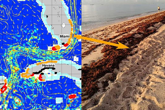
NOAA and partners monitor and track Sargassum, providing online forecasts and near real-time conditions.
- In partnership with the University of South Florida, NOAA uses its satellites to generate a daily risk map that shows where Sargassum is likely to wash ashore in coastal areas of the U.S., Caribbean, and Central America.
- In partnership with the Caribbean Coastal Ocean Observing System, NOAA produces short- and long-term forecasts, a seven-day outlook, and the latest satellite imagery of Sargassum-affected regions in the Atlantic and Caribbean, available via the Sargassum Tracker. Ongoing research continues to improve these products.
Image credit: Marine Macroalgae Research Lab - Florida International University
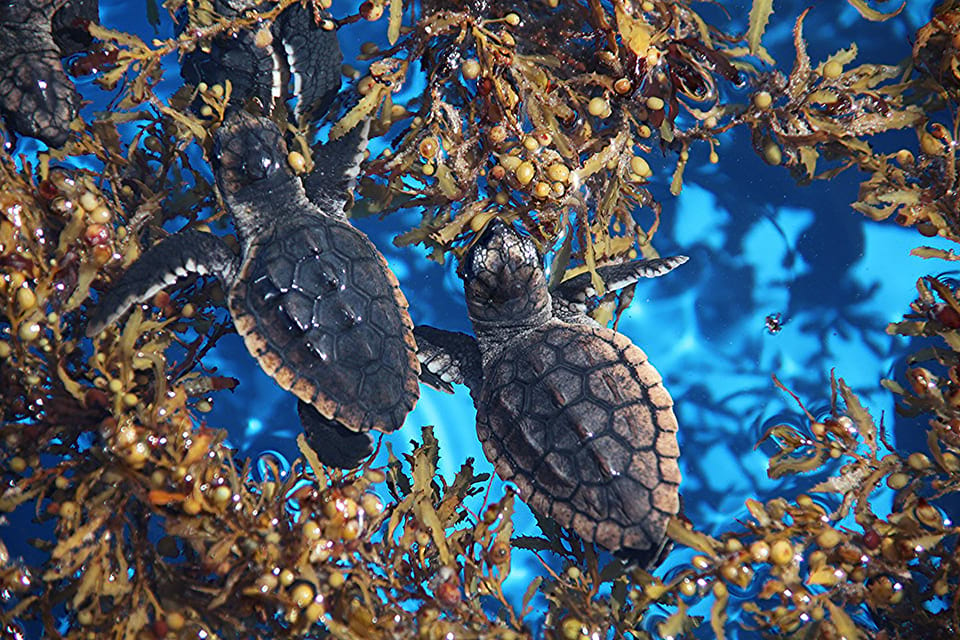
Managing Habitat
NOAA designates Sargassum as Essential Fish Habitat for several species, including gray triggerfish, amberjacks, and mahi mahi. These fisheries are managed by regional fishery management councils in the South Atlantic, Gulf of America, and the Caribbean. While Essential Fish Habitat status itself does not restrict harvest, NOAA Fisheries consultation is required for any federal activities in these areas that may impact the habitat. In a separate management plan, NOAA Fisheries prohibits harvest of Sargassum in all U.S. federal waters (between 3 miles to 200 nautical miles) south of the North Carolina/South Carolina state boundary. Sargassum is also an essential feature of designated critical habitat for loggerhead sea turtles and proposed critical habitat for green sea turtles in certain areas of the North Atlantic and Gulf of America. Federal agencies are required to ensure that any action they authorize, fund, or carry out is not likely to destroy or adversely modify critical habitat under the ESA.
Image credit: Florida Fish and Wildlife
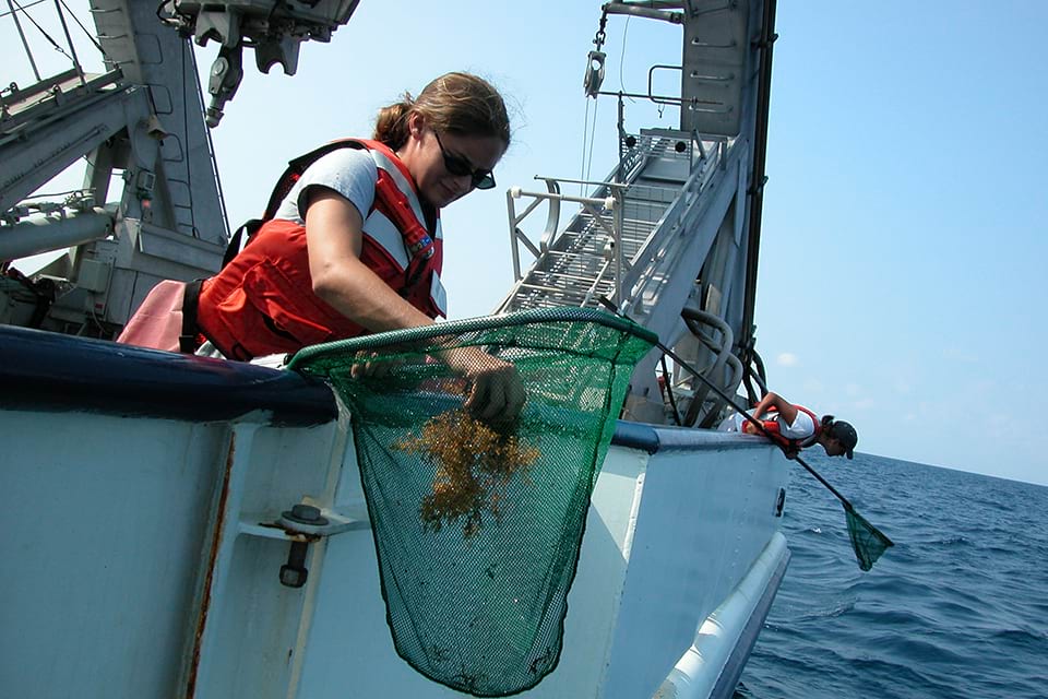
Conducting Research
When excessive amounts of Sargassum reach the shore, it is referred to as a "Sargassum inundation event." Such events can become harmful algal blooms — when algae grows out of control or produces toxins that harm people, fish, shellfish, marine mammals, and birds. NOAA coordinates cross-agency actions during such events, and funds research to understand and manage harmful algal blooms, which includes improving detection and forecasting technologies. NOAA also engages with people affected by Sargassum to aid in the design of more accurate and timely warnings, and is studying the social and economic impacts of Sargassum beaching.
Image credit: Life on the Edge 2004
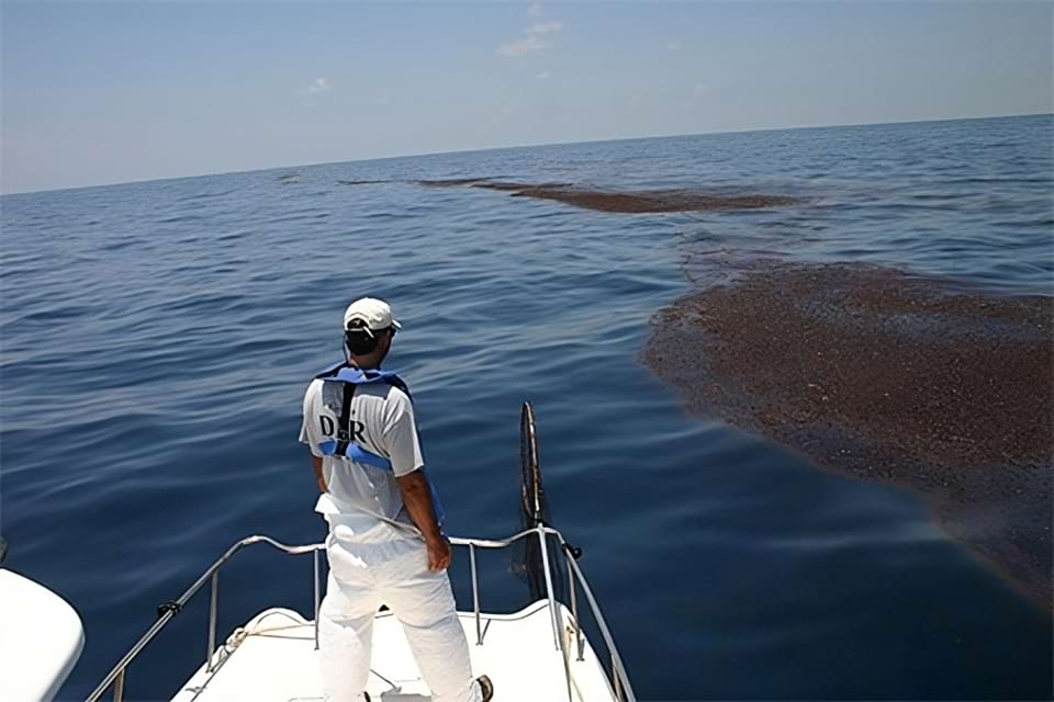
Helping with Response
NOAA may provide scientific support for inundation events that receive a federal emergency declaration, such as the 2022 declared emergency in the U.S. Virgin Islands. Experts are also studying and preparing for responding to oil and chemical spills that involve Sargassum. NOAA also provides expertise and training to communities to address coastal issues with the goal to increase the resilience of the nation's coastal zone, and provides support for data collection, training, technical assistance, and other harmful algal bloom response actions.
Image credit: NOAA
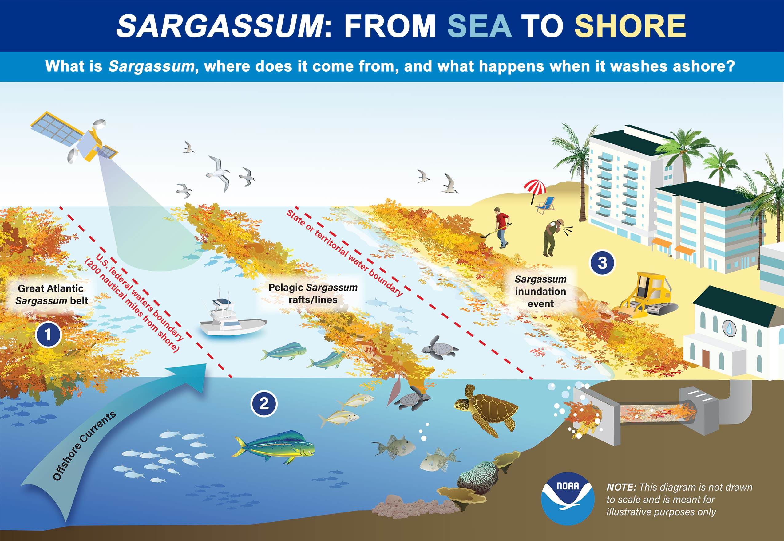
Infographic Description
The top two lines of this infographic say "Sargassum: from sea to shore" and "What is Sargassum, where does it come from, and what happens when it washes ashore?" Underneath this text, there is an illustration that shows Sargassum, a brown and orange-tinted algae, in the open ocean on the far left, within the U.S. federal waters in the middle, and a coastal Sargassum inundation event (beaching) on the right. The illustration is three-dimensional, showing the surface of the ocean and land, as well as a cross section of the ocean below. The bottom right of this graphic shows the NOAA logo and a note that says "This diagram is not drawn to scale and is meant for illustrative purposes only." The following are descriptions of each of the three sections of this illustration:
- The left section of the illustration shows an aggregation of Sargassum, representing the Great Atlantic Sargassum belt in the open ocean. This section is labeled with the number "1" in a blue circle, which corresponds to the first bullet of text in this article: "Out at Sea: The Great Atlantic Sargassum Belt." Underneath the image representing the Great Atlantic Sargassum Belt, the silhouette of small schools of fish are visible. Below this, there is a sweeping arrow rising up from under the ocean, which is labeled "Offshore Currents." This represents how currents, along with winds, push Sargassum from the open ocean towards land.
- The middle section of the illustration shows pelagic Sargassum floating in what are called massess, rafts or lines. This section is labeled with the number "2" in a blue circle, which corresponds to the second bullet of text in this article: "Closer to Shore: Essential Fish Habitat." Sargassum is shown floating in between two red lines on the graphic: the first red line, on the left, designates the boundary of the U.S. federal waters, which is 200 nautical miles from the U.S. coastline; the second red line, on the right, indicates the starting point of U.S. state waters (three miles out from the U.S. coastline). In the ocean, below the Sargassum, many species of fish swim, including mahi mahi, triggerfish, and amberjacks. There is also a sea turtle and corals on the bottom of the ocean. On the surface, there is a fishing boat near the Sargassum. Above in the sky, there are sea birds. And above that, there is a satellite with a beam focused down on the ocean, representing how NOAA satellites are used to track and monitor movement of the Sargassum.
- The right section of the illustration is from the area (dashed red line) where U.S. state waters begin at three miles out all the way to the shore. This section is labeled with the number "3" in a blue circle, which corresponds to the third bullet of text in this article: "On Shore: Sargassum Inundation Events." In this portion of the graphic, the bulk of the Sargassum is shown washed up on shore, and there is some floating Sargassum nearshore representing a “brown tide.” On the beach where the Sargassum is washed up, there is text that says "Sargassum inundation event." There is a person with a shovel and a bulldozer on shore cleaning up the Sargassum. Another nearby worker who is engaged in cleaning up the Sargassum is coughing, indicating the public health concerns of this inundation event. In the forefront of the graphic, there is a desalination plant with a water intake pipe in the ocean, which is shown clogged by Sargassum. In the background, there is a hotel and an empty beach chair, representing how there are no tourists present due to the beaching of the Sargassum.
Resources
About Sargassum
Sargassum Forecasting
Preparing for and Responding to Sargassum Inundation Events
Coordinating Management Efforts and Response to Sargassum Inundation Events
Oil Spills and Pelagic Sargassum
On Sea Turtles, Seaweed, and Oil Spills
Policy and Management of Sargassum
 An official website of the United States government.
Social