Better models help communities improve their extreme-event responses
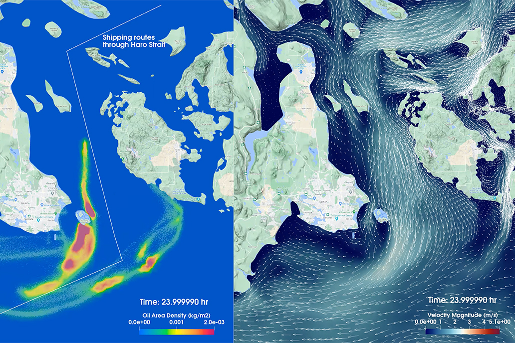
Users of NOS’s coastal, ocean, and Great Lakes models and information have a wide variety of needs for predictive information about our ocean and coasts. Meeting these needs demands a collection of models that are flexible, multipurpose, and tailorable to specific geographic or temporal scales. In this example, a model simulates the trajectory of a hypothetical oil spill and associated wind patterns in Haro Strait, Washington.
The National Ocean Service Modeling Advisory Board has released a five-year strategy to improve prediction of risks to coastal and Great Lakes communities facing the physical and economic threats posed by climate change. Under the NOS Modeling Strategy 2023–2028, NOS will work with partners across NOAA, other federal agencies, academia, industry, nonprofits, and local, state, and tribal governments to advance models that will meet the public’s need for reliable predictions of coastal conditions.
The multiyear modeling strategy builds on the NOS Modeling Vision that individuals and communities nationwide will be able to understand and use reliable, accurate, and accessible predictions of coastal conditions. Access to improved models means coastal communities can make more informed decisions to better protect lives and property in the face of immediate threats like flooding, hurricanes, toxic algal blooms, or chemical spills. Models can also help communities plan how they will protect existing infrastructure, design new infrastructure, and build coastal resilience with strategies that are appropriate for their regions.
These models, part of NOAA's Operational Forecast System, show typical hourly forecasts of different oceanographic conditions for the Chesapeake Bay. Similar hourly spatial animations for the next 48 hours are available online for other locations and are updated every six hours.
Models incorporate vast amounts of past and present water, atmospheric, and remote sensing data to reflect current conditions and to predict future environmental conditions. This data must be quality assessed before modelers can create simulations that are then analyzed and interpreted as ocean and coastal predictions. Models use a combination of scientific equations and historical observations to simulate environmental conditions. NOS models are now advancing to use near and real time observations (called data assimilation) to improve the accuracy of models in a rapidly changing world.
NOS modelers work with the external modeling community to develop, test, and transition models from the research stage to the operational stage. The NOS Modeling Strategy takes advantage of that structure and provides a vision and goals to further advance collaborations across the NOS offices and divisions that are either developing or operating models, or are users of NOS model data. This more holistic approach to meeting stakeholder needs will require more collaboration within NOS and with the broader modeling community.
Collaboration is a critical component of the NOS Modeling Strategy. NOS will sponsor community modeling workshops and seminars, and grow a community of practice dedicated to fostering partnerships within the coastal modeling community. NOS also will encourage businesses and other entities to use its models in products and services that generate economic value for the blue economy and that address societal challenges.
Did you know?
NOAA has been a leader in the climate modeling world since the late 1960s. At the time, the scientific community was seeking ways to understand how interactions between the ocean and the atmosphere influence climate. So Drs. Syukuro Manabe and Kirk Bryan from NOAA’s Geophysical Fluid Dynamics Laboratory in Princeton, New Jersey, gave the community what it needed when they developed the first-of-its-kind general circulation model. This pioneering model was used in the 1970s to test the idea of global warming.
 An official website of the United States government.

Social