IOOS Ocean Technology Transition Program
Six new multi-year grants announced for 2020.
 An official website of the United States government.
Here's how you know we're official.
A .gov website belongs to an official government organization in the United States.
A small lock or https:// means you’ve safely connected to a .gov website. Share sensitive information only on official, secure websites.
Once the domain of ships and researchers at sea, new technologies are offering us ways to explore more of our ocean and coasts more often at lower cost. The U.S. Integrated Ocean Observing System's (IOOS®) Ocean Technology Transition program, an ongoing multi-year cooperative grant initiative, is one effort working to meet the need for new technology and novel approaches to address ocean observing needs.
OTT looks for developing ocean, coastal, and Great Lakes observing, product development, and data management technologies for which there is a known need and steps in to accelerate its transition to operations. These technologies include hardware and software platforms, sensors, and data management aimed at improving available ocean information to support decision making for the coastal ocean, and Great Lakes’ environments.
For 2020, IOOS, in conjunction with the National Oceanographic Partnership Program (NOPP), sought projects focused on regional coastal ocean observing systems and advancing data management and cyberinfrastructure for observations. Here are the grants awarded in 2020.
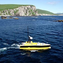
This project will operationalize water profiling capabilities on the L3Harris C-Worker 5 autonomous surface vehicles (ASVs) for deployment in the Gulf of Mexico. These small vehicles will increase the number of profiles that researchers gather in the summer, assisting NOAA’s annual requirement to map the mid-summer hypoxic zone.
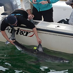
This project will help develop and test a new conductivity-, temperature-, and depth-logging animal-borne electronic tag. Deployed on blue and white sharks in the Mid-Atlantic Bight, data from these tags will increase the amount of available ocean data for weather forecasting.This project will develop a new conductivity-, temperature-, and depth-logging animal tag.
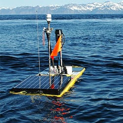
This project will further development of a carbon dioxide sensor small enough to fit on autonomous surface vehicles (ASVs) and hardy enough to withstand the harsh conditions these vehicles can encounter. Carbon dioxide monitoring is mainly conducted by ships of opportunity which limits where and when sensors can be deployed. With added ASV capability, we could monitor more of the ocean more often.
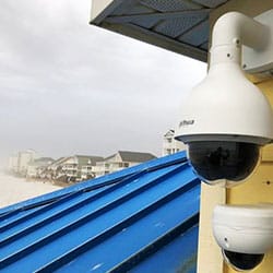
This grant will transition the Web Camera Application Testbed (WebCAT) to a new, sustained network called Webcams for Coastal Observations and Operational Support (WebCOOS). Camera observations provide important visual data to understand resource use, validate run up models, and count wildlife.
This project will operationalize ongoing work to gather water samples for harmful algal bloom monitoring using autonomous surface vehicles. Sampling with the Ocean Aero Triton vehicle allows researchers to gather samples more frequently and in more locations than current methods permit. This diverse sampling capability will improve on the ability to detect and respond to HABs.
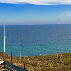
This project will develop, test, and implement software to mitigate the interference of offshore wind turbines on oceanographic high-frequency radar (HFR) observations of surface currents. By preventing blind spots in the HFR national coverage due to this interference, this software will allow IOOS-sponsored surface current mapping and offshore wind energy installations to operate effectively alongside one another.
Social