U.S. flag An official website of the United States government.
Here's how you know we're official.

dot gov icon Official websites use .gov

A .gov website belongs to an official government organization in the United States.

https icon Secure websites use HTTPS

A small lock or https:// means you’ve safely connected to a .gov website. Share sensitive information only on official, secure websites.

National Oceanic and Atmospheric Administration logo National Ocean Service National Oceanic and Atmospheric Administration
  • Home
  • Ocean Facts
  • Topics
    Explore All Topics Arctic Careers Economy Ecosystems Geodesy Hazards International Navigation Observations Ocean Recreation Sea Level Rise Story Maps Tools
  • Education
  • News
  • Podcasts
  • Video
  • Images
  • About Us
  1. Home
  2. Topics
  3. Geodesy
  4. A Tale of Three Datums

A Tale of Three Datums

Keeping up with an ever-changing Earth.

  • National Tidal Datum Epoch
  • International Great Lakes Datum
  • Gravity for the Redefinition of the Vertical Datum

NOAA is currently working on three major updates to vertical datums. They’re used for everything from nautical charts and flood maps to infrastructure planning. A datum is a reference system that starts at an agreed data point. You’re probably familiar with at least one horizontal datum — latitude and longitude. If you’ve been to a mountaintop and seen a sign with the distance above sea level, you’re also familiar with vertical datums, which measure heights. Here’s a rundown on what we’re updating and why.

1

National Tidal Datum Epoch

The  NOAA San Francisco Tide Station, in operation for more than 150 years.

The rise and fall of the tides play an important role in the natural world and can have a marked effect on maritime-related activities. The NOAA San Francisco Tide Station, shown here, has been in operation for more than 150 years.
What is the National Tidal Datum Epoch?

  • A set of reference points for water levels at different stages of the tide, such as mean high water and mean sea level.
  • NOAA collects data on a 19-year cycle (called an epoch) for locations on U.S. coasts and averages the data to create these reference points.
  • How high the water goes at high tide is important information for flood maps and planning projects on shore, like where to put a road or housing development.
  • How low the water goes at low tide is critical to ensure ships don’t run aground.
  • Scientists also use the data to track sea level rise, to track long-term oceanographic trends, and to predict the effects of severe weather.

What are we doing?

  • Every 15-20 years (an epoch), we take the data from 200+ National Water Level Observation Network stations on the U.S. coasts and calculate new averages.

Why does it need to be updated?

  • Water levels don’t stay the same. Sea level rise continues to accelerate.
  • The earth’s crust is also rising and sinking in different areas at different rates. The land is rising in parts of the West Coast and Alaska. It’s sinking on the East and Gulf coasts.
  • We have to update the data regularly to keep it accurate.

2

International Great Lakes Datum

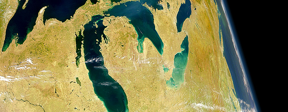
A NASA image of the Great Lakes from space

While the Great Lakes do not have tides, water levels in the lakes are ever-changing for a surprising reason: the land is still rebounding from ice-age glaciers.
What is the International Great Lakes Datum? How is it different from National Tidal Datum Epoch (NTDE)?

  • Like the NTDE, this datum is a set of reference points for water level heights. Unlike the NTDE, each location only has one water level measurement — mean water level. The Great Lakes are considered non-tidal, so there are no high or low tide levels.
  • This data comes from the Great Lakes and connected waterways, like the St. Lawrence River, that span locations in the United States and Canada.
  • This datum is used for nautical charts, flood maps, and shoreline planning, just like the NTDE. It’s also very important for dredging and other projects that maintain the important shipping lanes in the Great Lakes.

What are we doing?

  • Using permanent and seasonal water level stations, NOAA oceanographers and Canadian counterparts are collecting water level data and will calculate new averages.

Why does it need to be updated?

  • The land in this area is also shifting. During the last ice age, the area was covered by glaciers, and the weight of the glaciers caused the land to sink. Though the glaciers are long gone, the earth’s crust is still bouncing back from this extra weight, particularly in the northern part of the Great Lakes region. The shifting land changes the water levels.
  • We have to update the data every 25-30 years to keep it accurate.

3

Gravity for the Redefinition of the Vertical Datum (GRAV-D)

The  NOAA San Francisco Tide Station, in operation for more than 150 years.

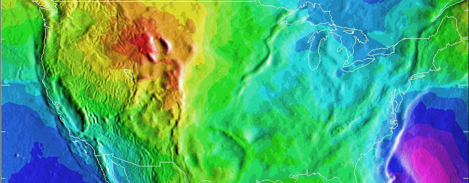
Scientists at the National Geodetic Survey maintain a nationwide coordinate system that defines latitude, longitude, height, scale, gravity, orientation, and the national shoreline throughout the United States. This geodetic reference system ensures that those who need accurate positioning information are all working from the same reference points. The height component of this nationwide system is called the North American vertical datum. This image is a depiction of the U.S. geoid, a model roughly representing global mean sea level that is used to measure precise surface elevations. Areas in yellow and orange have a slightly stronger gravity field as a result of the Rocky Mountains.

What is the geodetic vertical datum?

  • The datum is a set of height measurements for the U.S. and its territories, generally referred to as the height above sea level.
  • While the national tidal and international Great Lakes datums measure the height of water, this datum measures the height of the land.
  • The Gravity for the Redefinition of the American Vertical Datum (GRAV-D) project is using satellite data and gravity measurements to calculate more precise vertical heights. The resulting updated datum will replace an older datum, NAVD88, which was made with old-fashioned leveling and surveying techniques.

What are we doing?

  • We are flying across the U.S. and territories and collecting gravity measurements from the air.
  • We have to measure gravity because it’s not uniform. Local topography and rock density create subtle changes in local gravity.
  • Using gravity allows us to determine where sea level would be, even in areas far from the coast. This can tell us where water will flow.
  • The gravity measurements will be combined with satellite data and data collected on the ground to create accurate height measurements across the U.S. and territories.

Why does it need to be updated?

  • The old datum, NAVD88, is no longer as accurate as it should be. The old leveling techniques used to create the datum can cause inaccuracies and make it difficult to update or re-check data as time passes.
  • NAVD88 is particularly inadequate in places where ground surveying is difficult or impossible — like parts of Alaska.
  • With GRAV-D, we will have more accurate height data for more places in the United States and territories.
  • Using gravity data instead of leveling and surveying gives us information on where water will flow. This is critical for floodplain maps, planning building projects and evacuation routes, and can even help cut down on pollution from fertilizer and pesticide runoff.
  • Using gravity measurements and satellite data also makes it easier to update the datum as land shifts, and to track those changes over time.
More Information

Search Our Stories
Get Social
Social

  • Twitter Logo
  • Facebook Logo
  • Instagram Logo
  • Youtube Logo
  • LinkedIn Logo
Last updated:
06/16/24

Author: NOAA

How to cite this article

Contact Us

scroll to top arrow icon
Feedback
  • Contact Us
  • Report an error
Social
  • X Logo
  • Facebook Logo
  • Instagram Logo
  • Youtube Logo
  • LinkedIn Logo
NOAA Logo

Science. Service.
Stewardship.

About NOS
  • About Us
  • NOS Program Offices
  • Media Inquiries
  • Site Index
  • Disclaimer
More Resources
  • Freedom of Information Act
  • Accessibility
  • Information Quality
  • Privacy Policy
  • USA.gov
  • Department of Commerce
  • National Oceanic and Atmospheric Administration (NOAA)
  • National Ocean Service