The National Spatial Reference System (NSRS) is a consistent coordinate system that defines latitude, longitude, height, scale, gravity, and orientation throughout the United States
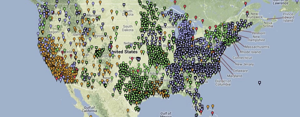
NOAA's National Geodetic Survey defines and manages the National Spatial Reference System (NSRS) - a consistent coordinate system that defines latitude, longitude, height, scale, gravity, and orientation throughout the United States. In addition to a network of continuously operating reference stations (CORS) supporting three-dimensional positioning activities (shown here), the NSRS includes a network of permanently marked points; a consistent, accurate, and up-to-date national shoreline; and a set of accurate models describing dynamic, geophysical processes that affect spatial measurements.
NOAA's National Geodetic Survey (NGS) defines and maintains the NSRS. The NSRS includes a network of permanently marked points; a consistent, accurate, and up-to-date national shoreline; a network of Continuously Operating Reference Stations (CORS) which supports three-dimensional positioning activities; and a set of accurate models describing dynamic, geophysical processes that affect spatial measurements.
For over 200 years, NGS and its predecessor agencies have collaborated with surveyors in both the public and private sectors to place hundreds of thousands of survey marks throughout the United States, determining positional information for each mark. Each survey mark is published with accurate horizontal and/or vertical information such as latitude, longitude, and/or height. Typically, a mark is a brass, bronze, or aluminum disk, but it might also be a deeply driven rod or prominent object like a water tower or church spire. Increasingly, the continuously operating global positioning system receivers of CORS stations are used as reference stations as well.
This collection of points (over 1,500,000 of them) forms a network that is used to accurately position other points of interest. Surveyors and others use the NSRS throughout the country to ensure that their positional coordinates are compatible with those determined by others. In this way, when they create maps; mark off property boundaries; and plan, design, and build roads, bridges, and other structures, everything matches up.
 An official website of the United States government.
Social