Shore-based Current Meters
Currents Tutorial
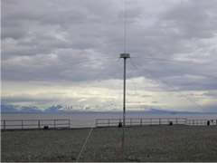
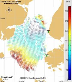
Shore-based current meters employ radio antennas and high frequency (HF) Radio Detecting and Ranging systems (radar) to measure surface ocean currents. Following the same premise of the ADCP, these shore-based instruments use the Doppler effect to determine when currents are moving toward or away from the shore. If a wind-driven current is moving toward the shore, the return signal is at a high frequency. If the wind-driven current is moving away from shore, the return signal is at a low frequency. Scientists also use these measurements to determine the velocity of the current. When two or more radar antennas are used, a scientist can calculate an entire field of surface current velocities for thousands of points. Using this data, the scientist can produce a “map” of surface currents for a large coastal area.
Currents Lessons
- Welcome
- Tidal Currents 1
- Tidal Currents 2
- Waves
- Longshore Currents
- Rip Currents
- Upwelling
- The Coriolis Effect
- Surface Ocean Currents
- Boundary Currents
- The Ekman Spiral
- Thermohaline Circulation
- The Global Conveyor Belt
- Effects of Climate Change
- Age of Exploration
- What is a "knot"?
- Shallow Water Drifter
- Deep Ocean Drifter
- Current Profiler
- Shore-based Current Meters
- How Currents Affect Our Lives?
- References
- Roadmap to Resources
- Subject Review