Ocean Gliders: How NOAA uses autonomous technology to help predict hurricane intensity.
NOAA Ocean Podcast: Episode 26
Ocean gliders are autonomous underwater vehicles used to collect valuable ocean data, including information about hurricanes. In this podcast, we uncover the technology behind hurricane gliders, and what they can do for us to prepare us for hurricanes.
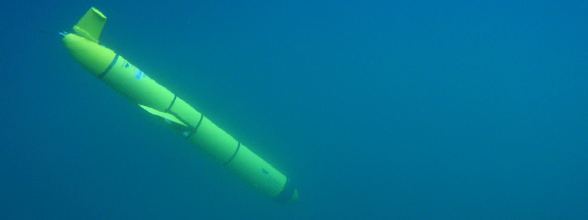
An autonomous underwater glider collects ocean data. Glider data, as well as data from other ocean observing systems showing lower concentrations of salt in surface seawater, can be a clue that this lighter water may form a warm cap that prevents cool water from welling up to the surface. This warm cap can then fuel a hurricane’s strength. Glider data also helps scientists better predict if the cooler water lying just below the warm surface waters is likely to rise and mix with the surface waters and weaken hurricane strength.
Transcript
HOST: You’re listening to the NOAA Ocean Podcast, I’m Megan Forbes. In this episode we’re going to be talking about Ocean Gliders and how they help scientists predict and forecast hurricane intensity. I sat down with Ben LaCour, the Executive Officer for the U.S. Integrated Ocean Observing System (IOOS®) Program at NOAA, and asked him all about it. Give a listen.
HOST: I’ve welcomed Ben LaCour here with me to talk about exactly what hurricane gliders are, and what they can do for us in terms of the coming season and to prepare us for hurricanes. So, welcome, Ben! Thanks for joining me today!
BEN LACOUR: So let me start with a little bit about what gliders are, maybe. Gliders are a type of technology that can operate on their own for multiple months under the ocean, collecting data and information about the ocean. So they’ve been used for probably close to 15 or 20 years by researchers across the world, but primarily a lot of the technology was developed here in the United States. For the last few years, there has been some researchers that have been using gliders to basically monitor and see what happens when a hurricane passes over - see what the effects and changes are in the ocean. Part of that, the data that’s collected, can be used to help improve hurricane forecasts. So when you hear the term “hurricane picket lines” or “hurricane gliders”, really its talking about using this type of autonomous technology to better understand, specifically, hurricane intensity, and how the ocean impacts a hurricane’s intensity - and through that research, it will help improve hurricane intensity forecasts.
HOST: How do you set something to go for months without anybody driving it or moving it? Is there someone always checking it? How does that work...what is the science behind that?
BEN LACOUR: Yeah, good question. So the way that the technology works...there’s somebody at a computer terminal on land somewhere that basically checks on the glider and sees how it’s doing. They can deliver commands to the glider and can also receive data from the glider in real-time or near real-time through satellites. The way the glider works is it makes small changes in its buoyancy to either sink or float, and one of the things that all underwater gliders have is wings - just like gliders in the air. So, as this thing starts to sink or float, the wings give it propulsion forward, that’s how it moves. It actually doesn’t have a motor or any type of engine, so to speak, as its primary means of propulsion. That’s why it can stay out so long - and that’s the value of the technology, that we don’t have to wait until this thing is recovered so we can get the data from it. In near real-time, depending on how deep you go with the dive, you could be getting information as often as every hour...or maybe every four hours if its a deeper dive. That data is then fed to some of the forecast models that NOAA uses for hurricanes, and also for other oceanographic forecasts.
HOST: That is fascinating, that is really cool technology! So, in terms of hurricanes...could you tell me what kind of data would be collected underwater to tell me how the weather is going to act on the surface of the earth?
BEN LACOUR: One of the primary drivers of hurricane intensity is really the heat content of the ocean…and so if a hurricane passes over a body of water that is really cold, it can draw some of the heat out of the hurricane, and that weakens the hurricane, or de-intensifies it. If the hurricane goes over a body of water that is really warm - warmer than the hurricane itself - it can draw from the ocean and basically take the heat out of the ocean and put it in the storm itself and intensify it. That’s one of the drivers for hurricane intensity...what is the heat content below the storm, and in front of the storm...so that is one of the things the gliders look for, they measure temperature (of the ocean). Because it is diving to 1000 meters, it can see how deep that heat layer or that cold layer goes that is underneath the storm. That helps the researchers and the forecasters understand the ocean conditions ahead of the storm, the conditions where the storm will pass over, and what is going on right under the storm. Knowing how that storm affects the ocean, and how the ocean affects the storm is really important. This is primarily measured through temperature...as well as salinity and conductivity. Those are the three primary sensors that are used for this type of work. So, while we’ve been deploying gliders for other things like habitat monitoring and listening to acoustics in the ocean, and just normal oceanographic missions, we’re now having gliders go out there specifically to be prepared for hurricane season.
HOST: So my last question to you on this is, how has this technology, this glider technology, improved the overall forecasting abilities of NOAA?
BEN LACOUR: Basically, there’s areas of the ocean that are really hard for models to get right… and those are the areas that cause rapid intensification and de-intensification…and so that’s where we put the gliders. So we’re not necessarily looking to chase a hurricane with a glider, we’re looking to have a glider there throughout the whole hurricane season to help drive the forecast models to better represent those hard-to-forecast areas. So, really this technology has started to improve forecasting for NOAA specifically when it comes to oceanographic forecasting. Having a glider (on location) there persistently throughout hurricane season really helps give the data needed to the models to be able to understand what is really happening. In order to get the intensity correct for a hurricane, you have to kind of know what those conditions are to help keep the models on track.
HOST: That’s it for this episode of the NOAA Ocean Podcast. Thanks again to Ben LaCour from the U.S. IOOS® Program for telling me all about ocean gliders and how they help scientists forecast and predict hurricane intensity. If you’d like to learn more about this topic, or any ocean-related topic, visit our website at oceanservice.noaa.gov. We appreciate you taking the time to learn with us and look forward to the next time. Until then, thanks for listening!
 An official website of the United States government.
Social