Lidar
Lasers, airplanes, and drones!
This is the first article in an occasional series about NOS science, tools, and methods, written by the experts who use them. Below, we discuss lidar (which stands for Light Detection and Ranging) — how it works, how it's used, and its role in oceanic and atmospheric science.
Lidar instruments shoot millions of laser pulses per second, which bounce off a surface or object to measure distances and directions to the object. Using the known speed of light, we can figure out how far away any object is by measuring how long it took for the laser to leave our instrument, hit the object, and bounce back to the instrument. We can also tell something about the composition of objects or the surface that the laser bounced off because different types of materials absorb different amounts of laser light energy. By looking at the strength, or intensity of the light that bounces back, we can distinguish pavement from grass, and sand from water.
By shining lasers at targets from different angles, lidar can create detail-rich, 3-dimensional collections of data points. These “point clouds” can then be processed to create digital elevation models (DEMs) of the Earth’s surface that are accurate enough to determine which way water flows and can be used by researchers and decision makers to understand and predict environmental changes such as stream levels or flooding.
With a camera added to the system, imagery can be combined with the lidar data to create immersive, 3D, photo-realistic, digital environments that can be explored, measured, and interacted with on a browser, on a laptop or cell phone, or using a virtual reality headset.
This system works well when the instrument stays in one place, but it gets more complex when you want to move the instrument to collect data across larger areas. This is where GPS, or the Global Positioning System comes in. By pairing a GPS receiver with a lidar unit, we can compute precise coordinates for where the instrument was when a particular laser pulse was sent, and where the instrument was when it received the same pulse after it bounced back from the target. This makes it possible for lidar units to be mounted on vehicles in the air, on the ground, or on the water, and collect important data in many different environments and for many different purposes.
Surveying and mapping professionals use lidar and GPS every day to digitally capture geospatial data. At construction sites, surveyors use aerial and ground-based lidar and GPS before, during, and after construction. They collect high-precision data to inform each building phase of a project and provide “as-built” information to manage a site once construction is complete. Lidar units mounted on cars and trucks map roads, highways, signs, hydrants, phone and light poles, and other transportation infrastructure. This critical data helps to inform transportation planning, emergency response, and even the maps we use every day to navigate in our cars. Lidar is becoming so prevalent that many new model cars are equipped with it to support cruise control and automatic braking systems. Some newer cell phones even have lidar to help their cameras focus, and have apps that allow you to use lidar to scan objects and create 3D models.
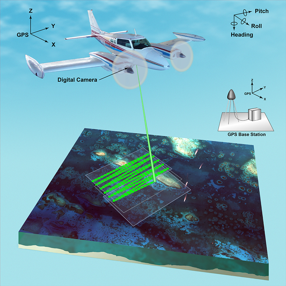
Aircraft, both crewed and uncrewed, are equipped with airborne lidar, GPS, and digital cameras to map and measure land elevations across large areas of the Earth.

Airborne lidar system. Lidar, short for light detection and ranging, is a remote sensing detection system that works on the principle of radar, but uses light from a laser. The quick light pulses measure the distance from the plane to the surface and back. This illustration depicts the equipment used, including the plane with digital camera mounted underneath, and the GPS base station, but does not show the satellites used to obtain the coordinates. Illustration: USGS
These data sets are then used to categorize the mapped areas into specific land-use and land-cover categories and measure biomass, which informs agricultural, forest, and mineral resource assessments and land management decisions. The U.S. Geological Survey uses lidar data to manage water resources and identify areas prone to landslides and other geological hazards. lidar elevations are used by the Federal Emergency Management Agency (FEMA) to create floodplain maps to better understand flood risks.
NOAA uses these data sets in a wide range of critical monitoring activities, including:
NOAA’s bathymetric lidar systems use frequencies of light that penetrate water and are used for mapping clear rivers and shallow coastal bathymetry much more safely and efficiently from the air than the historic method of sending survey crews out into difficult and dangerous environments. Beyond providing data for the nautical charts, this underwater lidar data is used to map the marine environment’s benthic habitats (the ecological region at the lowest level of a body of water) for fishes, sea turtles, marine mammals, and seabirds.
Lidar data collected from NOAA aircraft is used to determine the National Shoreline, and is combined with sonar data from NOAA ships to create the United States’ official nautical charts. Ships from around the world move $1.5 trillion worth of products in and out of U.S. ports every year and rely on these navigation charts to do so safely.

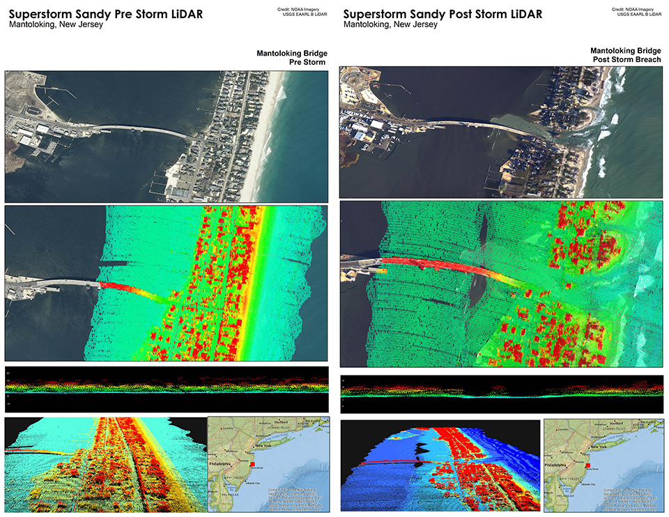
This visualization was designed by the UNH/Marine Program to illustrate the use of lidar data in a storm response scenario. Using a combination of NOAA photogrammetry data and US Geological Survey EAARL-B lidar data, the before and after displays illustrate the damage caused to the Mantoloking Bridge (Mantoloking, NJ) due to a barrier island breach caused by Super storm Sandy.
NOAA’s Weather Service and other partners point a lidar’s lasers to the sky to measure clouds and different types of particles in the atmosphere to better predict the weather and understand our changing climate.
The availability of lidar and other geospatial data is growing faster than ever, but the number of people that know how to harness it and apply it is still low. This means that there is a great need and high demand for people with the skills to collect and apply this technology. The geospatial technology job market is hot, and there are plenty of opportunities to work on critical issues. So, if you like working outside, solving puzzles, and playing with cool technology, consider a career (or even some classes) in surveying and mapping!
Galen Scott is the constituent resources manager for the National Geodetic Survey. He is responsible for engaging stakeholders about NGS products and services and generating feedback to better serve our users’ needs. Galen also leads the NGS GPS on Bench Marks program, a crowd-sourced data collection effort to help the geospatial community prepare for the modernization of the National Spatial Reference System.
Social