This learning sequence incorporates three dimensional learning from the K-12 Framework for Science Education with connections to Common Core, and the Maryland Environmental Literacy Standards.
The sequence was originally conceptualized by a team of educators from the Chesapeake Bay region: Eric Greenlee (Anne Arundel Public Schools), Patricia Benner, Merrilee Perko, and Pamela South (Somerset County Public Schools), and Katie Seman (Wicomico County Public Schools).
The sequence is comprised of seven lessons, each building on the knowledge and skills of the previous one incorporating the three dimensions of learning. These dimensions are included in each lesson and the learning sequence builds toward deeper understandings and issue investigation skills. (http://www.nextgenscience.org/three-dimensions)
The lesson sequence will engage students in a local environmental issue by showing them the historical context of how the Eastern oyster populations and the Chesapeake Bay watershed have changed since the time of Captain John Smith. Students learn about water quality parameters and have opportunities to investigate the effect of land use on water quality and ultimately the oyster populations and the reef ecosystems. Finally, students are asked to learn about the effect of management practices on water quality and asked to suggest ways that these can be used to increase the health of the Chesapeake Bay ecosystem and its water supply through healthy oyster reef systems. The sequence of seven activities is divided into 2 modules building toward skills and knowledge to tackle more in-depth issue analysis in the high school sequence.
There are two modules in the unit with these Essential Questions:
- Module 1: Then and Now | Where Am I? | Water, Water | Land Use and Water Quality
- - How have the physical characteristics of the Chesapeake Bay changed since John Smith first sailed it in 1608?
- - How have habitats and abundance of animal species changed since 1608?
- - What tools can be used to determine location?
- - Why is it important to know location in science investigations?
- - What are the biotic and abiotic conditions in waterways where we are?
- - How can we tell if our stream is healthy?
- - What is the water quality where I live?
- - What land use factors influence water quality?
- - How does the water quality where we live compare with other areas of the state?
- - What management strategies can be used to improve the health of the Chesapeake Bay?
- Module 2: Oysters: Inside and Out | Oyster Harvest Simulation | Save the Oyster Reef!
- - What role do oysters play in water quality?
- - How does oyster anatomy function to provide filtering of Bay water?
- - What organisms depend on the oyster reef ecosystem?
- - How have harvesting techniques and oyster diseases affected oyster populations in the past?
- - How has more efficient harvesting techniques affected oyster reefs?
- - How are oysters important to Chesapeake Bay’s water quality?
- - What aspects of water quality are important for oyster growth and reproduction?
- - What management strategies can improve both the water quality and the health of the Bay’s oyster ecosystem?
Module 1, Lesson 1: Then and Now
Teaching Time: 1-2 class periods
In Lesson 1: Then and Now, students will explore the historical changes in the ecological conditions and water quality of the Chesapeake Bay. Students will confirm or refute their predictions after reading excerpts from John Smith’s journal and viewing reports from the Chesapeake Bay Foundation or other sites. This activity will set the stage for students to investigate waterways near them and to look at the role of
oysters in the Chesapeake Bay ecosystem.
Captain John Smith was an English explorer who played a pivotal role in the European settlement of America. His contact with Native Americans and his Chesapeake voyages was documented in maps and journals helped early English colonists to learn about the region. Smith led two voyages on the Bay. His journal entries give us a clue about the ecological conditions of the Bay at the time.
One of the most visible changes is the amount and diversity of animals that live in and around the Bay. In Smith’s days, oysters “lay as thick as stones,” and the Bay contained more sturgeon “than could be devoured by dog or man.” During Smith’s time, the land surrounding the Bay was home to bears, wolves, cougars, falcons, partridges, waterfowl, and had cypress trees that were 18 feet around the base and up to 80 feet tall. The water then was substantially clearer as well.
Students will be able to:
- Explain 3 differences in the physical conditions of the Chesapeake Bay from the 1600’s
and today.
- Characterize relative abundance and diversity of living species near the Chesapeake Bay
in 1600.
- Identify 3 characteristics of a healthy Chesapeake Bay ecosystem.
Materials
- Access to websites or printed resources about John Smiths’ journeys
- Copies of Student Data Handouts
Module 1, Lesson 2: Where am I?
Teaching Time: 2-3 class periods
Module 1, Lesson 2: Where Am I? explores geospatial systems so that students can create waypoints and record latitude and longitude of places in a watershed as a first step in monitoring a local waterway. These skills are basic to understanding how locations are found on earth with the use of maps, coordinates, and technology.
Humans have looked to the skies to find their way since ancient times. Ancient sailors used the constellations in the night sky to figure out where they were and where they were going.
Today, all we need is a simple hand-held GPS (short for Global Positioning System) receiver to figure out exactly where we are anywhere in the world. However, we still need instruments high in the sky to figure out where we are and how we get to other places.
Instead of stars, we use Global Positioning System (GPS) satellites, to help determine a location on the planet. The concepts behind GPS positioning are very simple, but the application and implementation require amazing precision. Over 30 navigation satellites are zipping around high above Earth. These satellites can tell us exactly where we are. GPS is a system. It’s made up of three parts: satellites, ground stations, and receivers. (http://spaceplace.nasa.gov/gps/en/)
Students will be able to:
- Explain the concept of locating a site on Earth with 3 satellites.
- Use latitude and longitude coordinates to identify features on a map.
- Use a GPS receiver or a smart phone to locate the waypoint of a local feature on the school grounds.
Materials
- Student Handouts 1-3
- For each group doing the Trilateration activity:
- 4 pieces of different colored string
- pencil or pen
- large map
Module 1, Lesson 3: Water, Water
Teaching Time: 3-4 class periods
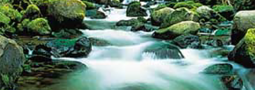
Students will measure water quality and its relevance to stream health by understanding water quality parameters. They will use standard water testing equipment to test and record precise measurements of water quality and learn about the indicators of a healthy waterway and the role oysters provide in a healthy Bay ecosystem.
Water quality is a measure of how suitable water is for a particular use based on certain physical, chemical, and biological characteristics. Scientists measure water temperatures, turbidity (clearness of the water), and other “indicators” to monitor the health of the Chesapeake Bay. Students will assess the water quality of a local stream or river, and compare their findings to published data of tributaries in the Chesapeake Bay. Ideally, water quality testing will continue throughout the school year, so the students can observe and try to explain trends in the data and begin to think about the consequences of human actions.
Students will be able to:
- List 3 indicators of water quality and explain how information about these are obtained.
- Give an example of how water quality indicators affect living organisms.
- Give an example of how weather events might affect a water quality indicator.
Materials
- Student Data Sheets 1 and 2
- Water Test Kits (Dissolved oxygen, Salinity)
- Data sheet
- Probes (from Vernier, Hach, LaMotte)
- Lead line
- Secchi disk or turbidity tube
- Pencils
- Clipboards
- Measuring tape
- Thermometer
- Anemometer (wind meter)
- Compass
- PFDs
- Hand sanitizerv
- Bucket with rope
- pH pen
- Water test kits for dissolved oxygen, temperature, salinity, nitrates, pH, depth. Your school may already have water test kits but if not, you can purchase them from scientific companies or LaMotte, Hach, Hanna or local hardware stores.
Module 1, Lesson 4: Land Use and Water Quality
Teaching Time: 4-6 class periods
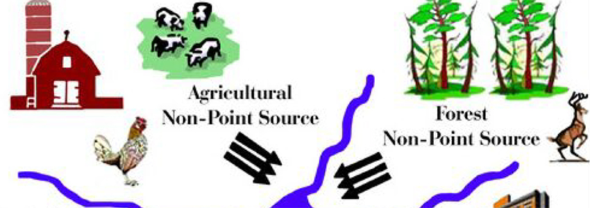
This activity investigates local watersheds and what land use factors influence water quality of the rivers and the Bay. Students then look at data from a local monitoring station to find the health of their stream. Using maps of land use areas in parts of the Bay, students will look at land use and compare that with local stream health. They will learn about point and non-point source pollutants and determine possible local sources; then they will consider ways that these can be managed or reduced to enhance water quality, just one step in restoring oyster populations.
The simplest definition of a watershed is the area of land that catches precipitation and channels this water into a marsh, stream, river, lake, or underground reservoir (groundwater). These water bodies can be contaminated by runoff that carries pollution from land surfaces anywhere within the watershed. Pollution is the presence of substances in the air, land, or water that can degrade human health and environmental quality. These substances may come from many sources, but some of the most serious pollution problems are the result of unwanted by-products—commonly called wastes—from human activities.
Students will be able to:
- Explain the concept of a watershed in visual or verbal forms.
- Compare point and non-point sources of water pollution and give an example of each.
- Give 3 examples of how land use can affect water quality.
- List 3 ways that soil erosion can be minimized in a watershed.
- Identify 4 best management practices to reduce water pollution.
Materials
- Copies of Student Data Sheets 1, 2, 3 and 4
- Color copies of the Chesapeake Bay watershed in Student Data Sheet 1
(consider laminating map and provide one per pair of students)
- Access to computers to find their watershed address, local monitoring stations and water quality data
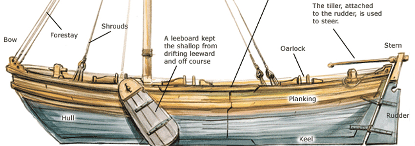
This activity explores the physical characteristics that make oysters efficient filter feeders through an investigation into oyster external and internal anatomy. They will design a water filter and test its function with dirty water, then investigate the ecosystem services that oyster reefs provide to organisms that depend on oyster reefs.
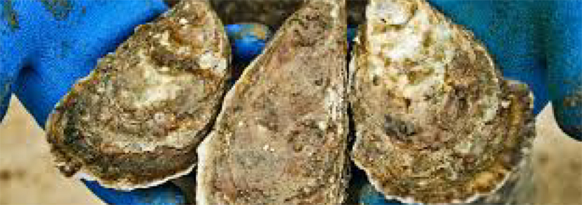
Oysters have remained relatively unchanged for 190 million years. This mollusk is found throughout much of the Bay in water depths up to 100 feet, although today they are rarely found below 30 feet. The adaptive nature of the oyster in a changing estuarine environment has allowed it to become extremely successful. This success is also due to its simple anatomy and it ecological niche.
Aquatic reefs are complex, diverse communities made of densely packed oysters. Healthy reefs form when oyster larvae attach to adult oysters, and layers of oysters grow upward and outward. Hundreds of aquatic animals find food and shelter in oyster reefs.
Students will be able to:
- Identify the form and function of oyster anatomy that make oysters efficient filter feeders.
- Compare oyster filter feeding anatomy with student-created filters.
- Explain the importance of oysters and oyster reef habitats to the Chesapeake Bay.
- Examine and identify organisms living in the oyster reef community.
Materials
- Live oysters and oyster clumps
- 5-10 gal aquarium
- Small plastic cups
- Rubber bins
- Dip nets
- Bucket
- Magnifying glasses
- Hand sanitizer
- Paper towels
- Organism identification key
If available:
- Compound microscope
-
Plastic culture dish
-
Dissecting microscopes
-
Life in the Chesapeake Bay 3rd edition, Alice Jane Lippson and Robert L. Lippson
Module 2, Lesson 2: Oyster Harvest Simulation
Teaching Time: 1-2 class periods
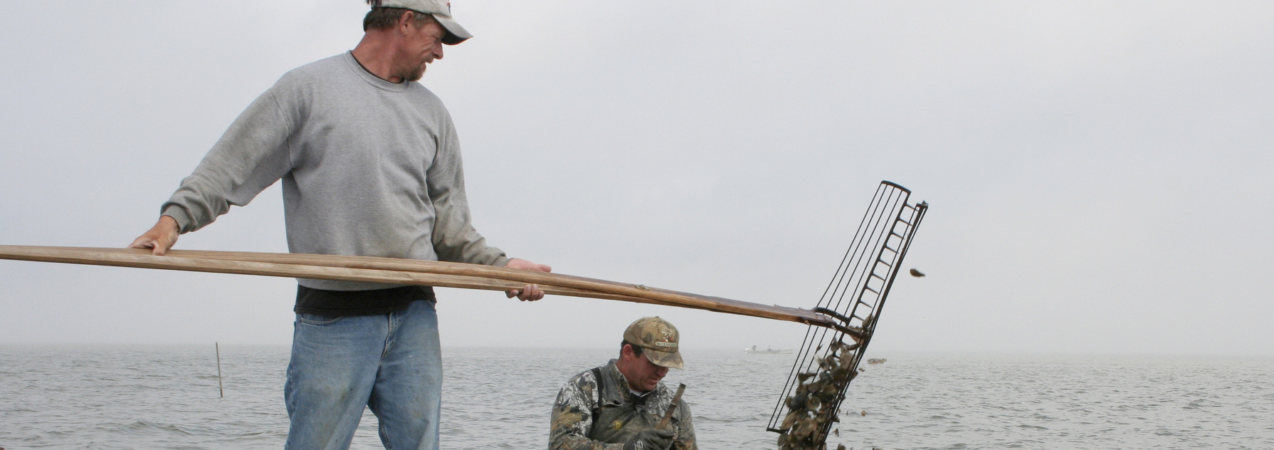
This activity explores the historical and technological changes in the harvest of oysters through the years. It encourages students to think about how humans have affected the Bay and the Eastern oyster. During the game, dried beans represent oysters, and students test out four different types of oyster harvesting tools; nippers, hand tongs, skipjack dredges, and power dredges. After each round of “harvest”, students observe and discuss how the structure of the reef has changed, and how the physical changes affect oysters and future populations.
At one time, oysters were so abundant in the Chesapeake Bay that their reefs defined the major river channels. The reefs extended to near the water surface; to stray out of the center channel often posed a navigational hazard to ships sailing up the Bay. The oyster population in the Bay is less than 1% of what it once was. This activity will investigate one factor in the oyster population decline in the last 130 years, harvesting methods.
Students will be able to:
- Explain three methods of oyster harvest and how each method can impact oyster populations and oyster reef structure.
- Explain how a change in reef structure affect oyster populations.
Materials
- Student Data sheets 1 and 2
- Cookie sheet or watershed map
- 1 bag of dry white beans
- 1 bag of dry black beans
- Several pairs of chopsticks
- Several plastic spoons
- Several pairs of salad tongs (the kind that is connected with a pivoting pin in the middle)
- Small measuring cups of equal size/li>
Module 2, Lesson 3: Save the Oyster Reef!
Teaching Time: 1-2 class periods
Oysters are a valuable part of estuary ecosystems. They help purify the water, control erosion, and provide habitat for numerous other species. In this activity, students will investigate a hypothetical scenario in a town on the Chesapeake Bay, and devise a management plan to “Save the Oyster Reef”.
Since colonial times, the Chesapeake (meaning "great shellfish Bay" in Algonquin) has lost more than 98 percent of its oysters. Gone are the days when oyster reefs posed navigational hazards to Chesapeake Bay explorers. Their reefs defined the major river channels. The reefs extended to near the water surface and often posed a navigational hazard to ships sailing up the Bay. Now, after decades of damage to reefs from harvest, increased disease, falling salinity due to the increased runoff that accompanies increased impervious surface, and increased sedimentation from runoff, a significant amount of hard bottom habitat has been lost. The oyster population in the Bay is less than 1% of what it once was. The native Eastern oyster—Crassostrea virginica—plays an important role in the Bay's ecosystem, as both a habitat for a variety of sessile plants and animals and free-swimming fish and shellfish, and as filter feeders because they feed upon phytoplankton (algae).
Students will be able to:
- Explain the water quality requirements for healthy oyster populations.
- Given water quality data, determine whether the water quality will allow oyster growth and spawning.
- Suggest 3 management practices that can be used to improve water quality for oyster growth and reproduction.
Materials
- Copies of Student Data Sheets
- Water quality parameters, data, and best practices information from previous activities
 An official website of the United States government.
Here's how you know we're official.
An official website of the United States government.
Here's how you know we're official.