With the use of unmanned systems, NOAA is reducing operational costs and manpower requirements, while increasing the type and quality of data that NOAA collects. In this episode, Rob Downs from NOAA’s Office of Coast Survey explains the past, present, and possible future of unmanned systems at NOAA.
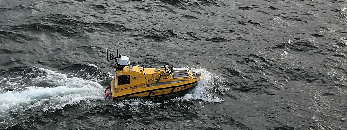
This is a Bathymetric Explorer and Navigator, or BEN. It's a 13-foot diesel-powered unmanned surface vehicle that has an endurance of over 16 hours and is equipped with a standard suite of hydrographic survey equipment. Here, BEN is shown underway from NOAA Ship Fairweather off Point Hope, Alaska, July, 2018.
Transcript
HOST: This is the NOAA Ocean Podcast. I’m Abby Reid.
When you hear the word “robot,” what comes to mind? Artificial intelligence? Machines that think for themselves? Pop culture is filled with references to robots. Here at NOAA we call them “unmanned,” or “autonomous,” systems. While their level of sophistication is nowhere near something you’d read about in a science fiction novel, these systems play an important role in the work that NOAA does.
I spoke with Rob Downs from NOAA’s Office of Coast Survey to find out how NOAA used unmanned systems in the past, how they’re used now, and how they might be used in the future.
Here’s Rob.
ROB DOWNS: My name's Rob Downs. I work in NOAA’s Office of Coast Survey in the Coast Survey development lab. And I am the project manager and technical lead for unmanned systems in the Office of Coast Survey.
HOST: Thank you. What are some examples of different kinds of autonomous systems, and what functions do they serve?
ROB DOWNS: Well in Coast Survey we’re using unmanned underwater vehicles that are also called Autonomous Underwater Vehicles, or AUVs, and we’re using Unmanned Surface Vehicles, or USVs. So small boats from manned portable, like 3- foot long unmanned boats that look sort of like small remote control boats, all the way up to where we're putting unmanned brains in one of our 30-foot, 15,000 pound survey launches.
HOST: “Unmanned brains.” That’s an interesting term. Can you, can you talk about that a little bit?
ROB DOWNS: So with autonomous systems or unmanned systems there's, there's a computer that has to reside in the system and that computer takes instructions from the operator, but it can also bring in sensors both for the sensors we use to collect data, like multibeam or sidescan sonar sensors, as well as cameras and radar and AIS — the Automatic Identification System that ships use to broadcast their names and positions. And so the the unmanned brains processes that data, can present situational awareness through the cameras and radar back to the operator, or make decisions based on that if it’s an advanced enough system. Really the sophisticated parts of those systems are the computers and the software that are the brains that are actually executing instructions, and perhaps even making some decisions.
So in Coast Survey, NOAA’s Office of Coast Survey, what we’re most interested in is the seafloor mapping data because we produce nautical charts. So we're looking for wrecks, rocks, and obstructions, and also looking to measure the bathymetry, or the total water depth, so that we can chart those depths for safe navigation.
But across NOAA, unmanned systems are being used for other oceanographic observations or sea floor mapping for fish habitat or archaeological studies, but they can also collect what we call water column data, so temperature and salinity profiles, or dissolved oxygen, or other oceanographic parameters that are beneficial to both biologists and other oceanographers.
And current data, so it can be used for developing models that can be used for storm surge inundation or models that can be used for weather forecasting.
HOST: When did NOAA start using autonomous systems, and what were they used for?
ROB DOWNS: In NOAA’s Office of Coast Survey we first started using unmanned systems in 2004. We bought a small man portable unmanned underwater vehicle or Autonomous Underwater Vehicle, an AUV, and it had side scan imaging sonar in it, which can detect obstructions and rocks and wrecks on the seafloor. And over a few years of using that vehicle on special projects, we did a pollution response drill with other parts of NOAA and the Coast Guard in San Francisco. We mapped illegal lobster habitat in the Florida Keys National Marine Sanctuary; we mapped unexploded ordnance debris in Vieques, Puerto Rico; and we were just using those projects as opportunities for us to gain experience and familiarity with the system. And those small unmanned underwater vehicles we realize had a great benefit because they're easily portable. We use them now for special projects and emergency response.
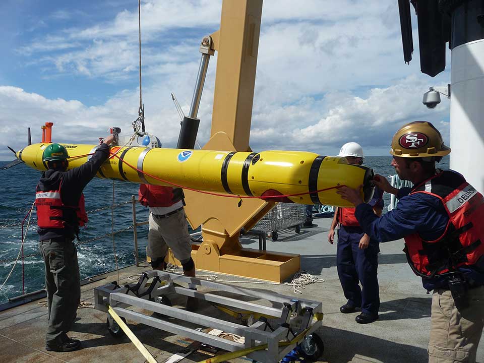
NOAA’s Office of Coast Survey's REMUS-600 Autonomous Underwater Vehicle (AUV) aboard NOAA Ship Ferdinand R. Hassler is recovered off of the coast of Maine following a seafloor mapping mission. The REMUS-600 AUV is 12 feet, weighs 650 pounds, has an operational endurance of 24 hours, survey depth range to 1,640 feet, and is equipped with highly accurate positioning, navigation, and multibeam sonar systems for seafloor mapping.
So Coast Survey has a responsibility to survey ports for hazards to navigation following incidents, whether it’s a shipping incident, or more commonly a storm like a hurricane, would come into a port. We have manned teams with small boats that will be deployed to the area to survey after the storm, and we’ve used the unmanned systems to survey as well. And the small unmanned systems provide us a great deal of flexibility because we can ship them there commercially, we can transport them around in the area in the back of rented SUVs or pick-up trucks, and deploy them from what we call vessels of opportunity.
HOST: Could you just define for our listeners what a vessel of opportunity is?
ROB DOWNS: A vessel of opportunity is a vessel that’s not necessarily owned by NOAA but is an available boat, platform, for us to do operations from. So we have portable survey equipment that we can temporarily install on someone else’s vessel and use that for seafloor mapping, but those vessels of opportunity, or those temporarily available vessels also can serve as platforms for us to operate unmanned systems from.
HOST: What are the benefits of using autonomous systems, or unmanned systems?
ROB DOWNS: The potential benefits of using unmanned systems include efficiency. So sometimes it’s referred to as a “force multiplier.” So we have manned platforms, some of our hygrapgrahic survey ships have four small boats that are on them with mapping equipment as well. So they’ll go to remote areas — like Alaska or the Arctic — and the ship will map, and the four small boats will go out and map, but it’s really expensive to send a ship out to a remote area. So unmanned systems can be used to add additional survey capabilities to those platforms. So while the ship’s surveying, and the small boats are surveying, we could also potentially put unmanned systems in the water as well. And so in the short time that we have in a survey field season, given weather, and you know, the remote reaches of the Arctic, we could potentially collect more data if we're using unmanned systems than if we were just relying on manned platforms. But, unmanned systems still do require some supervision and personnel.
Some of the other benefits of unmanned systems is that they can provide data in areas that are otherwise inaccessible. For example, our shipboard systems that do seafloor mapping are limited in the depth that they can provide high resolution data. So if we want a really detailed map of the seafloor, it’s difficult sometimes to get that from a ship board system. So the unmanned underwater vehicles can dive deeper, and get that sonar sensor closer to the seafloor, and provide much higher resolution.
HOST: Can you share an example of a time when an unmanned system helped achieve an expedition’s mission?
ROB DOWNS: I think that the best example of where our use of an unmanned system was very effective and helped us achieve our mission more quickly was the post-hurricane Ike survey in Galveston, Texas. Because of the portability of the small unmanned underwater vehicle, we were able to be on site and ready to survey less than 24 hours after the storm had passed. And at that point there weren’t other survey boats available in the area. There really weren’t boat ramps available to launch a small boat, because they were covered in debris. So with a team of two people we traveled with a small unmanned underwater vehicle. We coordinated with the Coast Guard to work off of one of their 55-foot buoy workboats. And we were able to do a post-storm survey looking for hazards to navigation in Galveston Harbor using the unmanned vehicle. And while it was deployed and surveying, the Coast Guard vessel transited several miles away to repair buoys and other aids to navigation. So that kind of combined effort provided the Coast Guard and NOAA more quickly the information that they needed and the repairs that needed to be done to re-open the port to commercial traffic.
HOST: How would you describe the level of sophistication of autonomous systems, and how involved are humans in interacting with autonomous systems? It sounds like there’s a range, but if you could just talk a little bit about that range, that would be great.
ROB DOWNS: The range of autonomous capabilities goes from remotely controlled, like a toy boat, where you actually have a handheld joystick and an operator is driving the platform. All the way to some of the emerging, like fully autonomous systems, that have decision-making capability. But most of the commercially available systems and the systems that NOAA is currently using fall somewhere on a spectrum in between there.
So the unmanned underwater vehicles are sort of rudimentary autonomous. It may appear that they’re like very autonomous systems because no one’s remotely controlling it, we’re not in constant communication with it, but the technology is still sort of basic. It’s just doing what it’s told.
HOST: Do you work with partners outside of NOAA to develop and use autonomous systems?
ROB DOWNS: Yes. NOAA provides funding to both the University of New Hampshire and the University of Southern Mississippi through grant programs, and both of those universities are doing some research and development work and operational testing work for NOAA on unmanned systems.
And then there’s also commercial partnerships. So we are currently working with a contractor to retrofit one of our 30-foot hydrographic survey launches with components so that it can operate either as a manned boat, traditionally, as we use it now, or also operate as an unmanned boat.
I think NOAA is contributing to the advancement of unmanned systems both from our operational test and evaluation of the systems. I think some of our unique requirements for unmanned systems to meet our mission needs have driven some of the choices that commercial companies have made on, on what they provide in their unmanned systems.
HOST: Do autonomous systems replace the need for NOAA ships?
ROB DOWNS: Autonomous systems absolutely do not replace the need for NOAA ships for several reasons. First, just for the safe operation of some unmanned systems depending on the area, ships are necessary and people are necessary to provide oversight, or situational awareness, for the unmanned system so that it can safely operate. A lot of the unmanned systems that we use because of the power requirement for the sensors that we use, the sonars, the multibeam sonars and the side scan sonars — those unmanned systems don’t have a really long endurance. The endurance could be as short as four hours, and potentially as long as 24 hours. So we rely on ships to get those systems to the places that we’re interested in surveying.
HOST: Rob, I want to thank you for coming here today and talking to us about autonomous systems, unmanned systems. It’s been a pleasure.
ROB DOWNS: Thanks for having me. I love talking about it.
HOST: From seafloor mapping to emergency response, from AUVs to USVs, “unmanned,” or “autonomous” systems are giving NOAA the flexibility to use its resources in smart, efficient ways. To learn more about unmanned systems, or any ocean-related subject, visit our website at oceanservice.noaa.gov.
Did you know?
NOAA's Office of Coast Survey is the nation’s chartmaker, with over a thousand charts covering 95,000 miles of shoreline and 3.4 million square nautical miles of waters within the U.S. Exclusive Economic Zone.
 An official website of the United States government.
Social