Gliders: Versatile Vehicles for Underwater Observation
NOAA Ocean Podcast: Episode 65
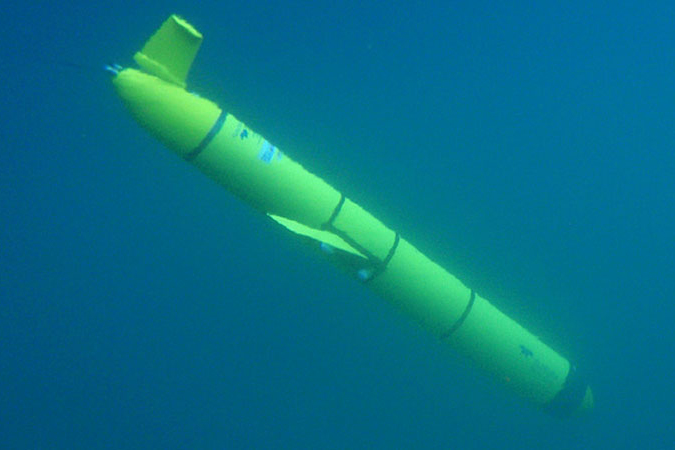
Gliders are autonomous, uncrewed, underwater vehicles that collect data — providing scientists with a more complete picture of what is happening in the ocean and the Great Lakes. In this episode, we dive deep with Kathleen Bailey, glider program manager with NOAA’s U.S. Integrated Ocean Observing System, to learn more about these versatile vehicles.
Gliders can collect data about a wide variety of conditions, including water temperature, pressure, and salinity. This information can be used for different applications, such as detecting and monitoring marine heatwaves, harmful algal blooms, and hypoxia events.
Listen here:
Or listen in your favorite podcast player:


Transcript
HOST: This is the NOAA Ocean Podcast, I’m Marissa Anderson. In this episode, we dive into the world of gliders and learn how these small underwater vehicles provide us with valuable information about our ocean and Great Lakes. We’re joined by Kathleen Bailey, Glider Program Manager with NOAA’s U.S. Integrated Ocean Observing System or IOOS. To kick off our discussion, I asked Kathleen to tell us what gliders are all about.
BAILEY: Gliders are autonomous, uncrewed, underwater vehicles meaning they are completely untethered and they roam around on their own for weeks, up to many months at a time. So basically, they are like aquatic robots that dive up and down in the water column and they look like little torpedoes, but without an engine or a propeller so they’re about five to six feet long and they have wings attached to their side. You can attach various sensors and collect a variety of different types of measurements, from the water surface, down to the bottom of the ocean without any human presence.

Kathleen Bailey, glider program manager, NOAA’s U.S. Integrated Ocean Observing System
HOST: I liked how you described them as aquatic robots. Can you explain how gliders work? What is the process, from start to finish?
BAILEY: The way that they’re deployed in the water, is they’re basically put on a boat and shipped out into the ocean and then a scientist will drop the glider overboard. And the way it works is, basically it uses buoyancy and gravity to fly, so there’s no engine or propeller, and how that works is, the glider draws water in to make itself heavier than the surrounding water, enabling it to sink and then internal weights move forward to angle the glider downward so that it flies towards the seafloor. And than as it’s sinking, a depth sensor tells it when to stop and turn around before it hits the bottom or whatever depth it’s programmed to reach, and than at that point, it pumps the water out to make itself lighter and the weights move back to pitch it upwards and than that allows it to slowly climb back to the surface. So they also have wings attached to the side, that generate lift and that gives the glider forward motion and also helps stabilize its flight. So a typical glider dive will go from the surface of the ocean down to about a thousand meters and back in about six hours, covering about six kilometers of horizontal distance in that time. And then when the glider does reach the surface, it sends all the data collected throughout its dive through satellite communications back to shore to an IOOS data hub.
HOST:What kinds of data do the gliders collect?
BAILEY: Almost all gliders measure at least water temperature and salinity and pressure. And then some additional data types include water currents, acoustics for listening to marine mammals for example, dissolved oxygen, chlorophyll, fluorescents and nitrate, acidity, carbon dioxide concentration, and then optical sensors as well.
HOST: That sounds like such a great wealth of information. What would be the applications gliders would be used for when they collect this data?
BAILEY: They’re used to detect and monitor marine heatwaves, harmful algal blooms, and hypoxia events. They’re used for hurricane forecasting, so they’ll measure upper ocean heat content and monitor ocean features like eddies, that we know to influence hurricane intensity and at times cause those rapid intensification events where a hurricane can explode from a category 1 to a category 4 storm for example. They’re also used for monitoring water quality, which impacts fisheries. The acoustic sensors are used for fish stock mapping and right whale monitoring, which you might have heard about in the news lately. Oil spill responses is another application. They’re used for monitoring and measuring ocean acidification and there are also climate applications, so there’s a network operated off the coast of California by Scripps Institute of Oceanography that has been continuously running gliders along a handful of transects for almost twenty years, gathering baseline observations on climate variability. They’re also used for mapping the seafloor and hydrographic mapping.
HOST: So I know you said they don’t need a human presence, but can humans actually control them?
BAILEY: Yeah, definitely. There’s actually a pilot onshore at a computer terminal, basically checking on the glider throughout its entire mission and sending it commands when it surfaces, telling it where to go next. Piloting gliders requires expert knowledge about the local oceanography so when a person is sitting onshore monitoring the glider and where its going, sometimes it encounters an eddy or a gulf stream, you know, something that with strong currents that can be a little challenging for the glider to navigate, since as I mentioned that it doesn’t have a propeller, meaning you can’t just purchase a glider and throw it in the ocean and expect immediate success. So we have IOOS regional pilots who have deep knowledge about their local, regional environment in which they’re flying the gliders and they have built up years of understanding.
HOST: What are some of the benefits with a glider being autonomous, and not needing humans directly involved in their missions?
BAILEY: So one major benefit is their long endurance. They provide long, continuous measurements of water column properties or characteristics over a long period of time up to, as I mentioned earlier, months at a time. Which isn’t practical for a crewed vessel with people on it, like a ship. And of course they can also travel to difficult to reach areas and in severe weather conditions, so in that case, we don’t need to worry about a safety of a crew because it doesn’t have a crew. And because of this autonomy, they also operate at a fraction of the cost of a crewed vessel.
HOST: So between helping keep humans safe and the cost savings, it sounds like gliders are considered to be important tools for collecting ocean data.
BAILEY: The value of these tools as scientific platforms really lies in their ability to carry small low power sensors for those long durations, you know, months at a time, over long distances. Also, we’re seriously lacking continuous, real-time, subsurface ocean data. We have a ton of surface data available to us from remote sensing instruments that are on satellites, but we have very little below the surface and the NOAA modelers really need that information to help improve the ocean models so gliders are really helping to fill that observing gap.
HOST: This is the NOAA Ocean Podcast. Thanks for listening. Check out our show notes to learn more about gliders and the glider program. Make sure you subscribe to us in your favorite podcast player and catch our next episode soon!

From corals to coastal science, connect with ocean experts to explore questions about the ocean environment.
More Information
Social