Behind the Scenes at NGS
NOAA Ocean Podcast: Episode 73
With origins tracing back more than 200 years, NOAA’s National Geodetic Survey is in the business of “knowing where things are.” In this episode, we go behind the scenes with NGS Director Juliana Blackwell to get an insider perspective on NGS’s history and mission. She also shares her personal experience as the office’s first female director.
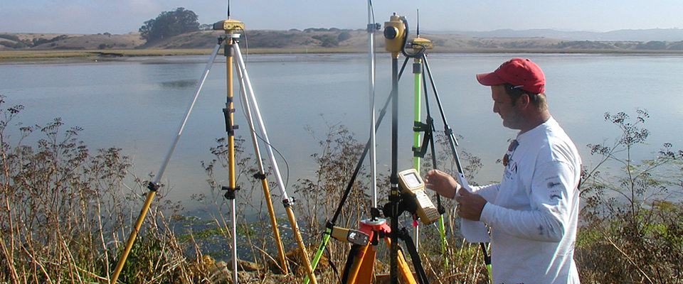
Many organizations use geodesy to map the U.S. shoreline, determine land boundaries, and improve transportation and navigation safety. To measure points on the Earth’s surface, geodesists assign coordinates — similar to a unique address — to points all over the Earth.
Listen here:
Or listen in your favorite podcast player:


Transcript
HOST: This is the NOAA Ocean Podcast, I’m Marissa Anderson. You may not be familiar with NOAA’s National Geodetic Survey, or NGS for short, but its important work in the science of geodesy touches many aspects of our lives, every day. In this episode, our guest is Juliana Blackwell, director of NGS. Juliana gives us an insider perspective on the National Geodetic Survey — from the mission of the organization and its history, the role of geodesy in our daily lives, and her pioneering career as its first female director. Let's dive right into our discussion…
BLACKWELL: The National Geodetic Survey is the oldest hidden scientific gem of the federal government and also “the” office within NOAA which makes knowing exactly where things are possible — including hidden treasure.
The mission of NOAA’s National Geodetic Survey is to provide the nation with the best possible, most accurate spatial reference system, or foundational framework, for determining the exact location of everything. Think “latitude, longitude, and elevation” and how critical exact positions are in our everyday life. An accurate and precise positioning framework provides the coordinates, or the starting points, for projects and activities all around us — constructing transportation systems; building infrastructure; surveying land and sea; mapping floodplains; navigating and operating cars, ships, planes, and uncrewed vehicles — and connecting all types of geospatial information and data used in our daily lives.
HOST: Can you provide the 30,000-foot view of what geodesy is? Some of our listeners may not be familiar with the term. And why is geodesy important?
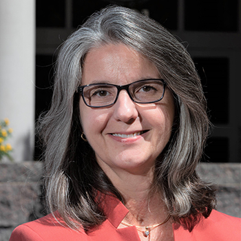
Juliana Blackwell, director, NOAA’s National Geodetic Survey.
BLACKWELL: Well, the Earth isn’t a perfect sphere, and it’s constantly changing. Geodesy is the science of measuring the size and the shape of the Earth, its orientation as a planet in space, and how the Earth’s position, size, and shape change over time. In addition to sudden changes in the Earth’s crust, such as earthquakes, there are less noticeable processes, including subsidence and tectonic plate motion, which change the Earth’s shape and the location of where things are on Earth.
HOST: Thank you for walking us through that definition. Geodesy is so wide-ranging and impactful. People often use it every day without realizing it. Could you provide some examples of how it's a part of our everyday lives?
BLACKWELL: Let’s start with GPS. Global Positioning System technology is embedded in our smart phones, our watches, cars, tractors, construction vehicles, and so much more. But how does your GPS device know where you are in relation to your surroundings? The accurate positioning of roads, buildings, and surrounding obstacles referenced to a common geodetic framework through GPS, allows safe navigation and positioning information.
Geodesy makes that possible. Gravity is also another component of geodesy and an important part of our daily lives. Gravity pulls objects toward the center of the Earth. Did you know that gravity isn’t the same everywhere? It varies as a result of the Earth’s mass, density, and rotation. Geodesists measure the variations in the Earth’s gravity field to determine accurate heights and elevations. Accurate gravity and elevation information are critical to determining where water will flow and determining flood risk.
HOST: That’s so interesting to note on the differences in Earth’s gravity field, and that the work that geodesists do helps provide us with safer navigation and transportation. Now, I’d like to switch gears and get into the history of NGS, and talk about you and your career.
The National Geodetic Survey was established as the Survey of the Coast by President Thomas Jefferson in 1807. How has NGS and the science of geodesy evolved throughout the years?
BLACKWELL: Over the past 200+ years, NGS has enlisted state-of-the-art equipment and advanced surveying techniques to survey the coastline, to create nautical charts, extend and update the geodetic network across the country, chart the nation’s airways, and advance the science of geodesy. Human line-of-sight measurements have given way to satellite systems in space used for positioning on, and imaging of the Earth. The science of geodesy is truly now a global endeavor. GPS and other satellite observations have revolutionized the measurement and understanding of the Earth’s size and shape and its ever-changing nature. Looking back to the earliest surveys, I am amazed by the accuracy of the networks and credit the dedicated professionals who were the first geodesists of NGS.
HOST: You are the longest-serving director of the National Geodetic Survey and the first female director. What made you decide to have a career in the science, technology, engineering, and mathematics — or STEM — field?
BLACKWELL: I love numbers! Math was always my favorite, and best subject in school. In high school and college, I concentrated on math and science courses. In college I had studied physical sciences and majored in math. But it wasn’t until I joined NOAA that I discovered “geodesy,” which is a perfect blend of math and science! My first job with NGS was a field assignment conducting geodetic surveys and learning from the ground up! Once I discovered NGS, I knew it was the place for me!
HOST: What was it like coming up as a female scientist and leader at NOAA? And how do you feel this uniquely positioned you to make an impact in the organization?
BLACKWELL: I was the only woman on the survey crews when I first joined NGS. I had a very positive experience. Some of the colleagues I worked with in the field are still with NGS today. While I don’t consider myself a surveyor by any means, I feel that learning the basics of geodetic surveying and data processing helped me establish myself as a manager and leader.
HOST: Looking back on your time at NGS, is there a particular accomplishment that you are most proud of?
BLACKWELL: Organizationally, I am most proud of the NGS workforce and their dedication and professionalism in support of NGS’s mission and the nation. Geodetically speaking, I am most proud of the accomplishments of NGS’s gravity program and its impact on improving access to accurate heights from GPS for all U.S. states and territories.
Prior to the use of GPS for geodetic surveying, access to accurate elevation or heights was labor intensive and challenging, especially depending on the terrain. GPS improved our ability to determine heights on survey marks; however, by itself, GPS doesn’t provide survey or geodetic quality height information. A complete picture, or survey, of the gravity field of the U.S. was needed to achieve centimeter accuracy for heights, or elevations, of land. The recent completion of the airborne gravity survey, GRAV-D, provides the foundation for an improved model for determining heights using GPS everywhere!
HOST: I know the completion of the gravity survey is a huge accomplishment, and I encourage our listeners to read our show notes where we have a link to a feature article on this project on the National Ocean Service website. I understand that you are also a long-time advocate of mentoring. Who are some of the leaders and scientists at NOAA that have inspired you, and why?
BLACKWELL: I’ve been fortunate to work with many amazing individuals throughout my career. There are two special individuals who inspired me throughout my time at NOAA. I consider one a professional mentor, and one my personal mentor. I wouldn’t be where I am today if it weren’t for the two of them. My professional mentor at NGS was my predecessor, Dave Zilkoski. Dave challenged me with assignments outside of my comfort zone, including public speaking engagements, developing new programs, and earning an advanced education degree. Through his guidance and support, I developed my skills, expertise, professional network, and, most of all, my confidence.
My personal mentor is my husband, John. A retired NOAA Corps officer, John has guided and supported me both professionally and personally throughout my career at NOAA. He’s helped me work through challenges, build resilience, and grow into my leadership roles.
Mentoring, whether formal or informal, long-term or episodic, provides opportunities for employees to find their niche in the organization, build strategic relationships, and gain a broader perspective of the organization's mission and future.
HOST: That was wonderful to hear about your mentors and the impacts they had upon you, both professionally and personally. Since we were just talking about careers, I’d love to circle back on the field of geodesy and to those who may be interested in following in your footsteps. So why is geodesy an exciting field to pursue? What would you say to those who are considering this as a career path?
BLACKWELL: For anyone interested in applying technology, math, and science to understand the changing Earth, geodesy is for you! As we continue to advance driverless transportation systems (land, sea, and air), mitigate the impacts of climate change, and expand earth observations through satellite systems, we need to build up our workforce in all geospatial disciplines. Especially geodesy!
HOST: We greatly appreciate you taking the time out of your busy schedule to be on our podcast. Would you like to leave our listeners with any parting words?
BLACKWELL: As a final note, I am thankful to have worked with so many amazing and talented people throughout my career at NOAA. It’s an honor to have served as the director of the oldest federal scientific agency in the nation! Here’s to the next 200 years, NGS!
HOST: This has been the NOAA Ocean Podcast. Check out our show notes to learn more about the exciting field of geodesy and the important work of NOAA’s National Geodetic Survey. And don’t forget to subscribe to us in your favorite podcast player so you never miss an episode.

From corals to coastal science, connect with ocean experts to explore questions about the ocean environment.
Social