Meteotsunamis occur all over the world — including the Great Lakes — but scientists are just beginning to better detect and understand them. In this episode, NOAA oceanographer Greg Dusek talks about new research that advances what we know about these little known, but surprisingly common, weather-driven events.
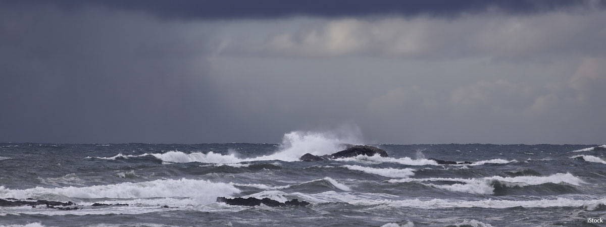
Stormy weather over the ocean can sometimes fuel the development of meteotsunamis, a series of waves typically much smaller and less destructive than those associated with seismically generated tsunamis.
Transcript
HOST: This is the NOAA Ocean Podcast, I’m Troy Kitch.
In June 2013, a series of large waves rolled into New Jersey's Barnegat Inlet, dragging a group of divers up and over a breakwater. According to local reports, the waves then crashed into a jetty where they knocked people into the water. There were injuries and property damage. And there was also a mystery: where did these waves come from? There had been no area earthquakes or underwater landslides or other obvious causes.
NOAA scientists later determined the waves were part of a meteotsunami , a small, weather-driven tsunami caused by changes in air pressure created by fast-moving severe thunderstorms, tropical storms, squalls or other storm fronts.
The unexpected large waves in New Jersey raised many questions: how frequent were meteotsunamis? Where do they occur? What conditions cause them? Could NOAA predict these events to give people advance warning?
To get at some answers, Greg Dusek, today’s guest, led a multi-year NOAA study that was published in April 2019. What did Greg’s team discover? Stay tuned.
Greg, welcome to the podcast. Could you tell us a bit about yourself?
GREG DUSEK: “I am the senior scientist and a physical oceanographer at the Center for Operational Oceanographic Products and Services, or CO-OPS. Our office is the tides and currents office of the National Ocean Service. So one of the things we do is operate tide gauges across the U.S. — water level gauges. We have over 200 of them operating in real-time, providing data every six minutes. And so, one of my jobs is to help support that network and to take that data and do scientific analysis, and to support our scientists and engineers as we hopefully get really useful data and products out to the American public.”
HOST: Let’s start with a definition of a meteotsunami.
GREG DUSEK: “They’re just what they sound like: meteorogically-driven tsunami waves. In other words, instead of tsunamis driven by an earthquake or an underwater landslide, they’re driven by the weather. And specifically, typically fast-moving storm systems, which tend to cause a wave on the ocean surface, and that wave in some cases can reach several meters in height. So their similarities with seismic tsunamis, or the more traditional tsunamis, are that the waves are similar. In other words, they’re not like the waves you see at the beach, which might be 10 seconds long. These tend be anywhere from a couple minutes to two hours long. So they’re relatively long duration rises and falls of water level.”
HOST: So the waves are similar to tsunami waves, but how do meteotsunamis differ from what you called traditional tsunamis.
GREG DUSEK: “I think when a lot of people hear the word tsunami, they immediately think to like the Japanese tsunami that occurred a number of years ago where, you know, it was just a devastating impact. And really, those seismic tsunamis are oceanic, global events. They impact, in some cases, across the entire globe. With meteotsunamis, there’s just not that same amount of energy in the wave. So often they might affect just one harbor, or one estuary. So they can be very localized. And they also tend to not be as large, because you don’t have that same amount of energy in the ocean. So it’s really those more rare and unique events which might occur once a year or maybe less frequently that we’re interested in, in terms of a potential hazard.”
HOST: How much did we know about meteotsunamis before you did your new study?
GREG DUSEK: “We’ve known a little bit about meteotsunamis I’d say over the past 20 years or so. Even as early as 1954, there was a documented event of a meteotsunami in the Great Lakes and it was reportedly on the order of ten feet high, and actually ended up causing seven deaths near Chicago. And there have been some other recent examples on the East Coast of the U.S., one in Daytona Beach in 1992, it was right around July 4th, and there was a wave people said was about ten feet high, and apparently damaged over a hundred vehicles and caused 75 or more injuries to people on the beach. “
HOST: And then there was the event in New Jersey that I talked about in the opening of the show.
GREG DUSEK: “When that happened, NOAA was really interested in saying, OK well, we have these hazardous events. Can we provide people some sort of warning if these occur, to try to prevent potential injuries or damage. So that’s really how we got into studying them. Trying to learn a little bit more about when to expect them, what conditions might lead to them, where might they occur.”
HOST: And what did you discover in your study?
GREG DUSEK: “So we found on the order of about 25 meteotsunamis a year occur along the U.S. East Coast, which I think going into this I would have thought to see maybe a handful each year. So we were surprised to see that they occur quite frequently. I think the important caveat is the vast majority of those are small. So 90 percent of the events we found were under about a foot and a half. So things that probably aren’t going to cause much of a problem. When you look at potentially hazardous events, those were probably, say, two feet or more. Those might happen once a year or so. So events that might cause damage or injury are a little less frequent. But still, about every year or so you could have one of those types of events.”
HOST: And are these events distributed along the U.S. East Coast, or do some regions see meteotsunami events more often?
GREG DUSEK: “Certain locations along the East Coast tend to see events more than others. In particular, along the Carolinas, tended to see the most events on the order of seven or eight per year in some cases. And part of that is just the location of our instrumentation. Some of our gauges might be more protected and might not observe events as easily. On the North Carolina coast, most of our gauges are out on piers and things like that and so they are more apt to see events that occur in the open ocean. But then also, a lot of what determines where we see these are where weather systems are propagating. And it just happens to be that North Carolina is exposed to summertime thunderstorms, which can drive events. Wintertime storms, like Nor’easters, which can drive events. And then tropical storms. So all the different storm forcing readily occur along the Carolina coast, which is one of the reasons we think we see them there more often than in other places.”
HOST: But we’re mostly worried about those events that cause waves over a couple of feet, right?
GREG DUSEK: “Yeah, that’s right. So what we propose is that events over about two feet is where you start worrying about potential impacts. So that might be, in the summertime, people on or around the water could be impacted, which we’ve seen in past events. And during wintertime, during a winter storm, or during a tropical storm, where people aren’t really out at the beach, then the impact starts becoming: do we see additional flooding caused by these events, do we see additional erosion caused by these events. So it’s more of a contributing factor to bad weather in large ocean events that are already occurring.”
HOST: And are we at a point now where we can begin to forecast these events?
GREG DUSEK: “We can’t forecast them yet. We being NOAA. Right now, it’s kinda baby steps for us. Right now, we’re trying to just say, ‘first, let’s figure out when and where they’re occurring and why. Then, let’s see if we can at least give people some advance warning. So if we detect a hazardous event, can we notify people quickly so that they can be prepared in case they need to take action. So we’re working on doing that now with our tide guards and then also our DART buoys, which are the same buoys used to detect seismic tsunamis. So we’re hoping to be able to combine those to give people a little bit of advance notice, maybe a couple of hours, when we detect an event.”
HOST: So you said you were surprised to learn through the study how frequently these events occur, with about 25 a year along the East Coast. Did anything else in the study surprise you?
GREG DUSEK: “You know, in the past, with these events that have been documented in the media, or have caused problems, those have always been typically thunderstorm events, either summertime storm systems or spring storm systems. We didn’t know there were going to be this many events that also occurred during nor’Easters and winter storms, or even during tropical systems. And so those findings were really surprising to me, mostly because they hadn’t really been documented much before. Some of the largest meteotsunamis we found occurred with winter storms, and so that was definitely a big surprise and it got me thinking more about these additional impacts. That it’s not just people standing around on the water, people at the beach that we’re worried about. But compounding effects of strong storm events.”
HOST: So what’s next for you with your research?
GREG DUSEK: “There is a lot of research still to do. This work is really just the starting point. We just had to have a record of events to be able to dig into them more, and so there’s a number of things we’re looking at doing, I think partly is to look at specific events and try to understand why those events are actually occurring. On the operational side, we can use the algorithm we developed for this work, to start working on detecting these events in real-time, and start giving people advanced warning.”
HOST: We hoped you learned something new in this interview with Greg Dusek, senior scientist and a physical oceanographer with the Center for Operational Oceanographic Products and Services, the NOAA tides and currents office.
And that’s all for this episode. If you like what you hear, head to iTunes and leave us a rating. It’ll help more people find our show. And head to oceanservice.noaa.gov for our show notes and for other episodes of the NOAA Ocean Podcast.
 An official website of the United States government.
Social