NOAA's Disaster Preparedness Program: Planning for Tomorrow, Today
NOAA Ocean Podcast: Episode 28
August 7, 2019
In this episode, Kate Wheelock, Chief of NOAA’s Disaster Preparedness Program, explains how her team facilitates internal communication, coordination, and preparation for all types of unforeseen disasters.
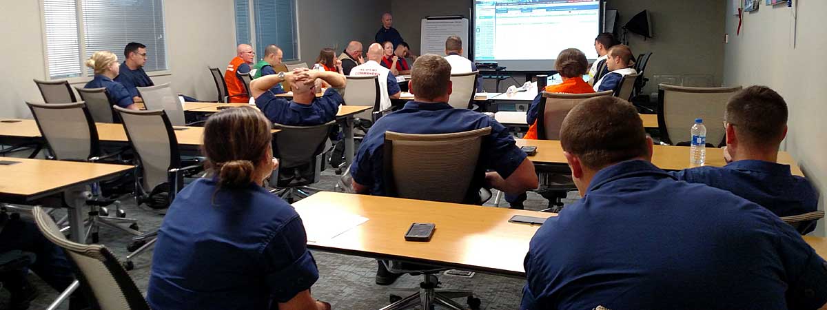
In April 2019, the United States Coast Guard Sector Mobile held their annual Continuity of Operations exercise at the NOAA Gulf of Mexico Disaster Response Center (DRC) in Mobile, Alabama. Each year, Sector Mobile simulates a disaster to test evacuating their normal facility, relocate, and resume mission operations. The exercise is designed to ensure the outlined processes and procedures work seamlessly as well as ensures the IT connectivity works across agencies. Participants were briefed about a hypothetical incoming hurricane. Then, a team of approximately 50 Coast Guard members activated and relocated to the DRC. The four-hour exercise tested pre-developed plans and agreements for both the Coast Guard and NOAA.
Transcript
HOST: This is the NOAA Ocean Podcast. I’m Abby Reid. Benjamin Franklin once said, “By failing to prepare, you are preparing to fail.” And William Shakespeare wrote in Henry V, “All things are ready, if our mind be so.” Whether you’re studying for a test, changing the oil in your car, or putting a warm jacket on in freezing weather, preparing for the future is a smart thing to do. The National Ocean Service’s Disaster Preparedness Program does just that, but on a much larger scale.
Founded in 2017, the Program expands on the activity of the Gulf of Mexico Disaster Response Center, and coordinates operational capabilities and knowledge from across the National Ocean Service and NOAA to ensure that commerce, communities, and natural resources can recover as quickly as possible from natural, and non-natural, disasters. I sat down with Kate Wheelock, Chief of the Disaster Preparedness Program, to find out more.
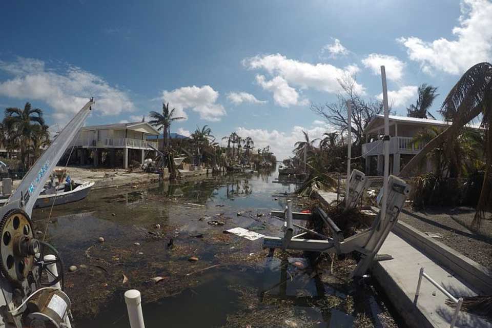
Destruction in Key West, Florida, following Hurricane Irma in September 2017. (Credit: U.S. Coast Guard)
KATE WHEELOCK: My name is Kate Wheelock. I’m the chief of the Disaster Preparedness Program in the National Ocean Service of NOAA. And within the National Ocean Service specifically, the Disaster Preparedness Program is in the Office of Response and Restoration. Our program focuses on helping NOAA and our partners effectively respond to and recover from all types of hazards, including coastal disasters.
One of the Disaster Preparedness Program mandates is to ensure that the business of NOAA can continue with as little impact as possible under any condition. So that could be a building fire, an electrical outage, cyber attack, an IT systems problem, or a you know a server gets flooded. Now we don’t have you know some of the main systems that we need to be able to collect data or keep it moving. We have to have a plan for that.
The National Ocean Service supports economies and ecosystems and communities along the coast, and uh to do that we need to have staff in beautiful places but also really precarious places. We want to make sure that we’re looking after them. And we do that. We do all these things through preparedness planning, through training, through scenario-based exercises, and through incident coordination.
HOST: The work of the Disaster Preparedness Program sounded really important internally for NOAA. But why might the public be interested in it? I asked Kate.
KATE WHEELOCK: It really enables us to be able to fulfill those really important missions that support coastal economies and coastal communities and trust resources. You know, our ability to do that depends on our ability to react effectively and safely, and in a timely manner, when disasters happen.
One success story came out of the 2017 hurricane season. The 2017 hurricane season was one that came quickly and in rapid succession, right? Folks will recall Hurricane Harvey, Hurricane Irma, and then Hurricane Maria. They happened one after another, just in rapid succession. So that required- not only was it injury upon injury or insult to insult to local communities and the economy and those kinds of things, but internally for our responders, it was a very busy and somewhat emotionally taxing and physically taxing hurricane season.
In the National Ocean Service, we have a group of people who fly over disaster areas in the immediate aftermath of a disaster.
HOST: The group Kate is referencing is the National Ocean Service’s Remote Sensing Division, located within the National Geodetic Survey.
KATE WHEELOCK: And their objective is to take high resolution photographic imagery of the area. It allows for them to go, for the public to go who may have evacuated to see if their house is still standing, but it also allows for responders to make those really critical operational decisions that they need to make about what areas they’re going to focus on.
You know, is there debris on the runways? Are there boats in shipping channels?
After Hurricane Maria in particular, there was a need for doing this kind of survey in Puerto Rico and the U.S. Virgin Islands. But that presented a lot of logistical issues for our airplanes and aircraft and crew that were coming from the continental United States. So in order to maximize the flight lines they wanted to fly, flying from Florida out to Puerto Rico and the U.S. Virgin Islands was one, going to burn some flight time and fuel. There were no air strips to land on in Puerto Rico at that time, so then they would’ve had to return back.
This was presenting a problem in terms of being able to provide that fast, efficient, and safe response. So we were having coordinating calls. This issue came up, that they were having trouble finding a place to fuel, to even find fuel, and an airstrip to use. And one of our other responding units said, ‘Hey, I know someone in Curaçao through federal kind of an interagency contact, let me call over there, see if their air strip is in good condition and if we can use it.
Communicating across the operational units and the response units allowed for this ability for them to collect that imagery much more quickly, much more effectively, cost-effectively as well, and safely. By flying the lines, going over to Curaçao, landing on the airstrip, uploading the data, refuelling, going back and continuing.
HOST: During quieter times when there aren’t major hurricanes or other disasters at play, Kate said that exercises and training are cornerstone services provided by the program.
KATE WHEELOCK: Our big thing is if we don’t practice we’re gonna get rusty. And we don’t want that to happen. So we really want to be ready for anything.
Last summer, our team went out to Hawaii and conducted a hurricane scenario exercise with our NOAA staff in Hawaii, and just weeks later Hawaii was confronted with hurricanes Lane, and then Hurricane Olivia. Hawaii being in a remote area and six hours behind you know headquarters in Washington, D.C., you know, so in a sense they’re left to manage these storms on their own in the short-term at least. And having done the exercise just before these storms arrive they will attest themselves that it provided them with the confidence, the knowledge of process, and really strong communication across the staff from all over NOAA, and they were really able to provide back to headquarters really detailed situational awareness so that we knew how we could support them out in the region.
So aside from exercises we also support training like Science of Oil Spills, Science of Chemical Releases, Science of Coastal Hazards. Notice I keep saying “science.” We’re a science agency, right? So while we are emergency responders we’re usually out there providing that scientific data, and scientific decision support.
HOST: All of these exercises and training, of course, prepare NOAA for the next big event. I asked Kate to describe what typically happens in the lead up to a major storm or other natural disaster.
KATE WHEELOCK: When a storm is coming, or any other what I call a “telegraphed event,” right, we can see something might be coming — because we don’t always have that luxury, if it's a tsunami or a tornado or something like that. But for a telegraphed event, we’re getting information from our NOAA colleagues in the Weather Service. We’re monitoring that event, we’re monitoring our staff who may be in an impacted area, and making sure they’re making contact back to their direct supervisors and letting us know what their situation is.
We’re collecting information on who’s prepositioning in terms of being ready to go into the area to respond, and what kind of assets we have that are available for that response. If we have a clear indication that there are going to be coastal impacts, then we activate our Incident Management Team.
The Incident Management Team coordinates and provides situational awareness during a pending - so even if we’ve got something kind of looking, coming along, and ongoing incidences.
HOST: Then I asked Kate how someone interested in Disaster Preparedness could pursue it as a career.
KATE WHEELOCK: What we are seeing among kind of the new generation of graduates is an interest in emergency management. And people are studying emergency management. Working with FEMA to get a you know cert to become a certified emergency manager is another route that we’re seeing people, people go.
FEMA is the Federal Emergency Management Agency.
HOST: Thanks to Kate Wheelock, the chief of the Disaster Preparedness Program, for joining the podcast.
To learn more about the Disaster Preparedness Program, visit oceanservice.noaa.gov. Thanks for listening.
 An official website of the United States government.
Social