NOAA Dives into Puget Sound and Cape Fear for the Summer
Three-year effort to improve regional tidal current predictions.
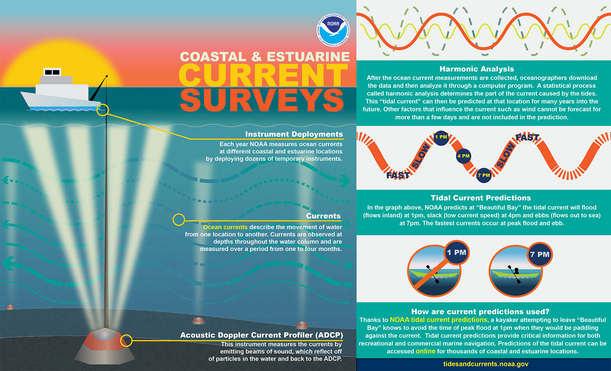
The How and Why of Current Surveys
NOAA periodically conducts current surveys in areas around the nation to ensure the accuracy of tidal current predictions. Commercial and recreational mariners depend on this information for safe navigation. | Download infographic
NOAA's Center for Operational Oceanographic Products and Services is presently conducting current surveys throughout Northern Puget Sound and the Strait of Juan de Fuca in Washington State and Cape Fear in North Carolina. The observations collected during these surveys will enable NOAA to provide tidal current predictions to commercial and recreational mariners that rely on this information for safe navigation. In order to provide the most accurate predictions possible, NOAA must periodically resurvey various coastal and estuarine locations. Survey locations are selected based on user and navigation needs, oceanographic analysis and the time since the last survey. For example, the NOAA tidal current predictions for the Puget Sound region are presently being generated from limited amounts of data collected in the 1930s-1960s. With the improvements in measurement and computing technology we have today, the accuracy of these modern predictions will be significantly improved.
The Work of Studying and Predicting the "Motion of the Ocean"
To collect the data they need, NOAA scientists deploy Acoustic Doppler Current Profilers (ADCPs) to measure the currents throughout the water column for one to four months at different locations. The observations collected from the ADCPs will be used to generate tidal current predictions at these locations.
Other Oceanographic Data Collected by CO-OPS
In addition to measurements of the currents, CO-OPS has partnered with Washington State Department of Ecology and Scripps Institution of Oceanography to deploy salinity, temperature, oxygen and pressure sensors at select locations to track the movement of different water masses. This information will also be used to support the creation of a new NOAA Operational Forecast System (OFS) hydrodynamic model in Puget Sound. OFS models provide short-term forecasts of water level, currents, water temperature and salinity in coastal areas. Also, in partnership with the University of Washington Northwest National Marine Renewable Energy Center (NNMREC) acoustic hydrophones will be deployed at a select number of locations to observe background noise and perform an acoustic census of the Sound. This acoustic census will help researchers better determine the environmental consequences of noise from anthropogenic sources like ships and construction. All of the data collected by CO-OPS in Puget Sound will be made available to other federal and state agencies and the academic and research community to support a variety of operational and research missions
Get Social
More Information
Did you know?
An Operational Forecast System provides a nowcast and forecast (up to 48 hours) of water levels, currents, salinity, water temperatures, and winds for a given area. These systems are located in coastal waters around the nation and the Great Lakes in critical ports, harbors, and estuaries.
